
FCCInfo.com
A Service of Cavell, Mertz & Associates, Inc.
(855) FCC-INFO
|
|
K256DK from 11/17/2020 K256DK from 10/22/2020 K256DK from 10/14/2015 K256DK from 06/22/2012 K256DK from 04/27/2011 K256DK from 02/08/2011 K256DK from 07/29/2008 |
|
|
||||||||||||||||
|
|
K256DK Channel: 256D 99.1 MHz Phoenix, Arizona Service: FX - A translator or application for a translator. Facility ID: 155722 Fac. Service: FX Programming Delivery Method: Unspecified Status: Construction Permit Application Accepted: 12/28/2023 Application Granted: 02/16/2024 File Number: -0000234341 K256DK CP Expires: 02/25/2027 Application Type: Minor Modification FCC Website Links: LMS Facility Details This Application Other K256DK Applications Other K256DK Applications in CDBS Including Superseded Applications Mailing Address Correspondence for K256DK Correspondence related to application -0000234341 Service Contour - Open Street Map or USGS Map (60 dBu) Service Contour - KML / Google Earth (60 dBu) Facility Type: FM STATION Class: D, A Noncommercial educational operating with no more than 10W Site Location: 33-16-19.2 N 111-44-24.5 W (NAD 83) Site Location: 33-16-19.0 N 111-44-22.0 W (Converted to NAD 27) Effective Radiated Power: 0.25 kW Antenna Center HAAT: 0 m Antenna Center AMSL: 450.5 m (1478 ft.) Antenna Center HAG: 54.9 m (180 ft.) Site Elevation: 395.6 m. (1298 ft.) Height Overall*: 82.3 m (270 ft.) (* As Filed In This Application, may differ from ASR Data, Below.) Directional Antenna Antenna Make/Model: Nicom BKG77-1 Antenna ID: 0 Polarization: H
| ||||||||||||||||||
| Antenna Data for Antenna Id: 0 K256DK FX File: -0000234341 Nicom - BKG77-1 Service: FX | 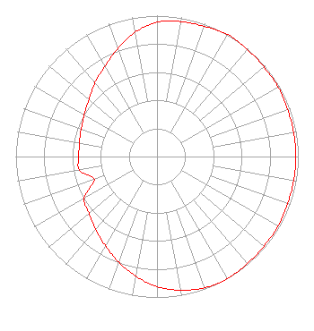 | ||||||||||||||||||
| Azimuth | Ratio | Azimuth | Ratio | Azimuth | Ratio | Azimuth | Ratio | ||||||||||||
| 0 | 0.953 | 10 | 0.973 | 20 | 0.983 | 30 | 1.000 | ||||||||||||
| 40 | 0.992 | 50 | 0.988 | 60 | 0.988 | 70 | 0.983 | ||||||||||||
| 80 | 0.983 | 90 | 0.983 | 100 | 0.983 | 110 | 0.983 | ||||||||||||
| 120 | 0.988 | 130 | 0.988 | 140 | 0.992 | 150 | 1.000 | ||||||||||||
| 160 | 0.991 | 170 | 0.963 | 180 | 0.923 | 190 | 0.862 | ||||||||||||
| 200 | 0.797 | 210 | 0.731 | 220 | 0.676 | 230 | 0.628 | ||||||||||||
| 240 | 0.594 | 250 | 0.471 | 260 | 0.558 | 270 | 0.553 | ||||||||||||
| 280 | 0.558 | 290 | 0.571 | 300 | 0.594 | 310 | 0.628 | ||||||||||||
| 320 | 0.682 | 330 | 0.738 | 340 | 0.815 | 350 | 0.897 | ||||||||||||
Structure Registration Number 1210712 Structure Type: TOWER Registered To: EIP Holdings II, LLC Structure Address: Germann & Greenfield Rd Gilbert, AZ County Name: Maricopa County ASR Issued: 11/30/2023 Date Built: 05/07/2002 Site Elevation: 395.6 m (1298 ft.) Structure Height: 76.2 m (250 ft.) Height Overall: 82.3 m (270 ft.) Overall Height AMSL: 477.9 m (1568 ft.) FAA Determination: 12/09/1999 FAA Study #: 99-AWP-2308-OE FAA Circular #: 70/7460-1J Paint & Light FAA Chapters: 4, 8, 13 PRIOR FAA # 98-AWP-3286-OE 33-16-19.2 N 111-44-24.5 W (NAD 83) 33-16-19.0 N 111-44-22.0 W (Converted to NAD 27) |
4501 Broadway Miami, AZ 85539 Phone: 650-520-6022 Corporation | Title: President Date: 12/28/2023 Application Certifier 1TV.COM, INC. Rocket Radio Corporation 4501 Broadway Miami, AZ 85539 Applicant CHARLES M ANDERSON Anderson Associates. 5900 Lake Cyrus Drive Hoover, AL 35244 BROADCAST ENGINEERING CONSULTANT John Neely Miller And Neely Pc 4 Simms Ct Kensington, MD 20895 | |||||||||||||||||