
FCCInfo.com
A Service of Cavell, Mertz & Associates, Inc.
(855) FCC-INFO
|
|
|
|
|
||||||||||||||||
|
|
W215BH Channel: 215D 90.9 MHz Chattanooga, Tennessee Service: FX - A translator or application for a translator. Facility ID: 94111 Fac. Service: FX Programming Delivery Method: Unspecified Status: Construction Permit Application Accepted: 01/19/2024 Application Granted: 02/06/2024 File Number: -0000235843 W215BH CP Expires: 02/06/2027 Application Type: Minor Modification FCC Website Links: LMS Facility Details This Application Other W215BH Applications Other W215BH Applications in CDBS Including Superseded Applications Mailing Address Correspondence for W215BH Correspondence related to application -0000235843 Service Contour - Open Street Map or USGS Map (60 dBu) Service Contour - KML / Google Earth (60 dBu) Facility Type: NON-COMMERCIAL EDUC. FM Class: D, A Noncommercial educational operating with no more than 10W Site Location: 35-00-34.5 N 85-20-40.5 W (NAD 83) Site Location: 35-00-34.2 N 85-20-40.7 W (Converted to NAD 27) Effective Radiated Power: 0.25 kW Antenna Center HAAT: 0 m Antenna Center AMSL: 664.5 m (2180 ft.) Antenna Center HAG: 22 m (72 ft.) Site Elevation: 642.5 m. (2108 ft.) Height Overall*: 33.2 m (109 ft.) (* As Filed In This Application, may differ from ASR Data, Below.) Directional Antenna Antenna Make/Model: Nicom BKG77-3-0.75 Antenna ID: 118582 Polarization: H
| ||||||||||||||||||
| Antenna Data for Antenna Id: 118582 W215BH FX File: -0000235843 Nicom - BKG77-3-0.75 Service: FX | 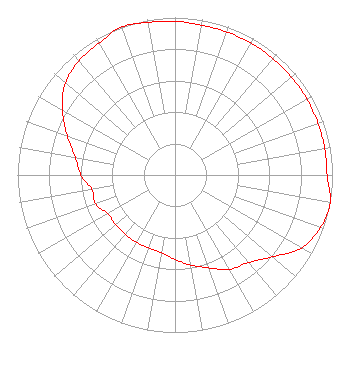 | ||||||||||||||||||
| Azimuth | Ratio | Azimuth | Ratio | Azimuth | Ratio | Azimuth | Ratio | ||||||||||||
| 0 | 0.976 | 10 | 0.966 | 20 | 0.966 | 30 | 0.966 | ||||||||||||
| 40 | 0.966 | 50 | 0.966 | 60 | 0.966 | 70 | 0.966 | ||||||||||||
| 80 | 0.966 | 90 | 0.966 | 100 | 1.000 | 110 | 0.982 | ||||||||||||
| 120 | 0.927 | 130 | 0.807 | 140 | 0.727 | 150 | 0.692 | ||||||||||||
| 160 | 0.627 | 170 | 0.581 | 180 | 0.536 | 190 | 0.501 | ||||||||||||
| 200 | 0.493 | 210 | 0.493 | 220 | 0.493 | 230 | 0.493 | ||||||||||||
| 240 | 0.493 | 250 | 0.536 | 260 | 0.536 | 270 | 0.598 | ||||||||||||
| 280 | 0.643 | 290 | 0.728 | 300 | 0.826 | 310 | 0.908 | ||||||||||||
| 320 | 0.947 | 330 | 0.966 | 340 | 1.000 | 350 | 0.984 | ||||||||||||
Structure Registration Number 1225696 Structure Type: LTOWER Registered To: Pinnacle Towers LLC Structure Address: 121 Lyerly Street Lookout Mountain, TN County Name: Hamilton County ASR Issued: 04/12/2019 Date Built: 09/03/1998 Site Elevation: 642.5 m (2108 ft.) Structure Height: 30.8 m (101 ft.) Height Overall: 33.2 m (109 ft.) Overall Height AMSL: 675.7 m (2217 ft.) FAA Determination: 04/11/2019 FAA Study #: 2018-ASO-27873-OE Paint & Light FAA Chapters: NONE PRIOR STUDY 2017-ASO-13471-OE 35-00-34.5 N 85-20-40.5 W (NAD 83) 35-00-34.2 N 85-20-40.7 W (Converted to NAD 27) |
1722 Treble Drive Humble, TX 77338 Phone: 214-353-9293 Not-for-Profit | Title: Coo Date: 01/19/2024 Application Certifier Hope Media Group 1722 Treble Drive Humble, TX 77338 Applicant Davina Sashkin, Esq Wilkinson Barker Knauer, Llp 1800 M Street, Nw Suite 800n Washington, DC 20036 Jim Turvaville Turbo Tech Services 360 Patton Street - Po Box 144 Mobeetie, TX 79061 Consulting Engineer | |||||||||||||||||