
FCCInfo.com
A Service of Cavell, Mertz & Associates, Inc.
(855) FCC-INFO
|
|
KGVB from 03/20/2008 KGVB from 02/06/2008 |
|
|
||||||||||||||||
|
|
KRGH Channel: 215C3 90.9 MHz Holliday, Texas Service: FM - A full-service FM station or application. Facility ID: 173112 Fac. Service: FM Status: License Application Accepted: 02/27/2024 Application Granted: 02/28/2024 File Number: -0000238656 License Expires: 08/01/2029 Application Type: Amendment FCC Website Links: LMS Facility Details This Application Other KRGH Applications Other KRGH Applications in CDBS Including Superseded Applications Mailing Address Correspondence for KRGH Correspondence related to application -0000238656 Service Contour - Open Street Map or USGS Map (60 dBu) Service Contour - KML / Google Earth (60 dBu) Public Inspection Files Facility Type: NON-COMMERCIAL EDUC. FM Class: C3, A Zone II station; with 6kW-25kW ERP and a class contour distance 28km-39km Site Location: 33-44-18.8 N 98-54-29.3 W (NAD 83) Site Location: 33-44-18.4 N 98-54-28.1 W (Converted to NAD 27) Effective Radiated Power: 22 kW Horiz. ; 13 kW Vert. Transmitter Output Power: 5.7 kW Antenna Center HAAT: 107 m (351 ft.) Antenna Center AMSL: 445 m (1460 ft.) Antenna Center HAG: 95 m (312 ft.) Site Elevation: 349.6 m. (1147 ft.) Height Overall*: 106.1 m (348 ft.) (* As Filed In This Application, may differ from ASR Data, Below.) Directional Antenna Antenna Make/Model: Propagation System Inc FM5CLOG, 4 sections Antenna ID: 0 Polarization: H | ||||||||||||||||||
| Antenna Data for Antenna Id: 0 KRGH FM File: -0000238656 Propagation System Inc - FM5CLOG, 4 sections Service: FM | 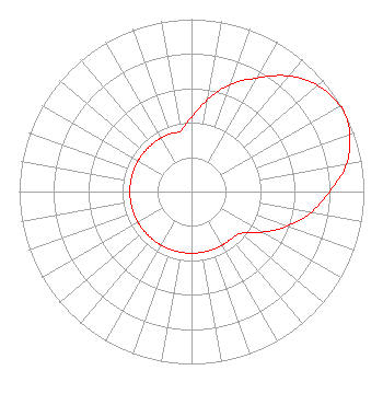 | ||||||||||||||||||
| Azimuth | Ratio | Azimuth | Ratio | Azimuth | Ratio | Azimuth | Ratio | ||||||||||||
| 0 | 0.431 | 10 | 0.542 | 20 | 0.662 | 30 | 0.761 | ||||||||||||
| 40 | 0.876 | 50 | 0.958 | 60 | 0.994 | 62 | 1.000 | ||||||||||||
| 70 | 0.977 | 80 | 0.914 | 90 | 0.800 | 100 | 0.704 | ||||||||||||
| 110 | 0.590 | 120 | 0.473 | 130 | 0.376 | 140 | 0.358 | ||||||||||||
| 150 | 0.358 | 160 | 0.358 | 170 | 0.358 | 180 | 0.358 | ||||||||||||
| 190 | 0.358 | 200 | 0.358 | 210 | 0.358 | 220 | 0.358 | ||||||||||||
| 230 | 0.358 | 240 | 0.358 | 250 | 0.358 | 260 | 0.358 | ||||||||||||
| 270 | 0.358 | 280 | 0.358 | 290 | 0.358 | 300 | 0.358 | ||||||||||||
| 310 | 0.358 | 320 | 0.358 | 330 | 0.358 | 340 | 0.358 | ||||||||||||
| 350 | 0.358 | ||||||||||||||||||
Structure Registration Number 1273924 Structure Type: GTOWER Registered To: SBA Towers IX, LLC Structure Address: 203 Walnut Rd. (tx18170-a) Holliday, TX County Name: Archer County ASR Issued: 05/08/2017 Date Built: 05/20/2010 Site Elevation: 349.6 m (1147 ft.) Structure Height: 101 m (331 ft.) Height Overall: 106.1 m (348 ft.) Overall Height AMSL: 455.7 m (1495 ft.) FAA Determination: 05/02/2017 FAA Study #: 2017-ASW-5288-OE FAA Circular #: 70/7460-1K Paint & Light FAA Chapters: 4, 8, 12 PRIOR STUDY 2010-ASW-710-OE 33-44-18.8 N 98-54-29.3 W (NAD 83) 33-44-18.4 N 98-54-28.1 W (Converted to NAD 27) |
4111 Plains Blvd Amarillo, TX 79106 Phone: 806-353-1488 Not-for-Profit | Title: President Date: 02/27/2024 Application Certifier Grace Community Church Of Amarillo 4111 Plains Blvd Amarillo, TX 79106 Applicant Jim Turvaville Turbo Tech Services 360 Patton Street - Po Box 144 Mobeetie, TX 79061 John C. Trent, Esq. Putbrese Hunsaker & Trent, P.c. 200 South Church Street Woodstock, VA 22664 Counsel | |||||||||||||||||