
FCCInfo.com
A Service of Cavell, Mertz & Associates, Inc.
(855) FCC-INFO
|
|
KYLA from 02/09/2012 KYLA from 03/19/2007 KYLA from 01/15/1997 KYLA from 09/06/1991 |
|
|
||||||||||||||||
|
|
KYLA Channel: 224A 92.7 MHz Fountain Valley, California Service: FS - A full service FM station auxiliary transmitting antenna or application. Facility ID: 9304 Fac. Service: FM Analog & Digital Status: Construction Permit Application Accepted: 03/01/2024 Application Granted: 03/29/2024 File Number: -0000240177 KYLA CP Expires: 03/29/2027 Application Type: Construction Permit FCC Website Links: LMS Facility Details This Application Other KYLA Applications Other KYLA Applications in CDBS Including Superseded Applications Mailing Address Correspondence for KYLA Correspondence related to application -0000240177 Service Contour - Open Street Map or USGS Map (60 dBu) Service Contour - KML / Google Earth (60 dBu) Public Inspection Files Facility Type: NON-COMMERCIAL EDUC. FM Class: A, A Zone I; I-A; or II station; with 0.1kW-6kW ERP and a class contour distance <=28km Site Location: 33-36-20.2 N 117-48-41.0 W (NAD 83) Site Location: 33-36-20.1 N 117-48-37.8 W (Converted to NAD 27) Effective Radiated Power: 0.69 kW Antenna Center HAAT: 307.5 m (1009 ft.) Antenna Center AMSL: 373 m (1224 ft.) Antenna Center HAG: 19 m (62 ft.) Site Elevation: 354 m. (1161 ft.) Height Overall*: 36.3 m (119 ft.) (* As Filed In This Application, may differ from ASR Data, Below.) Directional Antenna Antenna Make/Model: None Antenna ID: 69-2019-08-06 Polarization: | ||||||||||||||||||
| Antenna Data for Antenna Id: 69-2019-08-06 KYLA FS File: -0000240177 None - Service: FS | 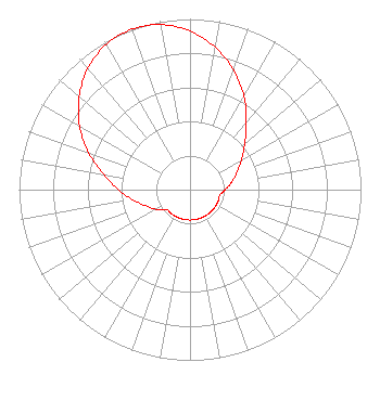 | ||||||||||||||||||
| Azimuth | Ratio | Azimuth | Ratio | Azimuth | Ratio | Azimuth | Ratio | ||||||||||||
| 0 | 0.929 | 10 | 0.847 | 20 | 0.745 | 30 | 0.631 | ||||||||||||
| 40 | 0.513 | 50 | 0.417 | 60 | 0.348 | 70 | 0.290 | ||||||||||||
| 80 | 0.248 | 90 | 0.205 | 100 | 0.178 | 110 | 0.178 | ||||||||||||
| 120 | 0.178 | 130 | 0.178 | 140 | 0.178 | 150 | 0.178 | ||||||||||||
| 160 | 0.178 | 170 | 0.178 | 180 | 0.178 | 190 | 0.178 | ||||||||||||
| 200 | 0.178 | 210 | 0.178 | 220 | 0.178 | 230 | 0.180 | ||||||||||||
| 240 | 0.230 | 250 | 0.277 | 260 | 0.341 | 270 | 0.417 | ||||||||||||
| 280 | 0.513 | 290 | 0.631 | 300 | 0.745 | 310 | 0.847 | ||||||||||||
| 320 | 0.929 | 330 | 0.982 | 340 | 1.000 | 350 | 0.982 | ||||||||||||
Structure Registration Number 1224332 Structure Type: TOWER Registered To: Pinnacle Towers LLC Structure Address: 21474 Vista Ridge Road Irvine, CA County Name: Orange County ASR Issued: 05/06/2016 Date Built: 09/03/1998 Site Elevation: 353.6 m (1160 ft.) Structure Height: 30.5 m (100 ft.) Height Overall: 36.3 m (119 ft.) Overall Height AMSL: 389.9 m (1279 ft.) FAA Determination: 05/30/2012 FAA Study #: 2012-AWP-4111-OE Paint & Light FAA Chapters: NONE PRIOR STUDY 2011-AWP-588-OE 33-36-20.2 N 117-48-41.0 W (NAD 83) 33-36-20.1 N 117-48-37.8 W (Converted to NAD 27) |
5700 West Oaks Boulevard Rocklin, CA 95765 Phone: 916-251-1600 Not-for-Profit | Title: Cfo Date: 03/01/2024 Application Certifier EDUCATIONAL MEDIA FOUNDATION Educational Media Foundation 5700 West Oaks Boulevard Rocklin, CA 95765 Applicant Mary O'Connor Wilkinson Barker Knauer, Llp 1800 M Street, N.w Washington, DC 20036 David Velasquez Education Media Foundation 5700 West Oaks Blvd. Rocklin, CA 95765 Signal Development | |||||||||||||||||