
FCCInfo.com
A Service of Cavell, Mertz & Associates, Inc.
(855) FCC-INFO
|
|
KAWV from 06/13/2007 KAWV from 05/14/2007 |
|  |
|
|||||||||||||||
|
|
KAWV Channel: 202C3 88.3 MHz Alice, Texas Service: FM - A full-service FM station or application. Facility ID: 91097 Fac. Service: FM Status: License Application Accepted: 04/01/2015 Application Granted: 04/15/2015 File Number: BLED-20150401AEN License Expires: 00/00/0000 Prefix Type: This is a license for a noncommercial educational FM station Application Type: License To Cover FCC Website Links: LMS Facility Details This Application CDBS Application Other KAWV Applications Other KAWV Applications in CDBS Including Superseded Applications Mailing Address Correspondence for KAWV Correspondence related to application BLED-20150401AEN Service Contour - Open Street Map or USGS Map (60 dBu) Service Contour - KML / Google Earth (60 dBu) Public Inspection Files Facility Type: NON-COMMERCIAL EDUC. FM Class: C3, A Zone II station; with 6kW-25kW ERP and a class contour distance 28km-39km Site Location: 27-45-09.1 N 98-07-56.0 W (NAD 83) Site Location: 27-45-08.0 N 98-07-55.0 W (Converted to NAD 27) Effective Radiated Power: 0 kW Horiz. ; 13.5 kW Vert. Transmitter Output Power: 2.117 kW Antenna Center HAAT: 0 m Horiz.; 111 m Vert. Antenna Center AMSL: 0 m Horiz.; 183 m Vert. Antenna Center HAG: 0 m Horiz.; 107 m Vert. Calculated Site Elevation: m. Height Overall*: 122 m (400 ft.) (* As Filed In This Application, may differ from ASR Data, Below.) Directional Antenna Antenna Make/Model: Shivley 6513-3-DA, three sections Antenna ID: 118250 Polarization:
| ||||||||||||||||||
| Antenna Data for Antenna Id: 118250 KAWV FM File: BLED-20150401AEN Shivley - 6513-3-DA, three sections Service: FM | 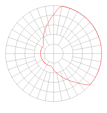 | ||||||||||||||||||
| Azimuth | Ratio | Azimuth | Ratio | Azimuth | Ratio | Azimuth | Ratio | ||||||||||||
| 0 | 0.804 | 10 | 1.000 | 20 | 1.000 | 30 | 1.000 | ||||||||||||
| 40 | 1.000 | 50 | 1.000 | 60 | 1.000 | 70 | 1.000 | ||||||||||||
| 80 | 1.000 | 90 | 1.000 | 100 | 1.000 | 110 | 1.000 | ||||||||||||
| 120 | 1.000 | 130 | 1.000 | 140 | 0.804 | 150 | 0.646 | ||||||||||||
| 160 | 0.519 | 170 | 0.417 | 180 | 0.335 | 190 | 0.269 | ||||||||||||
| 200 | 0.269 | 210 | 0.269 | 220 | 0.269 | 230 | 0.269 | ||||||||||||
| 240 | 0.269 | 250 | 0.269 | 260 | 0.269 | 270 | 0.269 | ||||||||||||
| 280 | 0.269 | 290 | 0.269 | 300 | 0.269 | 310 | 0.269 | ||||||||||||
| 320 | 0.335 | 330 | 0.417 | 340 | 0.519 | 350 | 0.646 | ||||||||||||
Structure Registration Number 1051014 [ASR Heights Differ from KAWV Application] Structure Type: GTOWER Registered To: American Towers LLC Structure Address: 3.4 Mi W On Hwy 44 (#207940) Alice, TX County Name: Jim Wells County ASR Issued: 07/19/2021 Date Built: 01/01/1973 Site Elevation: 75.9 m (249 ft.) Structure Height: 121.9 m (400 ft.) Height Overall: 121.9 m (400 ft.) Overall Height AMSL: 197.8 m (649 ft.) FAA Determination: 07/15/2021 FAA Study #: 2021-ASW-10329-OE FAA Circular #: 70/7460-1M Paint & Light FAA Chapters: 4, 8, 15 PRIOR STUDY 1998-ASW-1855-OE 27-45-09.2 N 98-07-56.0 W (NAD 83) 27-45-08.1 N 98-07-55.0 W (Converted to NAD 27) |
P.o. Drawer 2440 Tupelo, MS 38803 Phone: 662-844-8888 Not-for-Profit | Date: 04/01/2015 Application Certifier EDUCATIONAL MEDIA FOUNDATION 5700 West Oaks Blvd Rocklin, CA 95765 Applicant STEPHEN WILDE 5700 West Oaks Blvd Rocklin, CA 95765 BROADCAST ENGINEER MARY N. O'CONNOR Wilkinson Barker Knauer, Llp | |||||||||||||||||