
FCCInfo.com
A Service of Cavell, Mertz & Associates, Inc.
(855) FCC-INFO
|
|
|
|
|
||||||||||||||||
|
|
K220DK Channel: 220D 91.9 MHz Buffalo, Wyoming Service: FX - A translator or application for a translator. Facility ID: 55092 Fac. Service: FX Programming Delivery Method: Unspecified Status: License Application Accepted: 08/10/1999 Application Granted: 11/10/1999 File Number: BLFT-19990810UA License Expires: 00/00/0000 Prefix Type: This is a license for a translator Application Type: License To Cover FCC Website Links: LMS Facility Details This Application CDBS Application Other K220DK Applications Other K220DK Applications in CDBS Including Superseded Applications Mailing Address Correspondence for K220DK Correspondence related to application BLFT-19990810UA Service Contour - Open Street Map or USGS Map (60 dBu) Service Contour - KML / Google Earth (60 dBu) Class: D, A Noncommercial educational operating with no more than 10W Site Location: 44-20-49.9 N 106-43-27.2 W (NAD 83) Site Location: 44-20-50.0 N 106-43-25.0 W (Converted to NAD 27) Effective Radiated Power: 0.125 kW Transmitter Output Power: 0.122 kW Antenna Center HAAT: -59 m Horiz.; 0 m Vert. Antenna Center AMSL: 1528 m (5013 ft.) Antenna Center HAG: 37 m (121 ft.) Calculated Site Elevation: 1491 m. (4892 ft.) Height Overall*: 76 m (249 ft.) (* As Filed In This Application, may differ from ASR Data, Below.) Directional Antenna Antenna Make/Model: None Antenna ID: 16125 Polarization:
| ||||||||||||||||||
| Antenna Data for Antenna Id: 16125 K220DK FX File: BLFT-19990810UA None - Service: FX Pattern and Field Values Include a 90° Clockwise Rotation | 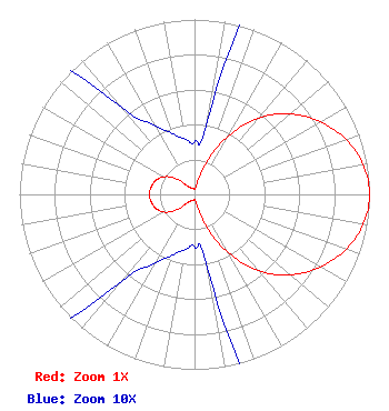 | ||||||||||||||||||
| Azimuth | Ratio | Azimuth | Ratio | Azimuth | Ratio | Azimuth | Ratio | ||||||||||||
| 0 | 0.030 | 10 | 0.045 | 20 | 0.187 | 30 | 0.388 | ||||||||||||
| 40 | 0.570 | 50 | 0.715 | 60 | 0.829 | 70 | 0.920 | ||||||||||||
| 80 | 0.979 | 90 | 1.000 | 100 | 0.979 | 110 | 0.920 | ||||||||||||
| 120 | 0.829 | 130 | 0.715 | 140 | 0.570 | 150 | 0.388 | ||||||||||||
| 160 | 0.187 | 170 | 0.045 | 180 | 0.030 | 190 | 0.032 | ||||||||||||
| 200 | 0.037 | 210 | 0.046 | 220 | 0.065 | 230 | 0.142 | ||||||||||||
| 240 | 0.202 | 250 | 0.234 | 260 | 0.250 | 270 | 0.260 | ||||||||||||
| 280 | 0.250 | 290 | 0.234 | 300 | 0.202 | 310 | 0.142 | ||||||||||||
| 320 | 0.065 | 330 | 0.046 | 340 | 0.037 | 350 | 0.032 | ||||||||||||
Structure Registration Number 1007607 Structure Type: GTOWER Registered To: Legend Communications of Wyoming, LLC Structure Address: 1.3 Miles West Of Juncture Of I-25 And Us 16 Buffalo, WY County Name: Johnson County ASR Issued: 11/01/2012 Date Built: 01/01/1994 Site Elevation: 1491.1 m (4892 ft.) Structure Height: 75.3 m (247 ft.) Height Overall: 76.2 m (250 ft.) Overall Height AMSL: 1567.3 m (5142 ft.) FAA Determination: 05/24/2012 FAA Study #: 2012-ANM-844-OE FAA Circular #: 70/7460-1K Paint & Light FAA Chapters: 3, 4, 5, 12 PRIOR STUDY 1994-ANM-817-OE 44-20-47.9 N 106-43-30.4 W (NAD 83) 44-20-48.0 N 106-43-28.2 W (Converted to NAD 27) |
Kemc - Fm 1500 University Drive Billings, MT 59101 Phone: 406-657-2941 | Date: 08/10/1999 Application Certifier MONTANA STATE UNIVERSITY - BILLINGS Montana State University-billings 1500 N. 30th Street Billings, MT 59101 Applicant | |||||||||||||||||