
FCCInfo.com
A Service of Cavell, Mertz & Associates, Inc.
(855) FCC-INFO
|
|
KDCZ from 03/21/2008 KDCZ from 03/10/1997 KDCZ from 12/23/1996 |
|  |
|
|||||||||||||||
|
|
KDCZ Channel: 299A 107.7 MHz St. Charles, Minnesota Service: FM - A full-service FM station or application. Facility ID: 56252 Fac. Service: FM Status: License 73.215 Station Application Accepted: 04/10/1998 Application Granted: 06/10/2003 File Number: BLH-19980410KF License Expires: 00/00/0000 Prefix Type: This is a license for a commercial FM station Application Type: License To Cover FCC Website Links: LMS Facility Details This Application CDBS Application Other KDCZ Applications Other KDCZ Applications in CDBS Including Superseded Applications Mailing Address Correspondence for KDCZ Correspondence related to application BLH-19980410KF Service Contour - Open Street Map or USGS Map (60 dBu) Service Contour - KML / Google Earth (60 dBu) Public Inspection Files Facility Type: FM STATION Class: A, A Zone I; I-A; or II station; with 0.1kW-6kW ERP and a class contour distance <=28km Site Location: 44-02-24.9 N 92-13-05.6 W (NAD 83) Site Location: 44-02-25.0 N 92-13-05.0 W (Converted to NAD 27) Effective Radiated Power: 1.95 kW Transmitter Output Power: 2.369 kW Antenna Center HAAT: 174 m (571 ft.) Antenna Center AMSL: 533 m (1749 ft.) Antenna Center HAG: 147 m (482 ft.) Site Elevation: 386 m. (1266 ft.) Height Overall*: 152 m (499 ft.) (* As Filed In This Application, may differ from ASR Data, Below.) Directional Antenna Antenna Make/Model: None Dielectric DCR-DCPJ-1/3, 1 section Antenna ID: 15008 Polarization: | ||||||||||||||||||
| Antenna Data for Antenna Id: 15008 KDCZ FM File: BLH-19980410KF None - Dielectric DCR-DCPJ-1/3, 1 section Service: FM | 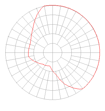 | ||||||||||||||||||
| Azimuth | Ratio | Azimuth | Ratio | Azimuth | Ratio | Azimuth | Ratio | ||||||||||||
| 0 | 1.000 | 10 | 1.000 | 20 | 1.000 | 30 | 1.000 | ||||||||||||
| 40 | 1.000 | 50 | 1.000 | 60 | 1.000 | 70 | 1.000 | ||||||||||||
| 80 | 1.000 | 90 | 1.000 | 100 | 1.000 | 110 | 1.000 | ||||||||||||
| 120 | 1.000 | 130 | 1.000 | 140 | 1.000 | 150 | 0.860 | ||||||||||||
| 160 | 0.690 | 170 | 0.490 | 180 | 0.390 | 190 | 0.300 | ||||||||||||
| 200 | 0.300 | 210 | 0.315 | 220 | 0.323 | 230 | 0.360 | ||||||||||||
| 240 | 0.400 | 250 | 0.460 | 260 | 0.510 | 270 | 0.510 | ||||||||||||
| 280 | 0.505 | 290 | 0.505 | 300 | 0.530 | 310 | 0.580 | ||||||||||||
| 320 | 0.650 | 330 | 0.760 | 340 | 0.890 | 350 | 1.000 | ||||||||||||
Structure Registration Number 1014477 Structure Type: TOWER Registered To: Townsquare Media Rochester, LLC Structure Address: 3.1 Mi Ne Of Int Sr 42 & Us 14 Approx 3.4 Mi N Eyota, MN County Name: Olmsted County ASR Issued: 12/08/2021 Date Built: 02/02/1998 Site Elevation: 385.6 m (1265 ft.) Structure Height: 152 m (499 ft.) Height Overall: 152 m (499 ft.) Overall Height AMSL: 537.6 m (1764 ft.) FAA Determination: 12/04/1996 FAA Study #: 96-AGL-3852-OE FAA Circular #: 70/7460-1J Paint & Light FAA Chapters: 3, 4, 5, 13 44-02-25.0 N 92-13-06.0 W (NAD 83) 44-02-25.1 N 92-13-05.4 W (Converted to NAD 27) |
1 Manhattanville Road Suite 202 Purchase, NY 10577 Phone: 203-861-0900 Limited Liability Company | Date: 04/10/1998 Application Certifier ST. CHARLES BROADCASTING CO. INC. Richard R. Radke 1220 4th Avenue Sw Rochester, MN 55902 Applicant | |||||||||||||||||
| |||||||||||||||||||