
FCCInfo.com
A Service of Cavell, Mertz & Associates, Inc.
(855) FCC-INFO
|
|
|
|  |
|
|||||||||||||||
|
|
KBDD Channel: 220C2 91.9 MHz Winfield, Kansas Service: FM - A full-service FM station or application. Facility ID: 86319 Fac. Service: FM Status: License Application Accepted: 04/28/2000 Application Granted: 07/31/2000 File Number: BLED-20000419ACA License Expires: 00/00/0000 Prefix Type: This is a license for a noncommercial educational FM station Application Type: License To Cover FCC Website Links: LMS Facility Details This Application CDBS Application Other KBDD Applications Other KBDD Applications in CDBS Including Superseded Applications Mailing Address Correspondence for KBDD Correspondence related to application BLED-20000419ACA Service Contour - Open Street Map or USGS Map (60 dBu) Service Contour - KML / Google Earth (60 dBu) Public Inspection Files Facility Type: NON-COMMERCIAL EDUC. FM Class: C2, A Zone II station; with 25kW-50kW ERP and a class contour distance 39km-52km Site Location: 37-22-56.1 N 96-57-21.1 W (NAD 83) Site Location: 37-22-56.0 N 96-57-20.0 W (Converted to NAD 27) Effective Radiated Power: 48 kW Transmitter Output Power: 6.8 kW Antenna Center HAAT: 150 m (492 ft.) Antenna Center AMSL: 525 m (1722 ft.) Antenna Center HAG: 135 m (443 ft.) Site Elevation: 390 m. (1280 ft.) Height Overall*: 152 m (499 ft.) (* As Filed In This Application, may differ from ASR Data, Below.) Directional Antenna Antenna Make/Model: Shivley 6810-6RDA Antenna ID: 31322 Polarization: | ||||||||||||||||||
| Antenna Data for Antenna Id: 31322 KBDD FM File: BLED-20000419ACA Shivley - 6810-6RDA Service: FM | 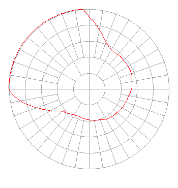 | ||||||||||||||||||
| Azimuth | Ratio | Azimuth | Ratio | Azimuth | Ratio | Azimuth | Ratio | ||||||||||||
| 0 | 0.900 | 10 | 0.750 | 20 | 0.620 | 30 | 0.563 | ||||||||||||
| 40 | 0.563 | 45 | 0.563 | 50 | 0.563 | 60 | 0.563 | ||||||||||||
| 70 | 0.563 | 80 | 0.547 | 90 | 0.532 | 100 | 0.502 | ||||||||||||
| 110 | 0.488 | 120 | 0.474 | 130 | 0.460 | 135 | 0.454 | ||||||||||||
| 140 | 0.447 | 150 | 0.435 | 160 | 0.410 | 170 | 0.399 | ||||||||||||
| 180 | 0.387 | 190 | 0.376 | 200 | 0.366 | 210 | 0.376 | ||||||||||||
| 220 | 0.399 | 225 | 0.417 | 230 | 0.435 | 240 | 0.547 | ||||||||||||
| 250 | 0.689 | 260 | 0.867 | 270 | 1.000 | 280 | 1.000 | ||||||||||||
| 290 | 1.000 | 300 | 1.000 | 310 | 1.000 | 315 | 1.000 | ||||||||||||
| 320 | 1.000 | 330 | 1.000 | 340 | 1.000 | 350 | 1.000 | ||||||||||||
| 355 | 1.000 | ||||||||||||||||||
Structure Registration Number 1056783 [ASR Heights Differ from KBDD Application] Structure Type: TOWER Registered To: FAMILY WORSHIP CENTER CHURCH, INC. Structure Address: Int. Of Us77 & Us160 N 11m To Us77 & Sr 15 Winfield, KS County Name: Cowley County ASR Issued: 10/20/2009 Date Built: 01/31/2000 Site Elevation: 390 m (1280 ft.) Structure Height: 150 m (492 ft.) Height Overall: 150 m (492 ft.) Overall Height AMSL: 540 m (1772 ft.) FAA Determination: 09/09/1998 FAA Study #: 98-ACE-1098-OE FAA Circular #: 70/7460-1J Paint & Light FAA Chapters: 4, 6, 13 STRUCTURE REACHED GREATEST HEIGHT 1/31/2000 37-22-56.0 N 96-57-21.0 W (NAD 83) 37-22-55.9 N 96-57-19.9 W (Converted to NAD 27) |
8919 World Ministry Avenue P.o. Box 262550 Baton Rouge, LA 70826 Phone: 225-768-3102 | Date: 04/19/2000 Application Certifier AMERICAN FAMILY ASSOCIATION P.o. Drawer 2440 Tupelo, MS 38803 Applicant TECHNICAL CONSULTANT | |||||||||||||||||