
FCCInfo.com
A Service of Cavell, Mertz & Associates, Inc.
(855) FCC-INFO
|
|
WLKK from 10/02/2000 WLKK from 08/21/1992 WLKK from 03/05/1991 WLKK from 11/22/1988 |
|  |
|
|||||||||||||||
|
|
WLKK Channel: 299B 107.7 MHz Wethersfield Twnshp, New York Service: FM - A full-service FM station or application. Facility ID: 9250 Fac. Service: FM Analog & Digital Status: License Application Accepted: 01/22/2015 Application Granted: 01/29/2015 File Number: BLH-20150122ABI License Expires: 00/00/0000 Prefix Type: This is a license for a commercial FM station Application Type: License To Cover FCC Website Links: LMS Facility Details This Application CDBS Application Other WLKK Applications Other WLKK Applications in CDBS Including Superseded Applications Mailing Address Correspondence for WLKK Correspondence related to application BLH-20150122ABI Service Contour - Open Street Map or USGS Map (54 dBu) Service Contour - KML / Google Earth (54 dBu) Public Inspection Files History Cards for WLKK Facility Type: FM STATION Class: B, A Zone I or I-A station; with 25kW-50kW ERP and a class contour distance 39km-52km Site Location: 42-37-25.2 N 78-17-20.1 W (NAD 83) Site Location: 42-37-25.0 N 78-17-21.0 W (Converted to NAD 27) Effective Radiated Power: 17 kW Transmitter Output Power: 12.62 kW Antenna Center HAAT: 258 m (846 ft.) Antenna Center AMSL: 776 m (2546 ft.) Antenna Center HAG: 153 m (502 ft.) Calculated Site Elevation: 623 m. (2044 ft.) Height Overall*: 158 m (518 ft.) (* As Filed In This Application, may differ from ASR Data, Below.) Directional Antenna Antenna Make/Model: Electronics Research Inc. MP-4E-DA-HW Antenna ID: 114058 Polarization: | ||||||||||||||||||
| Antenna Data for Antenna Id: 114058 WLKK FM File: BLH-20150122ABI Electronics Research Inc. - MP-4E-DA-HW Service: FM | 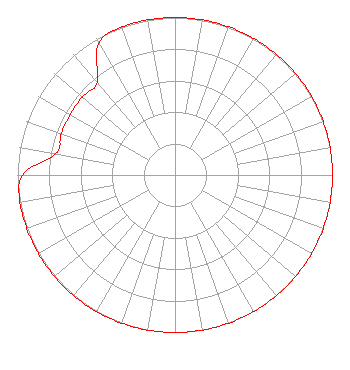 | ||||||||||||||||||
| Azimuth | Ratio | Azimuth | Ratio | Azimuth | Ratio | Azimuth | Ratio | ||||||||||||
| 0 | 1.000 | 10 | 1.000 | 20 | 1.000 | 30 | 1.000 | ||||||||||||
| 40 | 1.000 | 50 | 1.000 | 60 | 1.000 | 70 | 1.000 | ||||||||||||
| 80 | 1.000 | 90 | 1.000 | 100 | 1.000 | 110 | 1.000 | ||||||||||||
| 120 | 1.000 | 130 | 1.000 | 140 | 1.000 | 150 | 1.000 | ||||||||||||
| 160 | 1.000 | 170 | 1.000 | 180 | 1.000 | 190 | 1.000 | ||||||||||||
| 200 | 1.000 | 210 | 1.000 | 220 | 1.000 | 230 | 1.000 | ||||||||||||
| 240 | 1.000 | 250 | 1.000 | 260 | 1.000 | 270 | 0.967 | ||||||||||||
| 280 | 0.768 | 290 | 0.768 | 300 | 0.768 | 310 | 0.768 | ||||||||||||
| 320 | 0.768 | 330 | 0.967 | 340 | 1.000 | 350 | 1.000 | ||||||||||||
Structure Registration Number 1004123 Structure Type: GTOWER Registered To: K2 Towers III, LLC Structure Address: Smith Corners Road (rt. 78) Wethersfield Twp., NY County Name: Wyoming County ASR Issued: 03/06/2023 Date Built: 08/01/1982 Site Elevation: 622.7 m (2043 ft.) Structure Height: 157 m (515 ft.) Height Overall: 157.6 m (517 ft.) Overall Height AMSL: 780.3 m (2560 ft.) FAA Determination: 07/25/2013 FAA Study #: 2013-AEA-3008-OE FAA Circular #: 70/7460-1K Paint & Light FAA Chapters: 3, 4, 5, 12 PRIOR STUDY 1996-AEA-1830-OE 42-37-25.1 N 78-17-20.3 W (NAD 83) 42-37-24.9 N 78-17-21.2 W (Converted to NAD 27) |
2400 Market Street 4th Floor Philadelphia, PA 19103 Phone: 610-660-5610 Limited Liability Company | Date: 01/22/2015 Application Certifier ENTERCOM BUFFALO LICENSE, LLC 401 E. City Avenue Suite 809 Bala Cynwyd, PA 19004 Applicant ERIK C. SWANSON, P.E. Hatfield & Dawson Consulting Engineers, 9500 Greenwood Ave N Seattle, WA 98103 CONSULTING ENGINEER CARRIE A. WARD, ESQ. Entercom Communications Corp. | |||||||||||||||||
| |||||||||||||||||||