
FCCInfo.com
A Service of Cavell, Mertz & Associates, Inc.
(855) FCC-INFO
|
|
W250BQ from 06/23/2004 |
|
|
||||||||||||||||
|
|
W250BQ Channel: 250D 97.9 MHz Newport News, Virginia Service: FX - A translator or application for a translator. Facility ID: 155032 Fac. Service: FX Programming Delivery Method: Unspecified Status: License Application Accepted: 11/08/2012 Application Granted: 12/18/2012 File Number: BLFT-20121108AJK License Expires: 10/01/2027 Prefix Type: This is a license for a translator Application Type: License To Cover FCC Website Links: LMS Facility Details This Application CDBS Application Other W250BQ Applications Other W250BQ Applications in CDBS Including Superseded Applications Mailing Address Correspondence for W250BQ Correspondence related to application BLFT-20121108AJK Service Contour - Open Street Map or USGS Map (60 dBu) Service Contour - KML / Google Earth (60 dBu) Class: D, A Noncommercial educational operating with no more than 10W Site Location: 37-04-42.0 N 76-26-46.0 W (NAD 83) Site Location: 37-04-41.5 N 76-26-47.2 W (Converted to NAD 27) Effective Radiated Power: 0 kW Horiz. ; 0.075 kW Vert. Transmitter Output Power: 0.082 kW Antenna Center HAAT: 124.4 m Horiz.; 0 m Vert. Antenna Center AMSL: 0 m Horiz.; 125 m Vert. Antenna Center HAG: 0 m Horiz.; 116 m Vert. Site Elevation: 9 m. (30 ft.) Height Overall*: 122 m (400 ft.) (* As Filed In This Application, may differ from ASR Data, Below.) Directional Antenna Antenna Make/Model: Electronics Research Inc. 100-1 Antenna ID: 31326 Polarization: H
| ||||||||||||||||||
| Antenna Data for Antenna Id: 31326 W250BQ FX File: BLFT-20121108AJK Electronics Research Inc. - 100-1 Service: FX Pattern and Field Values Include a 10° Clockwise Rotation | 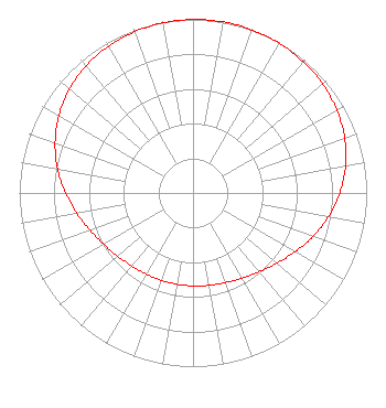 | ||||||||||||||||||
| Azimuth | Ratio | Azimuth | Ratio | Azimuth | Ratio | Azimuth | Ratio | ||||||||||||
| 0 | 0.999 | 10 | 1.000 | 20 | 0.999 | 30 | 0.995 | ||||||||||||
| 40 | 0.987 | 50 | 0.975 | 60 | 0.956 | 70 | 0.929 | ||||||||||||
| 80 | 0.892 | 90 | 0.845 | 100 | 0.792 | 110 | 0.735 | ||||||||||||
| 120 | 0.679 | 130 | 0.630 | 140 | 0.592 | 150 | 0.566 | ||||||||||||
| 160 | 0.549 | 170 | 0.540 | 180 | 0.535 | 190 | 0.534 | ||||||||||||
| 200 | 0.535 | 210 | 0.540 | 220 | 0.549 | 230 | 0.566 | ||||||||||||
| 240 | 0.592 | 250 | 0.630 | 260 | 0.679 | 270 | 0.735 | ||||||||||||
| 280 | 0.792 | 290 | 0.845 | 300 | 0.892 | 310 | 0.929 | ||||||||||||
| 320 | 0.956 | 330 | 0.975 | 340 | 0.987 | 350 | 0.995 | ||||||||||||
Structure Registration Number 1063200 [ASR Heights Differ from W250BQ Application] Structure Type: GTOWER Registered To: American Towers LLC Structure Address: 1008 North Park Lane Hampton, VA County Name: Hampton city ASR Issued: 11/16/2022 Date Built: 12/01/1998 Site Elevation: 7.6 m (25 ft.) Structure Height: 123.4 m (405 ft.) Height Overall: 129.5 m (425 ft.) Overall Height AMSL: 137.1 m (450 ft.) FAA Determination: 11/07/2022 FAA Study #: 2022-AEA-4960-OE FAA Circular #: 70/7460-1L Paint & Light FAA Chapters: 4, 8, 12 OM&L to remain the same as prior study = A MED-DUAL SYSTEM 37-04-42.1 N 76-26-46.4 W (NAD 83) 37-04-41.6 N 76-26-47.6 W (Converted to NAD 27) |
5700 West Oaks Blvd. Rocklin, CA 95765 Phone: 916-251-1600 Not-for-Profit | Date: 11/08/2012 Application Certifier EDUCATIONAL MEDIA FOUNDATION 5700 West Oaks Blvd Rocklin, CA 95765 Applicant SAM WALLINGTON 5700 West Oaks Blvd Rocklin, CA 95765 VP OF ENGINEERING DAVID OXENFORD, ESQ Wilkinson Barker Knauer, Llp 2300 N Street, N.w. Suite 700 Washington, DC 20037 | |||||||||||||||||