
FCCInfo.com
A Service of Cavell, Mertz & Associates, Inc.
(855) FCC-INFO
|
|
|
|
|
||||||||||||||||
|
|
W233CO Channel: 233D 94.5 MHz Gainesville, Georgia Service: FX - A translator or application for a translator. Facility ID: 201525 Fac. Service: FX Programming Delivery Method: Unspecified Status: License Application Accepted: 04/04/2018 Application Granted: 04/23/2018 File Number: BLFT-20180404AAF License Expires: 00/00/0000 Prefix Type: This is a license for a translator Application Type: License To Cover FCC Website Links: LMS Facility Details This Application CDBS Application Other W233CO Applications Other W233CO Applications in CDBS Including Superseded Applications Mailing Address Correspondence for W233CO Correspondence related to application BLFT-20180404AAF Service Contour - Open Street Map or USGS Map (60 dBu) Service Contour - KML / Google Earth (60 dBu) Class: D, A Noncommercial educational operating with no more than 10W Site Location: 34-19-00.7 N 83-49-45.6 W (NAD 83) Site Location: 34-19-00.3 N 83-49-46.0 W (Converted to NAD 27) Effective Radiated Power: 0.25 kW Transmitter Output Power: 0.435 kW Antenna Center HAAT: 0 m Antenna Center AMSL: 512 m (1680 ft.) Antenna Center HAG: 119 m (390 ft.) Site Elevation: 393 m. (1289 ft.) Height Overall*: 124 m (407 ft.) (* As Filed In This Application, may differ from ASR Data, Below.) Directional Antenna Antenna Make/Model: None Antenna ID: 129990 Polarization:
| ||||||||||||||||||
| Antenna Data for Antenna Id: 129990 W233CO FX File: BLFT-20180404AAF None - Service: FX | 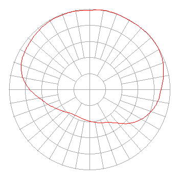 | ||||||||||||||||||
| Azimuth | Ratio | Azimuth | Ratio | Azimuth | Ratio | Azimuth | Ratio | ||||||||||||
| 0 | 0.982 | 10 | 0.999 | 20 | 0.995 | 30 | 0.990 | ||||||||||||
| 40 | 0.996 | 50 | 1.000 | 60 | 0.994 | 70 | 0.971 | ||||||||||||
| 80 | 0.932 | 90 | 0.889 | 100 | 0.860 | 110 | 0.811 | ||||||||||||
| 120 | 0.744 | 130 | 0.656 | 140 | 0.547 | 150 | 0.472 | ||||||||||||
| 160 | 0.443 | 170 | 0.415 | 180 | 0.395 | 190 | 0.378 | ||||||||||||
| 200 | 0.368 | 210 | 0.369 | 220 | 0.384 | 230 | 0.423 | ||||||||||||
| 240 | 0.475 | 250 | 0.545 | 260 | 0.628 | 270 | 0.745 | ||||||||||||
| 280 | 0.840 | 290 | 0.902 | 300 | 0.929 | 310 | 0.945 | ||||||||||||
| 320 | 0.966 | 330 | 0.981 | 340 | 0.986 | 350 | 0.988 | ||||||||||||
Structure Registration Number 1019975 Structure Type: GTOWER Registered To: JWJ PROPERTIES INC Structure Address: 1102 Thompson Bridge Rd Ne Gainesville, GA County Name: Hall County ASR Issued: 06/04/2014 Date Built: 06/16/2015 Site Elevation: 393.2 m (1290 ft.) Structure Height: 123.1 m (404 ft.) Height Overall: 124.1 m (407 ft.) Overall Height AMSL: 517.3 m (1697 ft.) FAA Determination: 06/03/2014 FAA Study #: 2014-ASO-5422-OE FAA Circular #: 70/7460-1K Paint & Light FAA Chapters: 3, 4, 5, 12 34-19-00.7 N 83-49-45.6 W (NAD 83) 34-19-00.3 N 83-49-46.0 W (Converted to NAD 27) |
P.o. Box 10 Gainesville, GA 30503 Phone: 770-532-9921 | Date: 04/04/2018 Application Certifier JACOBS MEDIA CORPORATION P.o. Box 10 Gainesville, GA 30503 Applicant SANDY GRIFFIN 1102 Thompson Bridge Road Gainesville, GA 30501 CHIEF ENGINEER HOWARD LIBERMAN Wilkinson Barker Knauer, Llp 1800 M Street, N.w. Suite 800n Washington, DC 20036 | |||||||||||||||||