
FCCInfo.com
A Service of Cavell, Mertz & Associates, Inc.
(855) FCC-INFO
|
|
WKXS-FM from 04/01/1994 WKXS-FM from 02/11/1994 |
|  |
|
|||||||||||||||
|
|
WKXS-FM Channel: 233A 94.5 MHz Leland, North Carolina Service: FM - A full-service FM station or application. Facility ID: 25998 Fac. Service: FM Status: License 73.215 Station Application Accepted: 04/03/2006 Application Granted: 04/14/2006 File Number: BLH-20060403BWN License Expires: 00/00/0000 Prefix Type: This is a license for a commercial FM station Application Type: License To Cover FCC Website Links: LMS Facility Details This Application CDBS Application Other WKXS-FM Applications Other WKXS-FM Applications in CDBS Including Superseded Applications Mailing Address Correspondence for WKXS-FM Correspondence related to application BLH-20060403BWN Service Contour - Open Street Map or USGS Map (60 dBu) Service Contour - KML / Google Earth (60 dBu) Public Inspection Files Facility Type: FM STATION Class: A, A Zone I; I-A; or II station; with 0.1kW-6kW ERP and a class contour distance <=28km Site Location: 34-12-35.6 N 77-56-52.0 W (NAD 83) Site Location: 34-12-35.0 N 77-56-53.0 W (Converted to NAD 27) Effective Radiated Power: 3.8 kW Transmitter Output Power: 3.595 kW Antenna Center HAAT: 126.7 m (416 ft.) Antenna Center AMSL: 130.6 m (428 ft.) Antenna Center HAG: 127.6 m (419 ft.) Calculated Site Elevation: 3 m. (10 ft.) Height Overall*: 134.1 m (440 ft.) (* As Filed In This Application, may differ from ASR Data, Below.) Directional Antenna Antenna Make/Model: Electronics Research Inc. LP-2E-DA-HW two sections half-wave length spaced Antenna ID: 70970 Polarization: | ||||||||||||||||||
| Antenna Data for Antenna Id: 70970 WKXS-FM FM File: BLH-20060403BWN Electronics Research Inc. - LP-2E-DA-HW two sections half-wave length spaced Service: FM | 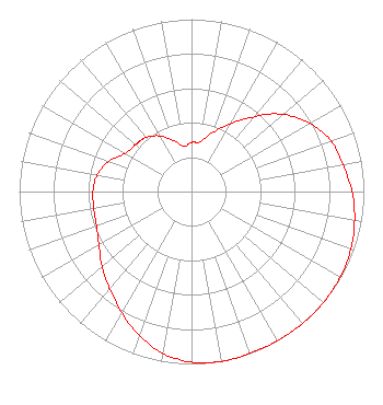 | ||||||||||||||||||
| Azimuth | Ratio | Azimuth | Ratio | Azimuth | Ratio | Azimuth | Ratio | ||||||||||||
| 0 | 0.285 | 10 | 0.293 | 20 | 0.365 | 30 | 0.454 | ||||||||||||
| 40 | 0.561 | 45 | 0.636 | 50 | 0.701 | 60 | 0.794 | ||||||||||||
| 70 | 0.860 | 80 | 0.891 | 90 | 0.931 | 100 | 0.961 | ||||||||||||
| 110 | 0.983 | 120 | 0.996 | 130 | 1.000 | 135 | 1.000 | ||||||||||||
| 140 | 1.000 | 150 | 0.999 | 160 | 0.999 | 170 | 1.000 | ||||||||||||
| 180 | 0.990 | 190 | 0.953 | 200 | 0.888 | 210 | 0.811 | ||||||||||||
| 220 | 0.740 | 225 | 0.707 | 230 | 0.675 | 240 | 0.620 | ||||||||||||
| 250 | 0.587 | 260 | 0.575 | 270 | 0.572 | 280 | 0.556 | ||||||||||||
| 290 | 0.511 | 300 | 0.443 | 310 | 0.424 | 315 | 0.418 | ||||||||||||
| 320 | 0.409 | 330 | 0.373 | 340 | 0.317 | 350 | 0.265 | ||||||||||||
Structure Registration Number 1006096 Structure Type: TOWER Registered To: BEACON COMMUNICATIONS INC Structure Address: 1806 Burnett Blvd Wilmington, NC County Name: New Hanover County ASR Issued: 04/08/1997 Date Built: 01/01/1976 Site Elevation: 3 m (10 ft.) Structure Height: 131.6 m (432 ft.) Height Overall: 134.1 m (440 ft.) Overall Height AMSL: 137.1 m (450 ft.) FAA Determination: 12/15/1976 FAA Study #: 76-SO-354-OE Paint & Light FAA Chapters: 1, 3, 12, 21 RED LIGHTS/PAINT 34-12-36.0 N 77-56-52.0 W (NAD 83) 34-12-35.4 N 77-56-53.0 W (Converted to NAD 27) |
780 Johnson Ferry Road Suite 500 Atlanta, GA 30342 Phone: 404-949-0700 Limited Liability Company | Date: 04/03/2006 Application Certifier CUMULUS LICENSING LLC 3535 Piedmont Road Building 14, Suite 1400 Atlanta, GA 30305-4601 Applicant JEFFERSON G. BROCK Graham Brock, Inc. P.o. Box 24466 St. Simons Island, GA 31522-7466 TECHNICAL CONSULTANT MARK N. LIPP, ESQ Vinson & Elkins, Llp | |||||||||||||||||
| |||||||||||||||||||