
FCCInfo.com
A Service of Cavell, Mertz & Associates, Inc.
(855) FCC-INFO
|
|
K284CG from 08/19/2016 K284CG from 02/11/2016 K284CG from 04/29/2013 |
|
|
||||||||||||||||
|
|
K284CG Channel: 284D 104.7 MHz Olympia, Washington Service: FX - A translator or application for a translator. Facility ID: 146604 Fac. Service: FX Programming Delivery Method: Unspecified Status: License Application Accepted: 07/17/2017 Application Granted: 07/28/2017 File Number: BLFT-20170717ADC License Expires: 00/00/0000 Prefix Type: This is a license for a translator Application Type: License To Cover FCC Website Links: LMS Facility Details This Application CDBS Application Other K284CG Applications Other K284CG Applications in CDBS Including Superseded Applications Mailing Address Correspondence for K284CG Correspondence related to application BLFT-20170717ADC Service Contour - Open Street Map or USGS Map (60 dBu) Service Contour - KML / Google Earth (60 dBu) Class: D, A Noncommercial educational operating with no more than 10W Site Location: 47-00-19.4 N 122-56-39.5 W (NAD 83) Site Location: 47-00-20.1 N 122-56-35.0 W (Converted to NAD 27) Effective Radiated Power: 0.07 kW Transmitter Output Power: 0.2 kW Antenna Center HAAT: 0 m Antenna Center AMSL: 189 m (620 ft.) Antenna Center HAG: 37 m (121 ft.) Site Elevation: 152 m. (499 ft.) Height Overall*: 46 m (151 ft.) (* As Filed In This Application, may differ from ASR Data, Below.) Directional Antenna Antenna Make/Model: None Antenna ID: 127664 Polarization:
| ||||||||||||||||||
| Antenna Data for Antenna Id: 127664 K284CG FX File: BLFT-20170717ADC None - Service: FX Pattern and Field Values Include a 90° Clockwise Rotation | 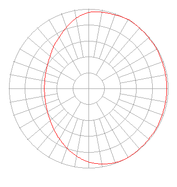 | ||||||||||||||||||
| Azimuth | Ratio | Azimuth | Ratio | Azimuth | Ratio | Azimuth | Ratio | ||||||||||||
| 0 | 0.953 | 10 | 0.973 | 20 | 0.983 | 30 | 1.000 | ||||||||||||
| 40 | 0.992 | 50 | 0.988 | 60 | 0.988 | 70 | 0.983 | ||||||||||||
| 80 | 0.983 | 90 | 0.983 | 100 | 0.983 | 110 | 0.983 | ||||||||||||
| 120 | 0.988 | 130 | 0.988 | 140 | 0.992 | 150 | 1.000 | ||||||||||||
| 160 | 0.991 | 170 | 0.963 | 180 | 0.923 | 190 | 0.862 | ||||||||||||
| 200 | 0.797 | 210 | 0.731 | 220 | 0.676 | 230 | 0.628 | ||||||||||||
| 240 | 0.594 | 250 | 0.571 | 260 | 0.558 | 270 | 0.553 | ||||||||||||
| 280 | 0.558 | 290 | 0.571 | 300 | 0.594 | 310 | 0.628 | ||||||||||||
| 320 | 0.682 | 330 | 0.738 | 340 | 0.815 | 350 | 0.897 | ||||||||||||
Structure Registration Number 1050704 Structure Type: TOWER Registered To: WHISLER, J B DBA = WHISLER COMMUNICATIONS Structure Address: Bush Mt. 1.8 Miles Wsw Of Olympia Tumwater, WA County Name: Thurston County ASR Issued: 06/19/1998 Date Built: 06/01/1998 Site Elevation: 152.4 m (500 ft.) Structure Height: 42.7 m (140 ft.) Height Overall: 45.7 m (150 ft.) Overall Height AMSL: 198.1 m (650 ft.) FAA Determination: 01/20/1998 FAA Study #: 98-ANM-0018-OE FAA Circular #: 70/7460-1J Paint & Light FAA Chapters: 4, 5, 13 47-00-19.0 N 122-56-40.0 W (NAD 83) 47-00-19.7 N 122-56-35.5 W (Converted to NAD 27) |
Post Office Box 2482 Kirkland, WA 98083 Phone: 425-867-2340 | Date: 07/17/2017 Application Certifier SACRED HEART RADIO, INC. Po Box 2482 Kirkland, WA 98083 Applicant RONALD R. BELTER Po Box 2482 Kirkland, WA 98083 PRESIDENT DENNIS J. KELLY Law Office Of Dennis J. Kelly Post Office Box 41177 Washington, DC 20018-0577 | |||||||||||||||||