
FCCInfo.com
A Service of Cavell, Mertz & Associates, Inc.
(855) FCC-INFO
|
|
K218DU from 02/26/1996 |
|
|
||||||||||||||||
|
|
K218DU Channel: 218D 91.5 MHz Ridgecrest, California Service: FX - A translator or application for a translator. Facility ID: 8434 Fac. Service: FX Programming Delivery Method: Unspecified Status: License Application Accepted: 10/11/2005 Application Granted: 12/20/2005 File Number: BLFT-20051011ABZ License Expires: 00/00/0000 Prefix Type: This is a license for a translator Application Type: License To Cover FCC Website Links: LMS Facility Details This Application CDBS Application Other K218DU Applications Other K218DU Applications in CDBS Including Superseded Applications Mailing Address Correspondence for K218DU Correspondence related to application BLFT-20051011ABZ Service Contour - Open Street Map or USGS Map (60 dBu) Service Contour - KML / Google Earth (60 dBu) Class: D, A Noncommercial educational operating with no more than 10W Site Location: 35-37-29.8 N 117-43-20.2 W (NAD 83) Site Location: 35-37-30.0 N 117-43-17.0 W (Converted to NAD 27) Effective Radiated Power: 0 kW Horiz. ; 0.038 kW Vert. Transmitter Output Power: 0.018 kW Antenna Center HAAT: 0 m Horiz.; -38.2 m Vert. Antenna Center AMSL: 0 m Horiz.; 741 m Vert. Antenna Center HAG: 0 m Horiz.; 9 m Vert. Site Elevation: 732 m. (2402 ft.) Height Overall*: 16 m (52 ft.) (* As Filed In This Application, may differ from ASR Data, Below.) Directional Antenna Antenna Make/Model: None Antenna ID: 16130 Polarization:
| ||||||||||||||||||
| Antenna Data for Antenna Id: 16130 K218DU FX File: BLFT-20051011ABZ None - Service: FX Pattern and Field Values Include a 90° Clockwise Rotation | 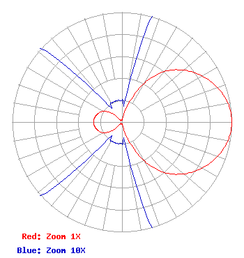 | ||||||||||||||||||
| Azimuth | Ratio | Azimuth | Ratio | Azimuth | Ratio | Azimuth | Ratio | ||||||||||||
| 0 | 0.020 | 10 | 0.030 | 20 | 0.185 | 30 | 0.410 | ||||||||||||
| 40 | 0.600 | 50 | 0.735 | 60 | 0.840 | 70 | 0.923 | ||||||||||||
| 80 | 0.980 | 90 | 1.000 | 100 | 0.980 | 110 | 0.923 | ||||||||||||
| 120 | 0.840 | 130 | 0.735 | 140 | 0.600 | 150 | 0.410 | ||||||||||||
| 160 | 0.185 | 170 | 0.030 | 180 | 0.020 | 190 | 0.020 | ||||||||||||
| 200 | 0.020 | 210 | 0.020 | 220 | 0.025 | 230 | 0.125 | ||||||||||||
| 240 | 0.195 | 250 | 0.230 | 260 | 0.250 | 270 | 0.260 | ||||||||||||
| 280 | 0.250 | 290 | 0.230 | 300 | 0.195 | 310 | 0.125 | ||||||||||||
| 320 | 0.025 | 330 | 0.020 | 340 | 0.020 | 350 | 0.020 | ||||||||||||
Structure Registration Number 1051936 Structure Type: TOWER Registered To: KITCHEN PRODUCTIONS INC DBA = TORTOISE COMMUNICATIONS Structure Address: 216 N Jacks Ranch Rd Ridgecrest, CA County Name: Kern County ASR Issued: 07/02/1998 Date Built: 05/01/1998 Site Elevation: 731.6 m (2400 ft.) Structure Height: 9 m (30 ft.) Height Overall: 16 m (52 ft.) Overall Height AMSL: 747.6 m (2453 ft.) FAA Determination: 05/18/1998 FAA Study #: 98-AWP-1482-OE Paint & Light FAA Chapters: NONE 35-37-30.0 N 117-43-20.0 W (NAD 83) 35-37-30.2 N 117-43-16.8 W (Converted to NAD 27) |
P.o. Box 391 4002 N. 3300 E. Twin Falls, ID 83303 Phone: 208-733-3133 | Date: 10/11/2005 Application Certifier CALVARY CHAPEL OF TWIN FALLS, INC. 4002 N. 3300 E. Twin Falls, ID 83301 Applicant LOIS MILLS 4002 N. 3300 E. Twin Falls, ID 83301 APPLICATIONS TECHNICIAN CARY S. TEPPER, ESQ Booth, Freret, Imlay & Tepper, P.c. 7900 Wisconsin Ave Bethesda, MD 20814 | |||||||||||||||||