
FCCInfo.com
A Service of Cavell, Mertz & Associates, Inc.
(855) FCC-INFO
|
|
W295BW from 09/20/2012 W295BW from 07/24/2000 |
|
|
||||||||||||||||
|
|
W295BW Channel: 295D 106.9 MHz Grand Island, New York Service: FX - A translator or application for a translator. Facility ID: 92807 Fac. Service: FX Programming Delivery Method: Unspecified Status: License Application Accepted: 10/14/2016 Application Granted: 10/28/2016 File Number: BLFT-20161014AAS License Expires: 00/00/0000 Prefix Type: This is a license for a translator Application Type: License To Cover FCC Website Links: LMS Facility Details This Application CDBS Application Other W295BW Applications Other W295BW Applications in CDBS Including Superseded Applications Mailing Address Correspondence for W295BW Correspondence related to application BLFT-20161014AAS Service Contour - Open Street Map or USGS Map (60 dBu) Service Contour - KML / Google Earth (60 dBu) Class: D, A Noncommercial educational operating with no more than 10W Site Location: 43-01-48.2 N 78-55-14.1 W (NAD 83) Site Location: 43-01-48.0 N 78-55-15.0 W (Converted to NAD 27) Effective Radiated Power: 0.15 kW Transmitter Output Power: 0.157 kW Antenna Center HAAT: 0 m Antenna Center AMSL: 214 m (702 ft.) Antenna Center HAG: 38 m (125 ft.) Site Elevation: 176 m. (577 ft.) Height Overall*: 346 m (1135 ft.) (* As Filed In This Application, may differ from ASR Data, Below.) Directional Antenna Antenna Make/Model: None Antenna ID: 125681 Polarization:
| ||||||||||||||||||
| Antenna Data for Antenna Id: 125681 W295BW FX File: BLFT-20161014AAS None - Service: FX Pattern and Field Values Include a 50° Clockwise Rotation | 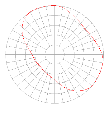 | ||||||||||||||||||
| Azimuth | Ratio | Azimuth | Ratio | Azimuth | Ratio | Azimuth | Ratio | ||||||||||||
| 0 | 1.000 | 10 | 0.970 | 20 | 0.910 | 30 | 0.860 | ||||||||||||
| 40 | 0.830 | 50 | 0.810 | 60 | 0.830 | 70 | 0.860 | ||||||||||||
| 80 | 0.910 | 90 | 0.970 | 100 | 1.000 | 110 | 1.000 | ||||||||||||
| 120 | 1.000 | 130 | 1.000 | 140 | 0.950 | 150 | 0.860 | ||||||||||||
| 160 | 0.750 | 170 | 0.610 | 180 | 0.520 | 190 | 0.460 | ||||||||||||
| 200 | 0.430 | 210 | 0.410 | 220 | 0.390 | 230 | 0.380 | ||||||||||||
| 240 | 0.390 | 250 | 0.410 | 260 | 0.430 | 270 | 0.460 | ||||||||||||
| 280 | 0.520 | 290 | 0.620 | 300 | 0.750 | 310 | 0.860 | ||||||||||||
| 320 | 0.950 | 330 | 1.000 | 340 | 1.000 | 350 | 1.000 | ||||||||||||
Structure Registration Number 1033433 Structure Type: TOWER Registered To: Western New York Public Broadcasting Assocation Structure Address: 871 Whitehaven Rd Grand Island, NY County Name: Erie County ASR Issued: 01/31/2007 Date Built: 01/01/1986 Site Elevation: 175.9 m (577 ft.) Structure Height: 325.5 m (1068 ft.) Height Overall: 345.6 m (1134 ft.) Overall Height AMSL: 521.5 m (1711 ft.) FAA Determination: 01/30/2007 FAA Study #: 2007-AEA-228-OE FAA Circular #: 70/7460-1K Paint & Light FAA Chapters: 4, 7, 12 PRIOR STUDY 1999-AEA-3534-OE 43-01-48.2 N 78-55-14.1 W (NAD 83) 43-01-48.0 N 78-55-15.0 W (Converted to NAD 27) |
2207 Concord Pike Box 269 Wilmington, DE 19803 Phone: 302-540-5690 | Date: 10/14/2016 Application Certifier PRIORITY RADIO, INC. 2207 Concord Pike Box 269 Wilmington, DE 19803 Applicant CARY S. TEPPER 4900 Auburn Avenue Suite 100 Bethesda, MD 20814-2632 COMMUNICATIONS COUNSEL CARY S. TEPPER, ESQ. Tepper Law Firm, Llc 4900 Auburn Avenue Suite 100 Bethesda, MD 20814-2632 | |||||||||||||||||