
FCCInfo.com
A Service of Cavell, Mertz & Associates, Inc.
(855) FCC-INFO
|
|
|
|
|
||||||||||||||||
|
|
K245AA Channel: 245D 96.9 MHz Eugene, Oregon Service: FX - A translator or application for a translator. Facility ID: 839 Fac. Service: FX Programming Delivery Method: Unspecified Status: License Application Accepted: 10/03/1997 Application Granted: 11/05/1998 File Number: BLFT-19971003TJ License Expires: 00/00/0000 Prefix Type: This is a license for a translator Application Type: License To Cover FCC Website Links: LMS Facility Details This Application CDBS Application Other K245AA Applications Other K245AA Applications in CDBS Including Superseded Applications Mailing Address Correspondence for K245AA Correspondence related to application BLFT-19971003TJ Service Contour - Open Street Map or USGS Map (60 dBu) Service Contour - KML / Google Earth (60 dBu) Class: D, A Noncommercial educational operating with no more than 10W Site Location: 44-00-10.5 N 123-06-52.3 W (NAD 83) Site Location: 44-00-11.1 N 123-06-48.0 W (Converted to NAD 27) Effective Radiated Power: 0 kW Horiz. ; 0.25 kW Vert. Antenna Center HAAT: 0 m Horiz.; 279 m Vert. Antenna Center AMSL: 0 m Horiz.; 479 m Vert. Antenna Center HAG: 0 m Horiz.; 92 m Vert. Calculated Site Elevation: m. Height Overall*: 122 m (400 ft.) (* As Filed In This Application, may differ from ASR Data, Below.) Directional Antenna Antenna Make/Model: None Antenna ID: 14832 Polarization:
| ||||||||||||||||||
| Antenna Data for Antenna Id: 14832 K245AA FX File: BLFT-19971003TJ None - Service: FX | 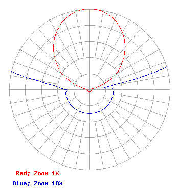 | ||||||||||||||||||
| Azimuth | Ratio | Azimuth | Ratio | Azimuth | Ratio | Azimuth | Ratio | ||||||||||||
| 0 | 1.000 | 10 | 0.980 | 20 | 0.915 | 30 | 0.815 | ||||||||||||
| 40 | 0.685 | 50 | 0.537 | 60 | 0.380 | 70 | 0.170 | ||||||||||||
| 80 | 0.030 | 90 | 0.030 | 100 | 0.030 | 110 | 0.030 | ||||||||||||
| 120 | 0.030 | 130 | 0.030 | 140 | 0.030 | 150 | 0.030 | ||||||||||||
| 160 | 0.030 | 170 | 0.030 | 180 | 0.030 | 190 | 0.030 | ||||||||||||
| 200 | 0.030 | 210 | 0.030 | 220 | 0.030 | 230 | 0.030 | ||||||||||||
| 240 | 0.030 | 250 | 0.030 | 260 | 0.030 | 270 | 0.030 | ||||||||||||
| 280 | 0.070 | 290 | 0.210 | 300 | 0.400 | 310 | 0.550 | ||||||||||||
| 320 | 0.695 | 330 | 0.820 | 340 | 0.918 | 350 | 0.980 | ||||||||||||
Structure Registration Number 1041578 [ASR Heights Differ from K245AA Application] Structure Type: GTOWER Registered To: VB-S1 Assets, LLC Structure Address: 4565 Blanton Rd (us-or-5012) Eugene, OR County Name: Lane County ASR Issued: 01/30/2018 Date Built: 01/01/1989 Site Elevation: 387.1 m (1270 ft.) Structure Height: 124.4 m (408 ft.) Height Overall: 124.4 m (408 ft.) Overall Height AMSL: 511.5 m (1678 ft.) FAA Determination: 03/14/2017 FAA Study #: 2017-ANM-284-OE FAA Circular #: 70/7460-1L Paint & Light FAA Chapters: 4, 8, 12 Removed expiration date from determination. Scenario 1./jjs/case#635066 44-00-09.5 N 123-06-48.6 W (NAD 83) 44-00-10.1 N 123-06-44.3 W (Converted to NAD 27) |
Po Box 278 Albany, OR 97321 Phone: 541-730-3006 Corporation | Date: 10/03/1997 Application Certifier ALBANY RADIO CORPORATION Albany Radio Corporation Post Office Box 278 Albany, OR 97321 Applicant | |||||||||||||||||