
FCCInfo.com
A Service of Cavell, Mertz & Associates, Inc.
(855) FCC-INFO
|
|
|
|  |
|
|||||||||||||||
|
|
WHKR Channel: 274C2 102.7 MHz Rockledge, Florida Service: FM - A full-service FM station or application. Facility ID: 57628 Fac. Service: FM Status: License 73.215 Station Application Accepted: 10/15/2002 Application Granted: 11/06/2002 File Number: BLH-20021015ACD License Expires: 00/00/0000 Prefix Type: This is a license for a commercial FM station Application Type: License To Cover FCC Website Links: LMS Facility Details This Application CDBS Application Other WHKR Applications Other WHKR Applications in CDBS Including Superseded Applications Mailing Address Correspondence for WHKR Correspondence related to application BLH-20021015ACD Service Contour - Open Street Map or USGS Map (60 dBu) Service Contour - KML / Google Earth (60 dBu) Public Inspection Files Facility Type: FM STATION Class: C2, A Zone II station; with 25kW-50kW ERP and a class contour distance 39km-52km Site Location: 28-21-00.0 N 80-46-28.2 W (NAD 83) Site Location: 28-20-59.0 N 80-46-29.0 W (Converted to NAD 27) Effective Radiated Power: 50 kW Transmitter Output Power: 18 kW Antenna Center HAAT: 132 m (433 ft.) Antenna Center AMSL: 134 m (440 ft.) Antenna Center HAG: 128 m (420 ft.) Site Elevation: 6 m. (20 ft.) Height Overall*: 137 m (449 ft.) (* As Filed In This Application, may differ from ASR Data, Below.) Directional Antenna Antenna Make/Model: Jampro JCPD-2/2(4)DA Antenna ID: 44923 Polarization: | ||||||||||||||||||
| Antenna Data for Antenna Id: 44923 WHKR FM File: BLH-20021015ACD Jampro - JCPD-2/2(4)DA Service: FM | 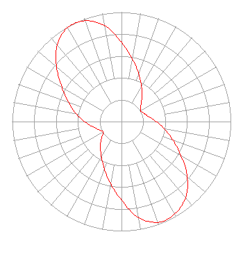 | ||||||||||||||||||
| Azimuth | Ratio | Azimuth | Ratio | Azimuth | Ratio | Azimuth | Ratio | ||||||||||||
| 0 | 0.725 | 10 | 0.578 | 20 | 0.460 | 30 | 0.366 | ||||||||||||
| 40 | 0.291 | 50 | 0.232 | 60 | 0.200 | 70 | 0.220 | ||||||||||||
| 80 | 0.253 | 90 | 0.318 | 100 | 0.399 | 110 | 0.501 | ||||||||||||
| 120 | 0.630 | 130 | 0.785 | 140 | 0.910 | 150 | 0.975 | ||||||||||||
| 160 | 0.980 | 170 | 0.890 | 180 | 0.720 | 190 | 0.577 | ||||||||||||
| 200 | 0.460 | 210 | 0.370 | 220 | 0.300 | 230 | 0.240 | ||||||||||||
| 240 | 0.194 | 250 | 0.220 | 260 | 0.270 | 270 | 0.338 | ||||||||||||
| 280 | 0.425 | 290 | 0.520 | 300 | 0.630 | 310 | 0.775 | ||||||||||||
| 320 | 0.915 | 330 | 0.990 | 340 | 0.980 | 350 | 0.890 | ||||||||||||
Structure Registration Number 1030922 [ASR Heights Differ from WHKR Application] Structure Type: GTOWER Registered To: American Towers LLC Structure Address: 2705 Parrish Rd (075127 / Cocoa Parrish) Cocoa, FL County Name: Brevard County ASR Issued: 08/17/2021 Date Built: 02/04/2004 Site Elevation: 5.4 m (18 ft.) Structure Height: 131 m (430 ft.) Height Overall: 135 m (443 ft.) Overall Height AMSL: 140.4 m (461 ft.) FAA Determination: 08/05/2021 FAA Study #: 2021-ASO-29228-OE FAA Circular #: 70/7460-1M Paint & Light FAA Chapters: 4, 8, 15 PRIOR STUDY 2003-ASO-5091-OE 28-21-00.6 N 80-46-27.8 W (NAD 83) 28-20-59.6 N 80-46-28.6 W (Converted to NAD 27) |
780 Johnson Ferry Road Suite 500 Atlanta, GA 30342 Phone: 404-949-0700 Limited Liability Company | Date: 10/15/2002 Application Certifier CUMULUS LICENSING CORP. Cumulus Licensing Corp. 3535 Piedmont Road Building 14, 14th Floor Atlanta, GA 30305 Applicant VIRGLE LEON STRICKLAND 12585 Old Highway 280 East Suite 102 Chelsea, AL 35043 TECHNICAL CONSULTANT MARK N. LIPP, ESQ. Shook, Hardy & Bacon L.l.p. | |||||||||||||||||