
FCCInfo.com
A Service of Cavell, Mertz & Associates, Inc.
(855) FCC-INFO
|
|
WMXT from 02/07/1990 |
|  |
|
|||||||||||||||
|
|
WMXT Channel: 271C2 102.1 MHz Pamplico, South Carolina Service: FM - A full-service FM station or application. Facility ID: 51420 Fac. Service: FM Status: License 73.215 Station Application Accepted: 06/01/2009 Application Granted: 06/03/2009 File Number: BMLH-20090601AKJ License Expires: 00/00/0000 Prefix Type: This is a modification of a license for a commecial FM station Application Type: Minor Modification FCC Website Links: LMS Facility Details This Application CDBS Application Other WMXT Applications Other WMXT Applications in CDBS Including Superseded Applications Mailing Address Correspondence for WMXT Correspondence related to application BMLH-20090601AKJ Service Contour - Open Street Map or USGS Map (60 dBu) Service Contour - KML / Google Earth (60 dBu) Public Inspection Files Facility Type: FM STATION Class: C2, A Zone II station; with 25kW-50kW ERP and a class contour distance 39km-52km Site Location: 33-58-36.6 N 79-48-31.2 W (NAD 83) Site Location: 33-58-36.0 N 79-48-32.0 W (Converted to NAD 27) Effective Radiated Power: 50 kW Horiz. ; 49.4 kW Vert. Transmitter Output Power: 12.47 kW Antenna Center HAAT: 146 m (479 ft.) Antenna Center AMSL: 174 m (571 ft.) Antenna Center HAG: 145 m (476 ft.) Site Elevation: 29 m. (95 ft.) Height Overall*: 152 m (499 ft.) (* As Filed In This Application, may differ from ASR Data, Below.) Directional Antenna Antenna Make/Model: Shivley 6810-5-DA Antenna ID: 14662 Polarization: | ||||||||||||||||||
| Antenna Data for Antenna Id: 14662 WMXT FM File: BMLH-20090601AKJ Shivley - 6810-5-DA Service: FM | 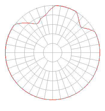 | ||||||||||||||||||
| Azimuth | Ratio | Azimuth | Ratio | Azimuth | Ratio | Azimuth | Ratio | ||||||||||||
| 0 | 0.945 | 5 | 1.000 | 10 | 1.000 | 20 | 1.000 | ||||||||||||
| 30 | 1.000 | 31 | 0.986 | 35 | 0.934 | 40 | 0.872 | ||||||||||||
| 45 | 0.823 | 50 | 0.823 | 60 | 0.945 | 65 | 1.000 | ||||||||||||
| 70 | 1.000 | 80 | 1.000 | 90 | 1.000 | 100 | 1.000 | ||||||||||||
| 110 | 1.000 | 120 | 1.000 | 130 | 1.000 | 140 | 1.000 | ||||||||||||
| 150 | 1.000 | 160 | 1.000 | 170 | 1.000 | 180 | 1.000 | ||||||||||||
| 190 | 1.000 | 200 | 1.000 | 210 | 1.000 | 220 | 1.000 | ||||||||||||
| 230 | 1.000 | 240 | 1.000 | 250 | 1.000 | 260 | 1.000 | ||||||||||||
| 270 | 1.000 | 280 | 1.000 | 290 | 1.000 | 300 | 1.000 | ||||||||||||
| 305 | 1.000 | 310 | 0.945 | 320 | 0.814 | 330 | 0.701 | ||||||||||||
| 335 | 0.701 | 340 | 0.751 | 350 | 0.814 | ||||||||||||||
Structure Registration Number 1268215 Structure Type: TOWER Registered To: VB Nimbus, LLC Structure Address: Mcallister Mill Rd; 0.18 Mi. Sse Of Intersection Of Mcallister Mill & Ivey Rds. Scranton, SC County Name: Florence County ASR Issued: 10/13/2020 Date Built: 04/26/1995 Site Elevation: 29 m (95 ft.) Structure Height: 151.2 m (496 ft.) Height Overall: 152.1 m (499 ft.) Overall Height AMSL: 181.1 m (594 ft.) FAA Determination: 05/01/2009 FAA Study #: 2009-ASO-1946-OE Paint & Light FAA Chapters: A2, H Continue As Is OM&L = 24-HR MED-STROBES 33-58-36.2 N 79-48-31.3 W (NAD 83) 33-58-35.6 N 79-48-32.1 W (Converted to NAD 27) |
780 Johnson Ferry Road Suite 500 Atlanta, GA 30342 Phone: 404-949-0700 Limited Liability Company | Date: 06/01/2009 Application Certifier CUMULUS LICENSING LLC 3280 Peachtree Road Nw Suite 2300 Atlanta, GA 30305 Applicant JEFFERSON G. BROCK Graham Brock, Inc. P. O. Box 24466 St. Simons Island, GA 31522-7466 TECHNICAL CONSULTANT MARK N. LIPP, ESQ. Wiley Rein Llp | |||||||||||||||||
| |||||||||||||||||||