
FCCInfo.com
A Service of Cavell, Mertz & Associates, Inc.
(855) FCC-INFO
|
|
|
|
|
||||||||||||||||
|
|
W252CT Channel: 252D 98.3 MHz Bangor, Maine Service: FX - A translator or application for a translator. Facility ID: 145024 Fac. Service: FX Programming Delivery Method: Unspecified Status: License Application Accepted: 09/29/2014 Application Granted: 12/08/2014 File Number: BLFT-20140929AME License Expires: 00/00/0000 Prefix Type: This is a license for a translator Application Type: License To Cover FCC Website Links: LMS Facility Details This Application CDBS Application Other W252CT Applications Other W252CT Applications in CDBS Including Superseded Applications Mailing Address Correspondence for W252CT Correspondence related to application BLFT-20140929AME Service Contour - Open Street Map or USGS Map (60 dBu) Service Contour - KML / Google Earth (60 dBu) Class: D, A Noncommercial educational operating with no more than 10W Site Location: 44-49-47.3 N 68-47-03.1 W (NAD 83) Site Location: 44-49-47.0 N 68-47-05.0 W (Converted to NAD 27) Effective Radiated Power: 0.25 kW Transmitter Output Power: 0.875 kW Antenna Center HAAT: 124.8 m Horiz.; 0 m Vert. Antenna Center AMSL: 171 m (561 ft.) Antenna Center HAG: 100 m (328 ft.) Site Elevation: 71 m. (233 ft.) Height Overall*: 123 m (404 ft.) (* As Filed In This Application, may differ from ASR Data, Below.) Directional Antenna Antenna Make/Model: None Antenna ID: 115107 Polarization:
| ||||||||||||||||||
| Antenna Data for Antenna Id: 115107 W252CT FX File: BLFT-20140929AME None - Service: FX | 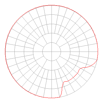 | ||||||||||||||||||
| Azimuth | Ratio | Azimuth | Ratio | Azimuth | Ratio | Azimuth | Ratio | ||||||||||||
| 0 | 1.000 | 10 | 1.000 | 20 | 1.000 | 30 | 1.000 | ||||||||||||
| 40 | 1.000 | 50 | 1.000 | 60 | 1.000 | 70 | 1.000 | ||||||||||||
| 80 | 1.000 | 90 | 1.000 | 100 | 1.000 | 110 | 0.900 | ||||||||||||
| 120 | 0.730 | 130 | 0.730 | 140 | 0.730 | 150 | 0.730 | ||||||||||||
| 160 | 0.730 | 170 | 1.000 | 180 | 1.000 | 190 | 1.000 | ||||||||||||
| 200 | 1.000 | 210 | 1.000 | 220 | 1.000 | 230 | 1.000 | ||||||||||||
| 240 | 1.000 | 250 | 1.000 | 260 | 1.000 | 270 | 1.000 | ||||||||||||
| 280 | 1.000 | 290 | 1.000 | 300 | 1.000 | 310 | 1.000 | ||||||||||||
| 320 | 1.000 | 330 | 1.000 | 340 | 1.000 | 350 | 1.000 | ||||||||||||
Structure Registration Number 1248207 Structure Type: Registered To: Zone Corporation Structure Address: 861 Broadway Bangor, ME County Name: Penobscot County ASR Issued: 04/26/2005 Date Built: 12/05/1937 Site Elevation: 70.7 m (232 ft.) Structure Height: 123.1 m (404 ft.) Height Overall: 123.1 m (404 ft.) Overall Height AMSL: 193.8 m (636 ft.) FAA Determination: 02/13/1989 FAA Study #: NOS20-0022 Paint & Light FAA Chapters: 1, 3, 12, 21 RED LIGHTS/PAINT. TOWER 1 OF 2 TOWER ARRAY. 44-49-47.0 N 68-47-03.0 W (NAD 83) 44-49-46.7 N 68-47-04.9 W (Converted to NAD 27) |
Po Box 1929 Bangor, ME 04402 Phone: 207-990-2800 | Date: 09/29/2014 Application Certifier ZONE CORPORATION Po Box 1929 Bangor, ME 04402-1929 Applicant HOWARD L. SOULE Po Box 1929 Bangor, ME 04402 DIRECTOR OF ENGINEERING ZONE CORPORATION Zone Corporation Po Box 1929 Bangor, ME 04402-1929 | |||||||||||||||||