
FCCInfo.com
A Service of Cavell, Mertz & Associates, Inc.
(855) FCC-INFO
|
|
|
|
|
||||||||||||||||
|
|
WAYV Channel: 236B 95.1 MHz Atlantic City, New Jersey Service: FM - A full-service FM station or application. Facility ID: 3125 Fac. Service: FM Status: License Application Accepted: 11/08/2001 Application Granted: 04/11/2002 File Number: BMLH-20011108AAC License Expires: 00/00/0000 Prefix Type: This is a modification of a license for a commecial FM station Application Type: Minor Amendment FCC Website Links: LMS Facility Details This Application CDBS Application Other WAYV Applications Other WAYV Applications in CDBS Including Superseded Applications Mailing Address Correspondence for WAYV Correspondence related to application BMLH-20011108AAC Service Contour - Open Street Map or USGS Map (54 dBu) Service Contour - KML / Google Earth (54 dBu) Public Inspection Files History Cards for WAYV Facility Type: FM STATION Class: B, A Zone I or I-A station; with 25kW-50kW ERP and a class contour distance 39km-52km Site Location: 39-22-51.4 N 74-27-01.5 W (NAD 83) Site Location: 39-22-51.0 N 74-27-03.0 W (Converted to NAD 27) Effective Radiated Power: 50 kW Transmitter Output Power: 24 kW Antenna Center HAAT: 101 m (331 ft.) Antenna Center AMSL: 104 m (341 ft.) Antenna Center HAG: 101 m (331 ft.) Site Elevation: 3 m. (10 ft.) Height Overall*: 110 m (361 ft.) (* As Filed In This Application, may differ from ASR Data, Below.) Directional Antenna Antenna Make/Model: Electronics Research Inc. MP-5E-DA-HW Antenna ID: 13855 Polarization: | ||||||||||||||||||
| Antenna Data for Antenna Id: 13855 WAYV FM File: BMLH-20011108AAC Electronics Research Inc. - MP-5E-DA-HW Service: FM | 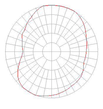 | ||||||||||||||||||
| Azimuth | Ratio | Azimuth | Ratio | Azimuth | Ratio | Azimuth | Ratio | ||||||||||||
| 0 | 1.000 | 10 | 1.000 | 20 | 1.000 | 30 | 1.000 | ||||||||||||
| 40 | 0.960 | 50 | 0.910 | 60 | 0.850 | 70 | 0.800 | ||||||||||||
| 80 | 0.770 | 90 | 0.750 | 100 | 0.740 | 110 | 0.740 | ||||||||||||
| 120 | 0.790 | 130 | 0.830 | 140 | 0.850 | 150 | 0.860 | ||||||||||||
| 160 | 0.890 | 170 | 0.920 | 180 | 0.945 | 190 | 0.970 | ||||||||||||
| 200 | 1.000 | 210 | 0.990 | 220 | 0.980 | 230 | 0.930 | ||||||||||||
| 240 | 0.840 | 250 | 0.740 | 260 | 0.660 | 266 | 0.630 | ||||||||||||
| 270 | 0.620 | 280 | 0.640 | 290 | 0.670 | 300 | 0.730 | ||||||||||||
| 307 | 0.740 | 310 | 0.750 | 320 | 0.810 | 330 | 0.860 | ||||||||||||
| 332 | 0.880 | 340 | 0.940 | 350 | 1.000 | ||||||||||||||
Structure Registration Number 1042954 Structure Type: LTOWER Registered To: American Towers LLC Structure Address: 1701 Absecon Blvd (010111) Atlantic City, NJ County Name: Atlantic County ASR Issued: 11/21/2019 Date Built: 11/18/2003 Site Elevation: 2.7 m (9 ft.) Structure Height: 109.7 m (360 ft.) Height Overall: 110.3 m (362 ft.) Overall Height AMSL: 113 m (371 ft.) FAA Determination: 11/01/2019 FAA Study #: 2019-AEA-12571-OE FAA Circular #: 70/7460-1L Paint & Light FAA Chapters: 4, 8, 12 PRIOR STUDY 2015-AEA-5007-OE 39-22-52.0 N 74-27-00.6 W (NAD 83) 39-22-51.6 N 74-27-02.1 W (Converted to NAD 27) |
7136 S. Yale Ave. Suite 501 Tulsa, OK 74136 Phone: 918-664-4581 Limited Liability Company | Date: 11/08/2001 Application Certifier EQUITY COMMUNICATIONS, L.P. 8025 Black Horse Pike, Suite 100 W. Atlantic City, NJ 08232 Applicant MICHAELFERRIOLA 8025 Black Horse Pike, Suite 100 W. Atlantic City, NJ 08232 ARTHUR S. LANDERHOLM, ESQ. Latham & Watkins | |||||||||||||||||
|
| ||||||||||||||||||