
FCCInfo.com
A Service of Cavell, Mertz & Associates, Inc.
(855) FCC-INFO
|
|
|
|  |
|
|||||||||||||||
|
|
WEGN Channel: 204A 88.7 MHz Kankakee, Illinois Service: FM - A full-service FM station or application. Facility ID: 171523 Fac. Service: FM Status: License Application Accepted: 10/03/2011 Application Granted: 10/11/2011 File Number: BMLED-20111003AEK License Expires: 00/00/0000 Prefix Type: This is a modification of license for a noncommercial educational FM station Application Type: Minor Modification FCC Website Links: LMS Facility Details This Application CDBS Application Other WEGN Applications Other WEGN Applications in CDBS Including Superseded Applications Mailing Address Correspondence for WEGN Correspondence related to application BMLED-20111003AEK Service Contour - Open Street Map or USGS Map (60 dBu) Service Contour - KML / Google Earth (60 dBu) Public Inspection Files Facility Type: NON-COMMERCIAL EDUC. FM Class: A, A Zone I; I-A; or II station; with 0.1kW-6kW ERP and a class contour distance <=28km Site Location: 41-12-26.6 N 87-58-21.8 W (NAD 83) Site Location: 41-12-26.5 N 87-58-21.6 W (Converted to NAD 27) Effective Radiated Power: 5 kW Transmitter Output Power: 3.371 kW Antenna Center HAAT: 65 m (213 ft.) Antenna Center AMSL: 256.1 m (840 ft.) Antenna Center HAG: 65 m (213 ft.) Calculated Site Elevation: 191.1 m. (627 ft.) Height Overall*: 79.2 m (260 ft.) (* As Filed In This Application, may differ from ASR Data, Below.) Directional Antenna Antenna Make/Model: ALP 08.02.712 Antenna ID: 101478 Polarization:
| ||||||||||||||||||
| Antenna Data for Antenna Id: 101478 WEGN FM File: BMLED-20111003AEK ALP - 08.02.712 Service: FM | 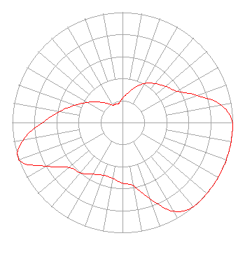 | ||||||||||||||||||
| Azimuth | Ratio | Azimuth | Ratio | Azimuth | Ratio | Azimuth | Ratio | ||||||||||||
| 0 | 0.220 | 10 | 0.270 | 20 | 0.340 | 30 | 0.410 | ||||||||||||
| 40 | 0.460 | 50 | 0.510 | 60 | 0.570 | 70 | 0.720 | ||||||||||||
| 80 | 0.910 | 90 | 1.000 | 100 | 1.000 | 110 | 1.000 | ||||||||||||
| 120 | 1.000 | 130 | 1.000 | 140 | 1.000 | 150 | 0.930 | ||||||||||||
| 160 | 0.740 | 170 | 0.585 | 180 | 0.551 | 190 | 0.514 | ||||||||||||
| 200 | 0.509 | 210 | 0.541 | 220 | 0.596 | 230 | 0.634 | ||||||||||||
| 240 | 0.793 | 250 | 1.000 | 260 | 0.915 | 270 | 0.727 | ||||||||||||
| 280 | 0.577 | 290 | 0.458 | 300 | 0.364 | 310 | 0.289 | ||||||||||||
| 320 | 0.230 | 330 | 0.183 | 340 | 0.178 | 350 | 0.178 | ||||||||||||
Structure Registration Number 1246076 Structure Type: TOWER Registered To: SBA 2012 TC Assets, LLC Structure Address: 6063 N. 500w Rd Bourbonnais, IL County Name: Kankakee County ASR Issued: 01/09/2013 Date Built: 04/04/2005 Site Elevation: 191.1 m (627 ft.) Structure Height: 76.2 m (250 ft.) Height Overall: 79.2 m (260 ft.) Overall Height AMSL: 270.3 m (887 ft.) FAA Determination: 11/04/2004 FAA Study #: 2004-AGL-6418-OE FAA Circular #: 70/7460-1K Paint & Light FAA Chapters: 4, 8, 12 Removed expiration date from determination. Scenario 1./jjs/case#635066 41-12-26.6 N 87-58-21.8 W (NAD 83) 41-12-26.5 N 87-58-21.6 W (Converted to NAD 27) |
One University Avenue Suite 100 Bourbonnais, IL 60914 Phone: 815-939-5037 Private Not-for-Profit Educational Institution | Date: 10/03/2011 Application Certifier THE POWER FOUNDATION 185 Commerce Center Greenville, SC 29615 Applicant RICHARD A. JESSE Po Box 347 Hartville, MO 65667-0347 CONSULTING ENGINEER JOHN C. TRENT, ESQ. Putbrese Hunsaker & Trent, P.c. | |||||||||||||||||