
FCCInfo.com
A Service of Cavell, Mertz & Associates, Inc.
(855) FCC-INFO
|
|
|
|
|
||||||||||||||||
|
|
WMGM Channel: 279B 103.7 MHz Atlantic City, New Jersey Service: FM - A full-service FM station or application. Facility ID: 61100 Fac. Service: FM Status: License Application Accepted: 11/21/1997 Application Granted: 03/31/1998 File Number: BLH-19971121KA License Expires: 00/00/0000 Prefix Type: This is a license for a commercial FM station Application Type: License To Cover FCC Website Links: LMS Facility Details This Application CDBS Application Other WMGM Applications Other WMGM Applications in CDBS Including Superseded Applications Mailing Address Correspondence for WMGM Correspondence related to application BLH-19971121KA Service Contour - Open Street Map or USGS Map (54 dBu) Service Contour - KML / Google Earth (54 dBu) Public Inspection Files History Cards for WMGM Facility Type: FM STATION Class: B, A Zone I or I-A station; with 25kW-50kW ERP and a class contour distance 39km-52km Site Location: 39-23-24.4 N 74-30-43.5 W (NAD 83) Site Location: 39-23-24.0 N 74-30-45.0 W (Converted to NAD 27) Effective Radiated Power: 50 kW Antenna Center HAAT: 106 m (348 ft.) Antenna Center AMSL: 112 m (367 ft.) Antenna Center HAG: 111 m (364 ft.) Calculated Site Elevation: 1 m. (3 ft.) Height Overall*: 119 m (390 ft.) (* As Filed In This Application, may differ from ASR Data, Below.) Directional Antenna Antenna Make/Model: Oddball; usually designed by Applicant ODD970221IA Antenna ID: 15164 Polarization: | ||||||||||||||||||
| Antenna Data for Antenna Id: 15164 WMGM FM File: BLH-19971121KA Oddball; usually designed by Applicant - ODD970221IA Service: FM | 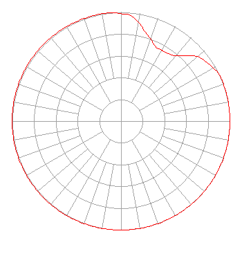 | ||||||||||||||||||
| Azimuth | Ratio | Azimuth | Ratio | Azimuth | Ratio | Azimuth | Ratio | ||||||||||||
| 0 | 0.985 | 5 | 0.975 | 10 | 0.920 | 15 | 0.850 | ||||||||||||
| 20 | 0.800 | 25 | 0.752 | 30 | 0.750 | 35 | 0.755 | ||||||||||||
| 40 | 0.782 | 45 | 0.852 | 50 | 0.920 | 55 | 0.951 | ||||||||||||
| 60 | 0.977 | 65 | 1.000 | 70 | 1.000 | 80 | 1.000 | ||||||||||||
| 90 | 1.000 | 100 | 1.000 | 110 | 1.000 | 120 | 1.000 | ||||||||||||
| 130 | 1.000 | 140 | 1.000 | 150 | 1.000 | 160 | 1.000 | ||||||||||||
| 170 | 1.000 | 180 | 1.000 | 190 | 1.000 | 200 | 1.000 | ||||||||||||
| 210 | 1.000 | 220 | 1.000 | 230 | 1.000 | 240 | 1.000 | ||||||||||||
| 250 | 1.000 | 260 | 1.000 | 270 | 1.000 | 280 | 1.000 | ||||||||||||
| 290 | 1.000 | 300 | 1.000 | 310 | 1.000 | 320 | 1.000 | ||||||||||||
| 330 | 1.000 | 340 | 1.000 | 350 | 1.000 | 355 | 1.000 | ||||||||||||
Structure Registration Number 1041208 Structure Type: TOWER Registered To: LONGPORT MEDIA, LLC Structure Address: Old Tpke S Of Sewage Treatment Plt Pleasantville, NJ County Name: Atlantic County ASR Issued: 10/11/2011 Date Built: 12/01/1987 Site Elevation: 1.5 m (5 ft.) Structure Height: 118 m (387 ft.) Height Overall: 118.9 m (390 ft.) Overall Height AMSL: 120.4 m (395 ft.) FAA Determination: 07/14/1997 FAA Study #: 97-AEA-0124-OE FAA Circular #: 70/7460-1J Paint & Light FAA Chapters: 3, 4, 5, 13 39-23-24.0 N 74-30-44.0 W (NAD 83) 39-23-23.6 N 74-30-45.5 W (Converted to NAD 27) |
C/o Miller Gallagher & Grimley 26 South Pennsylvania Avenue, Suite 201 Atlantic City, NJ 08401 Phone: 609-345-4441 | Date: 11/21/1997 Application Certifier SOUTH JERSEY RADIO, INC. South Jersey Radio, Inc. 1601 New Road Linwood, NJ 08221 Applicant | |||||||||||||||||