
FCCInfo.com
A Service of Cavell, Mertz & Associates, Inc.
(855) FCC-INFO
|
|
|
|
|
||||||||||||||||
|
|
W261DQ Channel: 261D 100.1 MHz Hazleton, Pennsylvania Service: FX - A translator or application for a translator. Facility ID: 200831 Fac. Service: FX Programming Delivery Method: Unspecified Status: License Application Accepted: 01/15/2019 Application Granted: 05/17/2019 File Number: BLFT-20190115AAL License Expires: 00/00/0000 Prefix Type: This is a license for a translator Application Type: License To Cover FCC Website Links: LMS Facility Details This Application CDBS Application Other W261DQ Applications Other W261DQ Applications in CDBS Including Superseded Applications Mailing Address Correspondence for W261DQ Correspondence related to application BLFT-20190115AAL Service Contour - Open Street Map or USGS Map (60 dBu) Service Contour - KML / Google Earth (60 dBu) Class: D, A Noncommercial educational operating with no more than 10W Site Location: 40-56-24.0 N 75-58-03.0 W (NAD 83) Site Location: 40-56-23.7 N 75-58-04.3 W (Converted to NAD 27) Effective Radiated Power: 0.055 kW Horiz. ; 0 kW Vert. Transmitter Output Power: 0.025 kW Antenna Center HAAT: 189 m Horiz.; 0 m Vert. Antenna Center AMSL: 633 m Horiz.; 0 m Vert. Antenna Center HAG: 109 m Horiz.; 0 m Vert. Site Elevation: 524 m. (1719 ft.) Height Overall*: 125 m (410 ft.) (* As Filed In This Application, may differ from ASR Data, Below.) Directional Antenna Antenna Make/Model: None Antenna ID: 130484 Polarization:
| ||||||||||||||||||
| Antenna Data for Antenna Id: 130484 W261DQ FX File: BLFT-20190115AAL None - Service: FX | 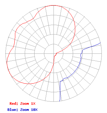 | ||||||||||||||||||
| Azimuth | Ratio | Azimuth | Ratio | Azimuth | Ratio | Azimuth | Ratio | ||||||||||||
| 0 | 1.000 | 10 | 0.981 | 20 | 0.919 | 30 | 0.823 | ||||||||||||
| 40 | 0.699 | 50 | 0.557 | 60 | 0.408 | 70 | 0.214 | ||||||||||||
| 80 | 0.078 | 90 | 0.058 | 100 | 0.058 | 110 | 0.058 | ||||||||||||
| 120 | 0.058 | 130 | 0.058 | 140 | 0.058 | 150 | 0.058 | ||||||||||||
| 160 | 0.058 | 170 | 0.078 | 180 | 0.214 | 190 | 0.408 | ||||||||||||
| 200 | 0.557 | 210 | 0.699 | 220 | 0.823 | 230 | 0.919 | ||||||||||||
| 240 | 0.981 | 250 | 1.000 | 260 | 0.981 | 270 | 0.919 | ||||||||||||
| 280 | 0.842 | 290 | 0.854 | 300 | 0.906 | 310 | 0.906 | ||||||||||||
| 320 | 0.854 | 330 | 0.842 | 340 | 0.919 | 350 | 0.981 | ||||||||||||
Structure Registration Number 1026597 Structure Type: TOWER Registered To: Panorama PA, Inc. Structure Address: Berner Ave And East Streets Hazleton, PA County Name: Luzerne County ASR Issued: 12/11/2012 Date Built: 01/01/1976 Site Elevation: 524.2 m (1720 ft.) Structure Height: 111 m (364 ft.) Height Overall: 125.3 m (411 ft.) Overall Height AMSL: 649.5 m (2131 ft.) FAA Determination: 10/04/1979 FAA Study #: 79-AEA-993-OE Paint & Light FAA Chapters: 1, 3, 12, 21 40-56-24.0 N 75-58-03.0 W (NAD 83) 40-56-23.7 N 75-58-04.3 W (Converted to NAD 27) |
54 Wilmar Drive P.o. Box 701 Tunkhannock, PA 18657 Phone: 570-836-4200 Limited Liability Company | Date: 01/15/2019 Application Certifier J.M.J. RADIO, INC. Oblates Of St. Joseph 1880 Highway 315 Pittston, PA 18640 Applicant ROBERT D REITE 1100 Schooley Ave Exeter, PA 18643 CONSULTANT STUART W. NOLAN, JR. Legalworks Apostolate, Pllc 4 Family Life Lane Front Royal, VA 22630 | |||||||||||||||||