
FCCInfo.com
A Service of Cavell, Mertz & Associates, Inc.
(855) FCC-INFO
|
|
|
|  |
|
|||||||||||||||
|
|
KNBE Channel: 205C3 88.9 MHz Beatrice, Nebraska Service: FM - A full-service FM station or application. Facility ID: 106561 Fac. Service: FM Status: License Application Accepted: 06/02/2010 Application Granted: 07/15/2010 File Number: BLED-20100602AJP License Expires: 00/00/0000 Prefix Type: This is a license for a noncommercial educational FM station Application Type: License To Cover FCC Website Links: LMS Facility Details This Application CDBS Application Other KNBE Applications Other KNBE Applications in CDBS Including Superseded Applications Mailing Address Correspondence for KNBE Correspondence related to application BLED-20100602AJP Service Contour - Open Street Map or USGS Map (60 dBu) Service Contour - KML / Google Earth (60 dBu) Public Inspection Files Facility Type: NON-COMMERCIAL EDUC. FM Class: C3, A Zone II station; with 6kW-25kW ERP and a class contour distance 28km-39km Site Location: 40-33-03.0 N 96-38-46.1 W (NAD 83) Site Location: 40-33-03.0 N 96-38-45.0 W (Converted to NAD 27) Effective Radiated Power: 0 kW Horiz. ; 7.5 kW Vert. Transmitter Output Power: 1.492 kW Antenna Center HAAT: 0 m Horiz.; 146 m Vert. Antenna Center AMSL: 0 m Horiz.; 564 m Vert. Antenna Center HAG: 0 m Horiz.; 140 m Vert. Calculated Site Elevation: m. Height Overall*: 150.9 m (495 ft.) (* As Filed In This Application, may differ from ASR Data, Below.) Directional Antenna Antenna Make/Model: Shivley 6513-2/2-DA, two sections Antenna ID: 99305 Polarization:
| ||||||||||||||||||
| Antenna Data for Antenna Id: 99305 KNBE FM File: BLED-20100602AJP Shivley - 6513-2/2-DA, two sections Service: FM | 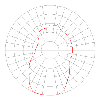 | ||||||||||||||||||
| Azimuth | Ratio | Azimuth | Ratio | Azimuth | Ratio | Azimuth | Ratio | ||||||||||||
| 0 | 0.550 | 10 | 0.558 | 20 | 0.553 | 30 | 0.500 | ||||||||||||
| 40 | 0.500 | 45 | 0.500 | 50 | 0.500 | 60 | 0.500 | ||||||||||||
| 70 | 0.500 | 80 | 0.500 | 90 | 0.500 | 100 | 0.500 | ||||||||||||
| 110 | 0.500 | 120 | 0.500 | 130 | 0.550 | 135 | 0.613 | ||||||||||||
| 140 | 0.675 | 150 | 0.775 | 160 | 0.921 | 170 | 1.000 | ||||||||||||
| 180 | 1.000 | 190 | 1.000 | 200 | 1.000 | 210 | 0.891 | ||||||||||||
| 220 | 0.725 | 225 | 0.664 | 230 | 0.603 | 240 | 0.504 | ||||||||||||
| 250 | 0.412 | 260 | 0.342 | 270 | 0.324 | 280 | 0.311 | ||||||||||||
| 290 | 0.298 | 300 | 0.308 | 310 | 0.343 | 315 | 0.361 | ||||||||||||
| 320 | 0.379 | 330 | 0.471 | 340 | 0.496 | 350 | 0.495 | ||||||||||||
Structure Registration Number 1253057 [ASR Heights Differ from KNBE Application] Structure Type: TOWER Registered To: Family Worship Center Church, Inc. Structure Address: South Of Pella Road; East Of South 54th Street Firth, NE County Name: Lancaster County ASR Issued: 04/16/2010 Date Built: 08/01/2008 Site Elevation: 423.6 m (1390 ft.) Structure Height: 150 m (492 ft.) Height Overall: 150.9 m (495 ft.) Overall Height AMSL: 574.5 m (1885 ft.) FAA Determination: 04/12/2010 FAA Study #: 2010-ACE-443-OE FAA Circular #: 70/7460-1K Paint & Light FAA Chapters: 4, 6, 12 OM&L to remain the same as prior study = 24-HR MED-STROBES 40-33-03.0 N 96-38-46.1 W (NAD 83) 40-33-03.0 N 96-38-45.0 W (Converted to NAD 27) |
P.o. Box 262550 Baton Rouge, LA 70810 Phone: 225-768-3102 Fax: 225-768-3102 | Date: 06/02/2010 Application Certifier FAMILY WORSHIP CENTER CHURCH, INC. P.o. Box 262550 Baton Rouge, LA 70810 Applicant JEFFERSON G. BROCK Graham Brock, Inc. P. O. Box 24466 St. Simons Island, GA 31522-7466 TECHNICAL CONSULTANT JOHN C. TRENT, ESQUIRE Putbrese Hunsaker & Trent, P.c. | |||||||||||||||||