
FCCInfo.com
A Service of Cavell, Mertz & Associates, Inc.
(855) FCC-INFO
|
|
WYRS from 12/17/1993 |
|
|
||||||||||||||||||||||
|
|
WYRS Channel: 214B1 90.7 MHz Manahawkin, New Jersey Service: FM - A full-service FM station or application. Facility ID: 52173 Fac. Service: FM Analog & Digital Status: License Application Accepted: 06/19/2007 Application Granted: 07/09/2007 File Number: BLED-20070619ABP License Expires: 00/00/0000 Prefix Type: This is a license for a noncommercial educational FM station Application Type: License To Cover FCC Website Links: LMS Facility Details This Application CDBS Application Other WYRS Applications Other WYRS Applications in CDBS Including Superseded Applications Mailing Address Correspondence for WYRS Correspondence related to application BLED-20070619ABP Service Contour - Open Street Map or USGS Map (60 dBu) Service Contour - KML / Google Earth (60 dBu) Public Inspection Files Facility Type: NON-COMMERCIAL EDUC. FM Class: B1, A Zone I or I-A station; with 6kW-25kW ERP and a class contour distance 28km-39km Site Location: 39-38-24.4 N 74-17-30.5 W (NAD 83) Site Location: 39-38-24.0 N 74-17-32.0 W (Converted to NAD 27) Effective Radiated Power: 0.001 kW Horiz. ; 15 kW Vert. Transmitter Output Power: 3.157 kW Antenna Center HAAT: 80 m (262 ft.) Antenna Center AMSL: 89 m (292 ft.) Antenna Center HAG: 88 m (289 ft.) Site Elevation: 1 m. (3 ft.) Height Overall*: 92 m (302 ft.) (* As Filed In This Application, may differ from ASR Data, Below.) Directional Antenna Antenna Make/Model: Shivley 6513-3-DA -SPECIAL (SLANT) Antenna ID: 72516 Polarization:
| ||||||||||||||||||||||||
| Antenna Data for Antenna Id: 72516 WYRS FM File: BLED-20070619ABP Shivley - 6513-3-DA -SPECIAL (SLANT) Service: FM | 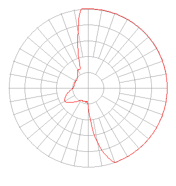 | ||||||||||||||||||||||||
| Azimuth | Ratio | Azimuth | Ratio | Azimuth | Ratio | Azimuth | Ratio | ||||||||||||||||||
| 0 | 1.000 | 10 | 1.000 | 20 | 1.000 | 30 | 1.000 | ||||||||||||||||||
| 40 | 1.000 | 50 | 1.000 | 60 | 1.000 | 70 | 1.000 | ||||||||||||||||||
| 80 | 1.000 | 90 | 1.000 | 100 | 1.000 | 110 | 1.000 | ||||||||||||||||||
| 120 | 1.000 | 130 | 1.000 | 140 | 1.000 | 150 | 1.000 | ||||||||||||||||||
| 160 | 1.000 | 170 | 0.708 | 180 | 0.224 | 190 | 0.178 | ||||||||||||||||||
| 200 | 0.178 | 210 | 0.178 | 220 | 0.224 | 230 | 0.282 | ||||||||||||||||||
| 240 | 0.335 | 250 | 0.299 | 260 | 0.237 | 270 | 0.188 | ||||||||||||||||||
| 280 | 0.178 | 290 | 0.178 | 300 | 0.178 | 310 | 0.178 | ||||||||||||||||||
| 320 | 0.204 | 330 | 0.257 | 340 | 0.299 | 350 | 0.708 | ||||||||||||||||||
| 355 | 1.000 | ||||||||||||||||||||||||
Structure Registration Number 1044762 [ASR Heights Differ from WYRS Application] Structure Type: TOWER Registered To: WYRS Broadcasting Structure Address: End Of Murphy Dr 1/2 Mi Off Us Hwy 9 West Creek, NJ County Name: Ocean County ASR Issued: 11/19/2003 Date Built: 03/15/1984 Site Elevation: 0.9 m (3 ft.) Structure Height: 91.4 m (300 ft.) Height Overall: 91.4 m (300 ft.) Overall Height AMSL: 92.3 m (303 ft.) FAA Determination: 11/04/1983 FAA Study #: 80-AEA-899-OE Paint & Light FAA Chapters: 1, 3, 11, 21 RED LIGHTS/PAINT 39-38-24.0 N 74-17-31.0 W (NAD 83) 39-38-23.6 N 74-17-32.5 W (Converted to NAD 27) |
Manahawkin, NJ 08050 Phone: 609-978-1678 Corporation | Date: 06/19/2007 Application Certifier WYRS BROADCASTING Po Box 730 Manahawkin, NJ 08050 Applicant ROBERT E. WICK Po Box 730 Manahawkin, NJ 08050 STATION ENGINEER BOB WICK Wyrs Broadcasting | |||||||||||||||||||||||
| |||||||||||||||||||||||||