
FCCInfo.com
A Service of Cavell, Mertz & Associates, Inc.
(855) FCC-INFO
|
|
WWIL-FM from 09/23/1992 |
|
|
|||||||||||||||||||
|
|
WWIL-FM Channel: 213C2 90.5 MHz Wilmington, North Carolina Service: FM - A full-service FM station or application. Facility ID: 12165 Fac. Service: FM Status: License Application Accepted: 01/26/2016 Application Granted: 02/03/2016 File Number: BLED-20160126ACQ License Expires: 00/00/0000 Prefix Type: This is a license for a noncommercial educational FM station Application Type: License To Cover FCC Website Links: LMS Facility Details This Application CDBS Application Other WWIL-FM Applications Other WWIL-FM Applications in CDBS Including Superseded Applications Mailing Address Correspondence for WWIL-FM Correspondence related to application BLED-20160126ACQ Service Contour - Open Street Map or USGS Map (60 dBu) Service Contour - KML / Google Earth (60 dBu) Public Inspection Files Facility Type: NON-COMMERCIAL EDUC. FM Class: C2, A Zone II station; with 25kW-50kW ERP and a class contour distance 39km-52km Site Location: 34-14-37.6 N 78-07-23.0 W (NAD 83) Site Location: 34-14-37.0 N 78-07-24.0 W (Converted to NAD 27) Effective Radiated Power: 31 kW Transmitter Output Power: 11.1 kW Antenna Center HAAT: 189 m (620 ft.) Antenna Center AMSL: 198 m (650 ft.) Antenna Center HAG: 183 m (600 ft.) Site Elevation: 15 m. (49 ft.) Height Overall*: 245 m (804 ft.) (* As Filed In This Application, may differ from ASR Data, Below.) Directional Antenna Antenna Make/Model: Propagation System Inc PSIFMR-4C-DA, 4 sections, 1 wavelength spaced Antenna ID: 113626 Polarization: | |||||||||||||||||||||
| Antenna Data for Antenna Id: 113626 WWIL-FM FM File: BLED-20160126ACQ Propagation System Inc - PSIFMR-4C-DA, 4 sections, 1 wavelength spaced Service: FM | 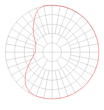 | |||||||||||||||||||||
| Azimuth | Ratio | Azimuth | Ratio | Azimuth | Ratio | Azimuth | Ratio | |||||||||||||||
| 0 | 1.000 | 10 | 1.000 | 20 | 1.000 | 30 | 1.000 | |||||||||||||||
| 40 | 1.000 | 50 | 1.000 | 60 | 1.000 | 70 | 1.000 | |||||||||||||||
| 80 | 1.000 | 90 | 1.000 | 100 | 1.000 | 110 | 1.000 | |||||||||||||||
| 120 | 1.000 | 130 | 1.000 | 140 | 1.000 | 150 | 1.000 | |||||||||||||||
| 160 | 1.000 | 170 | 1.000 | 180 | 1.000 | 190 | 1.000 | |||||||||||||||
| 200 | 1.000 | 210 | 0.968 | 220 | 0.883 | 230 | 0.735 | |||||||||||||||
| 240 | 0.585 | 250 | 0.467 | 260 | 0.399 | 270 | 0.358 | |||||||||||||||
| 280 | 0.356 | 290 | 0.368 | 300 | 0.405 | 310 | 0.500 | |||||||||||||||
| 320 | 0.625 | 330 | 0.768 | 340 | 0.925 | 350 | 1.000 | |||||||||||||||
Structure Registration Number 1024421 Structure Type: TOWER Registered To: Sunrise Broadcasting, LLC Structure Address: 487 Meters From Int Of Malmo/collon Mintz Rd Brunswick County Riegelwood, NC County Name: Brunswick County ASR Issued: 07/09/2013 Date Built: 07/27/1998 Site Elevation: 15.2 m (50 ft.) Structure Height: 243.8 m (800 ft.) Height Overall: 244.7 m (803 ft.) Overall Height AMSL: 259.9 m (853 ft.) FAA Determination: 06/11/1997 FAA Study #: 97-ASO-0871-OE FAA Circular #: 70/7460-1J Paint & Light FAA Chapters: 3, 4, 5, 13 34-14-38.0 N 78-07-23.0 W (NAD 83) 34-14-37.4 N 78-07-24.0 W (Converted to NAD 27) |
P.o. Box 957 Wilmington, NC 28402 Phone: 910-763-2452 Not-for-Profit | Date: 01/26/2016 Application Certifier CAROLINA CHRISTIAN RADIO, INC. P.o.box 957 Wilmington, NC 28402-0957 Applicant JIM STEPHENS Po Box 957 Wilmington, NC 28402 PRESIDENT JAMES J STEPHENS JR Carolina Christian Radio, Inc | ||||||||||||||||||||
| ||||||||||||||||||||||