
FCCInfo.com
A Service of Cavell, Mertz & Associates, Inc.
(855) FCC-INFO
|
|
|
|  |
|
|||||||||||||||
|
|
KBDO Channel: 219C1 91.7 MHz Des Arc, Arkansas Service: FM - A full-service FM station or application. Facility ID: 78630 Fac. Service: FM Status: License 73.215 Station Application Accepted: 09/30/1999 Application Granted: 11/19/1999 File Number: BLED-19990910AAI License Expires: 00/00/0000 Prefix Type: This is a license for a noncommercial educational FM station Application Type: License To Cover FCC Website Links: LMS Facility Details This Application CDBS Application Other KBDO Applications Other KBDO Applications in CDBS Including Superseded Applications Mailing Address Correspondence for KBDO Correspondence related to application BLED-19990910AAI Service Contour - Open Street Map or USGS Map (60 dBu) Service Contour - KML / Google Earth (60 dBu) Public Inspection Files Facility Type: FM STATION Class: C1, A Zone II station; with 50kW-100kW ERP and a class contour distance 52km-72km Site Location: 35-00-08.3 N 91-44-41.5 W (NAD 83) Site Location: 35-00-08.0 N 91-44-41.0 W (Converted to NAD 27) Effective Radiated Power: 0 kW Horiz. ; 56 kW Vert. Transmitter Output Power: 7.6 kW Antenna Center HAAT: 0 m Horiz.; 208 m Vert. Antenna Center AMSL: 0 m Horiz.; 272 m Vert. Antenna Center HAG: 0 m Horiz.; 198 m Vert. Calculated Site Elevation: m. Height Overall*: 210 m (689 ft.) (* As Filed In This Application, may differ from ASR Data, Below.) Directional Antenna Antenna Make/Model: Shivley 6510-1055DA Antenna ID: 14892 Polarization: | ||||||||||||||||||
| Antenna Data for Antenna Id: 14892 KBDO FM File: BLED-19990910AAI Shivley - 6510-1055DA Service: FM | 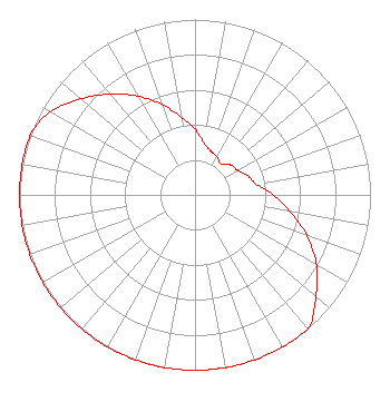 | ||||||||||||||||||
| Azimuth | Ratio | Azimuth | Ratio | Azimuth | Ratio | Azimuth | Ratio | ||||||||||||
| 0 | 0.375 | 10 | 0.300 | 20 | 0.265 | 30 | 0.250 | ||||||||||||
| 40 | 0.230 | 50 | 0.265 | 60 | 0.280 | 70 | 0.320 | ||||||||||||
| 80 | 0.354 | 90 | 0.446 | 100 | 0.549 | 110 | 0.680 | ||||||||||||
| 120 | 0.800 | 130 | 0.900 | 140 | 1.000 | 150 | 1.000 | ||||||||||||
| 160 | 1.000 | 170 | 1.000 | 180 | 1.000 | 190 | 1.000 | ||||||||||||
| 200 | 1.000 | 210 | 1.000 | 220 | 1.000 | 230 | 1.000 | ||||||||||||
| 240 | 1.000 | 250 | 1.000 | 260 | 1.000 | 270 | 1.000 | ||||||||||||
| 280 | 1.000 | 290 | 1.000 | 300 | 0.949 | 310 | 0.850 | ||||||||||||
| 320 | 0.749 | 330 | 0.650 | 340 | 0.549 | 350 | 0.450 | ||||||||||||
Structure Registration Number 1058475 [ASR Heights Differ from KBDO Application] Structure Type: TOWER Registered To: AMERICAN FAMILY ASSOCIATION Structure Address: 1/4 Mi N Of The Int Of Hwy 13 & 38 Hickory Plains, AR County Name: Prairie County ASR Issued: 10/19/2009 Date Built: 08/02/1999 Site Elevation: 74 m (243 ft.) Structure Height: 210 m (689 ft.) Height Overall: 210 m (689 ft.) Overall Height AMSL: 284 m (932 ft.) FAA Determination: 11/30/1998 FAA Study #: 98-ASW-1158-OE FAA Circular #: 70/7460-1J Paint & Light FAA Chapters: 4, 6, 13 Removed expiration and final dates from determination. Scenario 2./jjs/case#635066 35-00-08.0 N 91-44-41.0 W (NAD 83) 35-00-07.7 N 91-44-40.5 W (Converted to NAD 27) |
Po Box 2440 Tupelo, MS 38801-2440 Phone: 662-844-8888 Not-for-Profit | Date: 09/10/1999 Application Certifier AMERICAN FAMILY ASSOCIATION Po Drawer 2440 Tupelo, MS 38803 Applicant TECHNICAL CONSULTANT | |||||||||||||||||