
FCCInfo.com
A Service of Cavell, Mertz & Associates, Inc.
(855) FCC-INFO
|
|
WWDV from 02/21/2001 WWDV from 07/22/1983 WWDV from 02/29/1980 WWDV from 08/01/1979 |
|  |
|
|||||||||||||||
|
|
WWDV Channel: 245B 96.9 MHz Zion, Illinois Service: FM - A full-service FM station or application. Facility ID: 49547 Fac. Service: FM Analog & Digital Status: License Application Accepted: 11/21/2013 Application Granted: 12/05/2013 File Number: BMLH-20131121AIN License Expires: 00/00/0000 Prefix Type: This is a modification of a license for a commecial FM station Application Type: Minor Modification FCC Website Links: LMS Facility Details This Application CDBS Application Other WWDV Applications Other WWDV Applications in CDBS Including Superseded Applications Mailing Address Correspondence for WWDV Correspondence related to application BMLH-20131121AIN Service Contour - Open Street Map or USGS Map (54 dBu) Service Contour - KML / Google Earth (54 dBu) Public Inspection Files History Cards for WWDV Facility Type: FM STATION Class: B, A Zone I or I-A station; with 25kW-50kW ERP and a class contour distance 39km-52km Site Location: 42-30-35.1 N 87-53-11.3 W (NAD 83) Site Location: 42-30-35.0 N 87-53-11.0 W (Converted to NAD 27) Effective Radiated Power: 50 kW Horiz. ; 38 kW Vert. Transmitter Output Power: 19.5 kW Antenna Center HAAT: 148 m (486 ft.) Antenna Center AMSL: 360 m (1181 ft.) Antenna Center HAG: 137 m (449 ft.) Calculated Site Elevation: 223 m. (732 ft.) Height Overall*: 141 m (463 ft.) (* As Filed In This Application, may differ from ASR Data, Below.) Directional Antenna Antenna Make/Model: Cetec JSCP-3D Antenna ID: 13676 Polarization: | ||||||||||||||||||
| Antenna Data for Antenna Id: 13676 WWDV FM File: BMLH-20131121AIN Cetec - JSCP-3D Service: FM | 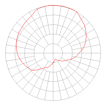 | ||||||||||||||||||
| Azimuth | Ratio | Azimuth | Ratio | Azimuth | Ratio | Azimuth | Ratio | ||||||||||||
| 0 | 1.000 | 10 | 1.000 | 20 | 1.000 | 26 | 1.000 | ||||||||||||
| 30 | 0.990 | 40 | 0.920 | 50 | 0.870 | 60 | 0.800 | ||||||||||||
| 70 | 0.730 | 80 | 0.650 | 90 | 0.550 | 100 | 0.480 | ||||||||||||
| 110 | 0.390 | 120 | 0.310 | 130 | 0.260 | 140 | 0.210 | ||||||||||||
| 150 | 0.170 | 160 | 0.140 | 170 | 0.170 | 180 | 0.210 | ||||||||||||
| 190 | 0.260 | 200 | 0.320 | 210 | 0.360 | 220 | 0.450 | ||||||||||||
| 230 | 0.560 | 240 | 0.610 | 250 | 0.660 | 260 | 0.710 | ||||||||||||
| 270 | 0.750 | 280 | 0.780 | 290 | 0.810 | 300 | 0.830 | ||||||||||||
| 310 | 0.840 | 320 | 0.870 | 330 | 0.900 | 340 | 0.970 | ||||||||||||
| 350 | 0.990 | 357 | 1.000 | ||||||||||||||||
Structure Registration Number 1210425 [ASR Heights Differ from WWDV Application] Structure Type: GTOWER Registered To: Hubbard Radio Chicago, LLC Structure Address: 11513 South Green Bay Road Pleasant Prairie, WI County Name: Kenosha County ASR Issued: 02/24/2023 Date Built: 12/22/1999 Site Elevation: 223.4 m (733 ft.) Structure Height: 140.2 m (460 ft.) Height Overall: 142 m (466 ft.) Overall Height AMSL: 365.4 m (1199 ft.) FAA Determination: 11/06/2013 FAA Study #: 2013-AGL-7582-OE FAA Circular #: 70/7460-1J Paint & Light FAA Chapters: 3, 4, 5, 13 PRIOR STUDY 1999-AGL-5880-OE 42-30-34.9 N 87-53-11.0 W (NAD 83) 42-30-34.8 N 87-53-10.7 W (Converted to NAD 27) |
3415 University Avenue, West St. Paul, MN 55114 Phone: 651-642-4336 Limited Liability Company | Date: 11/21/2013 Application Certifier CHICAGO FCC LICENSE SUB, LLC 3415 University Avenue, West St. Paul, MN 55114-2099 Applicant DAVID C. GARNER Wtop Radio 3400 Idaho Ave Nw Washington, DC 20016-3046 DIRECTOR OF ENGINEERING, HUBBARD RADIO KENNETH E. SATTEN Wilkinson Barker Knauer, Llp | |||||||||||||||||