
FCCInfo.com
A Service of Cavell, Mertz & Associates, Inc.
(855) FCC-INFO
|
|
|
|
|
||||||||||||||||
|
|
K227BB Channel: 227D 93.3 MHz Worland, Wyoming Service: FX - A translator or application for a translator. Facility ID: 139565 Fac. Service: FX Programming Delivery Method: Unspecified Status: License Application Accepted: 03/30/2005 Application Granted: 10/03/2005 File Number: BLFT-20050330AEN License Expires: 00/00/0000 Prefix Type: This is a license for a translator Application Type: License To Cover FCC Website Links: LMS Facility Details This Application CDBS Application Other K227BB Applications Other K227BB Applications in CDBS Including Superseded Applications Mailing Address Correspondence for K227BB Correspondence related to application BLFT-20050330AEN Service Contour - Open Street Map or USGS Map (60 dBu) Service Contour - KML / Google Earth (60 dBu) Class: D, A Noncommercial educational operating with no more than 10W Site Location: 44-03-59.9 N 107-51-52.3 W (NAD 83) Site Location: 44-04-00.1 N 107-51-50.0 W (Converted to NAD 27) Effective Radiated Power: 0.075 kW Transmitter Output Power: 0.1 kW Antenna Center HAAT: 127.8 m Horiz.; 0 m Vert. Antenna Center AMSL: 1440 m (4724 ft.) Antenna Center HAG: 17 m (56 ft.) Site Elevation: 1423 m. (4669 ft.) Height Overall*: 37 m (121 ft.) (* As Filed In This Application, may differ from ASR Data, Below.) Directional Antenna Antenna Make/Model: None Antenna ID: 61047 Polarization:
| ||||||||||||||||||
| Antenna Data for Antenna Id: 61047 K227BB FX File: BLFT-20050330AEN None - Service: FX Pattern and Field Values Include a 230° Clockwise Rotation | 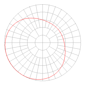 | ||||||||||||||||||
| Azimuth | Ratio | Azimuth | Ratio | Azimuth | Ratio | Azimuth | Ratio | ||||||||||||
| 0 | 0.592 | 10 | 0.566 | 20 | 0.549 | 30 | 0.540 | ||||||||||||
| 40 | 0.535 | 50 | 0.534 | 60 | 0.535 | 70 | 0.540 | ||||||||||||
| 80 | 0.549 | 90 | 0.566 | 100 | 0.592 | 110 | 0.630 | ||||||||||||
| 120 | 0.679 | 130 | 0.735 | 140 | 0.792 | 150 | 0.845 | ||||||||||||
| 160 | 0.892 | 170 | 0.929 | 180 | 0.956 | 190 | 0.975 | ||||||||||||
| 200 | 0.987 | 210 | 0.995 | 220 | 0.999 | 230 | 1.000 | ||||||||||||
| 240 | 0.999 | 250 | 0.995 | 260 | 0.987 | 270 | 0.975 | ||||||||||||
| 280 | 0.956 | 290 | 0.929 | 300 | 0.892 | 310 | 0.845 | ||||||||||||
| 320 | 0.792 | 330 | 0.735 | 340 | 0.679 | 350 | 0.630 | ||||||||||||
Structure Registration Number 1009211 Structure Type: LTOWER Registered To: CommNet Cellular Inc. Structure Address: 2.9 Mi N Us Rt 16 Approx. 3.1 Mi Nw Toman Sand Creek Res. Worland, WY County Name: Washakie County ASR Issued: 01/11/2021 Date Built: 03/31/1994 Site Elevation: 1423.4 m (4670 ft.) Structure Height: 30.5 m (100 ft.) Height Overall: 36.9 m (121 ft.) Overall Height AMSL: 1460.3 m (4791 ft.) FAA Determination: 12/31/2020 FAA Study #: 2020-ANM-6143-OE Paint & Light FAA Chapters: NONE PRIOR STUDY 1994-ANM-83-OE 44-03-58.5 N 107-51-52.0 W (NAD 83) 44-03-58.7 N 107-51-49.7 W (Converted to NAD 27) |
Po Box 3984 Laramie, WY 82071 Phone: 307-766-2439 | Date: 03/30/2005 Application Certifier UNIVERSITY OF WYOMING Po Box 3984 Laramie, WY 82071-3984 Applicant KATE MICHLER Doug Vernier Telecommunications Consulta 721 W. 1st Street, Suite A Cedar Falls, IA 50613 TECHNICAL CONSULTANT MARGARET L. MILLER Dow, Lohnes & Albertson 1200 New Hampshire Ave, Nw Suite 800 Washington, DC 20036 | |||||||||||||||||