
FCCInfo.com
A Service of Cavell, Mertz & Associates, Inc.
(855) FCC-INFO
|
|
|
|
|
||||||||||||||||
|
|
W245CE Channel: 245D 96.9 MHz Morris, Illinois Service: FX - A translator or application for a translator. Facility ID: 158459 Fac. Service: FX Programming Delivery Method: Unspecified Status: License Application Accepted: 06/30/2016 Application Granted: 07/11/2016 File Number: BLFT-20160630AAJ License Expires: 00/00/0000 Prefix Type: This is a license for a translator Application Type: License To Cover FCC Website Links: LMS Facility Details This Application CDBS Application Other W245CE Applications Other W245CE Applications in CDBS Including Superseded Applications Mailing Address Correspondence for W245CE Correspondence related to application BLFT-20160630AAJ Service Contour - Open Street Map or USGS Map (60 dBu) Service Contour - KML / Google Earth (60 dBu) Class: D, A Noncommercial educational operating with no more than 10W Site Location: 41-17-35.1 N 88-20-04.2 W (NAD 83) Site Location: 41-17-35.0 N 88-20-04.0 W (Converted to NAD 27) Effective Radiated Power: 0.25 kW Transmitter Output Power: 0.895 kW Antenna Center HAAT: 0 m Antenna Center AMSL: 244 m (801 ft.) Antenna Center HAG: 76 m (249 ft.) Site Elevation: 168 m. (551 ft.) Height Overall*: 102 m (335 ft.) (* As Filed In This Application, may differ from ASR Data, Below.) Directional Antenna Antenna Make/Model: None Antenna ID: 119459 Polarization:
| ||||||||||||||||||
| Antenna Data for Antenna Id: 119459 W245CE FX File: BLFT-20160630AAJ None - Service: FX | 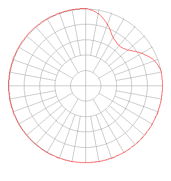 | ||||||||||||||||||
| Azimuth | Ratio | Azimuth | Ratio | Azimuth | Ratio | Azimuth | Ratio | ||||||||||||
| 0 | 1.000 | 10 | 0.950 | 20 | 0.840 | 30 | 0.720 | ||||||||||||
| 40 | 0.680 | 50 | 0.720 | 60 | 0.840 | 70 | 0.950 | ||||||||||||
| 80 | 1.000 | 90 | 1.000 | 100 | 1.000 | 110 | 1.000 | ||||||||||||
| 120 | 1.000 | 130 | 1.000 | 140 | 1.000 | 150 | 1.000 | ||||||||||||
| 160 | 1.000 | 170 | 1.000 | 180 | 1.000 | 190 | 1.000 | ||||||||||||
| 200 | 1.000 | 210 | 1.000 | 220 | 1.000 | 230 | 1.000 | ||||||||||||
| 240 | 1.000 | 250 | 1.000 | 260 | 1.000 | 270 | 1.000 | ||||||||||||
| 280 | 1.000 | 290 | 1.000 | 300 | 1.000 | 310 | 1.000 | ||||||||||||
| 320 | 1.000 | 330 | 1.000 | 340 | 1.000 | 350 | 1.000 | ||||||||||||
Structure Registration Number 1009089 Structure Type: TOWER Registered To: Grundy County Broadcasters, Inc., Structure Address: 1 Mi E Of Gorman Rd On Mc Cardle Rd Coal City, IL County Name: Grundy County ASR Issued: 11/06/2003 Date Built: 01/01/1991 Site Elevation: 168 m (551 ft.) Structure Height: 101 m (331 ft.) Height Overall: 101.8 m (334 ft.) Overall Height AMSL: 269.8 m (885 ft.) FAA Determination: 03/27/1991 FAA Study #: 91-AGL-0485-OE FAA Circular #: 70/7460-1G Paint & Light FAA Chapters: 3, 4, 5, 9 41-17-35.0 N 88-20-04.0 W (NAD 83) 41-17-34.9 N 88-20-03.8 W (Converted to NAD 27) |
One Broadcast Center Plano, IL 60545 Phone: 000-000-0000 | Date: 06/30/2016 Application Certifier WSPY--TV, INC. One Broadcast Center Plano, IL 60545 Applicant LARRY NELSON 1 Broadcast Center Plano, IL 60545 PRESIDENT JOHN NEELY, ESQ. Miller And Neely, P.c. Suite 203 3750 University Blvd., West Kensington, MD 20895 | |||||||||||||||||