
FCCInfo.com
A Service of Cavell, Mertz & Associates, Inc.
(855) FCC-INFO
|
|
|
|
|
||||||||||||||||
|
|
KFLV Channel: 210C3 89.9 MHz Wilber, Nebraska Service: FM - A full-service FM station or application. Facility ID: 89576 Fac. Service: FM Status: License Application Accepted: 05/02/2007 Application Granted: 05/09/2007 File Number: BLED-20070502AFJ License Expires: 00/00/0000 Prefix Type: This is a license for a noncommercial educational FM station Application Type: License To Cover FCC Website Links: LMS Facility Details This Application CDBS Application Other KFLV Applications Other KFLV Applications in CDBS Including Superseded Applications Mailing Address Correspondence for KFLV Correspondence related to application BLED-20070502AFJ Service Contour - Open Street Map or USGS Map (60 dBu) Service Contour - KML / Google Earth (60 dBu) Public Inspection Files Facility Type: NON-COMMERCIAL EDUC. FM Class: C3, A Zone II station; with 6kW-25kW ERP and a class contour distance 28km-39km Site Location: 40-31-06.0 N 96-46-07.1 W (NAD 83) Site Location: 40-31-06.0 N 96-46-06.0 W (Converted to NAD 27) Effective Radiated Power: 5.8 kW Transmitter Output Power: 4.874 kW Antenna Center HAAT: 157 m (515 ft.) Antenna Center AMSL: 585 m (1919 ft.) Antenna Center HAG: 134 m (440 ft.) Site Elevation: 451 m. (1480 ft.) Height Overall*: 234 m (768 ft.) (* As Filed In This Application, may differ from ASR Data, Below.) Directional Antenna Antenna Make/Model: Electronics Research Inc. LP-2E-DA Antenna ID: 76563 Polarization:
| ||||||||||||||||||
| Antenna Data for Antenna Id: 76563 KFLV FM File: BLED-20070502AFJ Electronics Research Inc. - LP-2E-DA Service: FM | 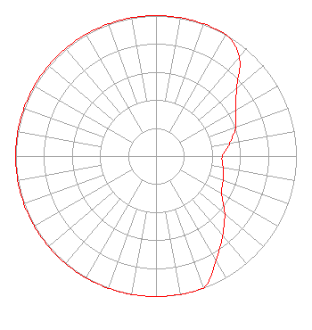 | ||||||||||||||||||
| Azimuth | Ratio | Azimuth | Ratio | Azimuth | Ratio | Azimuth | Ratio | ||||||||||||
| 0 | 1.000 | 10 | 1.000 | 20 | 1.000 | 30 | 1.000 | ||||||||||||
| 40 | 0.922 | 50 | 0.751 | 60 | 0.654 | 70 | 0.605 | ||||||||||||
| 80 | 0.534 | 90 | 0.473 | 100 | 0.484 | 110 | 0.508 | ||||||||||||
| 120 | 0.539 | 130 | 0.639 | 140 | 0.738 | 150 | 0.854 | ||||||||||||
| 160 | 1.000 | 170 | 1.000 | 180 | 1.000 | 190 | 1.000 | ||||||||||||
| 200 | 1.000 | 210 | 1.000 | 220 | 1.000 | 230 | 1.000 | ||||||||||||
| 240 | 1.000 | 250 | 1.000 | 260 | 1.000 | 270 | 1.000 | ||||||||||||
| 280 | 1.000 | 290 | 1.000 | 300 | 1.000 | 310 | 1.000 | ||||||||||||
| 320 | 1.000 | 330 | 1.000 | 340 | 1.000 | 350 | 1.000 | ||||||||||||
Structure Registration Number 1026482 [ASR Heights Differ from KFLV Application] Structure Type: GTOWER Registered To: Vertical Bridge S3 Assets, LLC Structure Address: 1.2 Mi Se / Us-ne-5032 Hallam, NE County Name: Gage County ASR Issued: 01/14/2021 Date Built: 04/01/1988 Site Elevation: 452.3 m (1484 ft.) Structure Height: 234.3 m (769 ft.) Height Overall: 235.6 m (773 ft.) Overall Height AMSL: 687.9 m (2257 ft.) FAA Determination: 10/27/2020 FAA Study #: 2020-ACE-5640-OE FAA Circular #: 70/7460-1J Paint & Light FAA Chapters: 3, 4, 5, 13 PRIOR STUDY 1997-ACE-653-OE 40-31-05.6 N 96-46-06.4 W (NAD 83) 40-31-05.6 N 96-46-05.3 W (Converted to NAD 27) |
5700 West Oaks Blvd Rocklin, CA 95765 Phone: 916-251-1600 Not-for-Profit | Date: 05/02/2007 Application Certifier EDUCATIONAL MEDIA FOUNDATION 5700 West Oaks Blvd Rocklin, CA 95765 Applicant SAM WALLINGTON 5700 West Oaks Blvd Rocklin, CA 95765 DIRECTOR OF ENGINEERING DAVID D. OXENFORD, ESQ Davis Wright Tremaine Llp | |||||||||||||||||