
FCCInfo.com
A Service of Cavell, Mertz & Associates, Inc.
(855) FCC-INFO
|
|
WJKI-FM from 12/17/2004 WJKI-FM from 08/16/2000 WJKI-FM from 11/21/1997 WJKI-FM from 09/08/1995 WJKI-FM from 07/07/1995 WJKI-FM from 03/12/1993 |
|
|
||||||||||||||||
|
|
WJKI-FM Channel: 278A 103.5 MHz Bethany Beach, Delaware Service: FS - A full service FM station auxiliary transmitting antenna or application. Facility ID: 30858 Fac. Service: FM Status: License Application Accepted: 10/15/2015 Application Granted: 10/20/2015 File Number: BXLH-20151015ACD License Expires: 00/00/0000 Prefix Type: This is BXLH Application Type: License To Cover FCC Website Links: LMS Facility Details This Application CDBS Application Other WJKI-FM Applications Other WJKI-FM Applications in CDBS Including Superseded Applications Mailing Address Correspondence for WJKI-FM Correspondence related to application BXLH-20151015ACD Service Contour - Open Street Map or USGS Map (60 dBu) Service Contour - KML / Google Earth (60 dBu) Public Inspection Files Facility Type: FM STATION Class: A, A Zone I; I-A; or II station; with 0.1kW-6kW ERP and a class contour distance <=28km Site Location: 38-34-45.4 N 75-17-02.7 W (NAD 83) Site Location: 38-34-45.0 N 75-17-04.0 W (Converted to NAD 27) Effective Radiated Power: 4.3 kW Transmitter Output Power: 1.963 kW Antenna Center HAAT: 74.6 m (245 ft.) Antenna Center AMSL: 83.8 m (275 ft.) Antenna Center HAG: 76.2 m (250 ft.) Calculated Site Elevation: 7.6 m. (25 ft.) Height Overall*: 97.5 m (320 ft.) (* As Filed In This Application, may differ from ASR Data, Below.) Directional Antenna Antenna Make/Model: Propagation System Inc PSIFM-2C-DA Antenna ID: 122328 Polarization: | ||||||||||||||||||
| Antenna Data for Antenna Id: 122328 WJKI-FM FS File: BXLH-20151015ACD Propagation System Inc - PSIFM-2C-DA Service: FS | 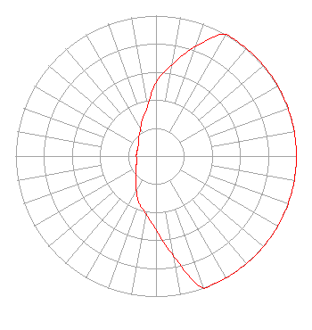 | ||||||||||||||||||
| Azimuth | Ratio | Azimuth | Ratio | Azimuth | Ratio | Azimuth | Ratio | ||||||||||||
| 0 | 0.526 | 10 | 0.662 | 20 | 0.833 | 30 | 1.000 | ||||||||||||
| 40 | 1.000 | 50 | 1.000 | 60 | 1.000 | 70 | 1.000 | ||||||||||||
| 80 | 1.000 | 90 | 1.000 | 100 | 1.000 | 110 | 1.000 | ||||||||||||
| 120 | 1.000 | 130 | 1.000 | 140 | 1.000 | 150 | 1.000 | ||||||||||||
| 160 | 1.000 | 170 | 0.723 | 180 | 0.526 | 190 | 0.418 | ||||||||||||
| 200 | 0.353 | 210 | 0.281 | 220 | 0.222 | 230 | 0.188 | ||||||||||||
| 240 | 0.167 | 250 | 0.146 | 260 | 0.140 | 270 | 0.140 | ||||||||||||
| 280 | 0.140 | 290 | 0.140 | 300 | 0.146 | 310 | 0.161 | ||||||||||||
| 320 | 0.188 | 330 | 0.222 | 340 | 0.281 | 350 | 0.353 | ||||||||||||
Structure Registration Number 1060051 Structure Type: TOWER Registered To: Allfirst Bank Structure Address: Ne Side Of Mitchell St., .5 Mi. W Of Old Landing Rd. Millsboro, DE County Name: Sussex County ASR Issued: 10/24/2000 Date Built: 12/01/1987 Site Elevation: 7.6 m (25 ft.) Structure Height: 97.5 m (320 ft.) Height Overall: 97.5 m (320 ft.) Overall Height AMSL: 105.1 m (345 ft.) FAA Determination: 06/01/1987 FAA Study #: 87-AEA-0626-OE FAA Circular #: 70/7460-1G Paint & Light FAA Chapters: 3, 4, 5, 9 RED LIGHTS/PAINT 38-34-45.0 N 75-17-03.0 W (NAD 83) 38-34-44.6 N 75-17-04.3 W (Converted to NAD 27) |
20254 Dupont Blvd Georgetown, DE 19947 Phone: 302-858-5118 Limited Liability Company | Date: 10/15/2015 Application Certifier GREAT SCOTT BROADCASTING Po Box 417 Millsboro, DE 19966 Applicant S. K. KHANNA Khanna & Guill, Inc. 1203 Woodlea Mill Ct Mclean, VA 22102-2313 CONSULTING ENGINEER DENNIS P. CORBETT, ESQ. Lerman Senter Pllc | |||||||||||||||||
| |||||||||||||||||||