
FCCInfo.com
A Service of Cavell, Mertz & Associates, Inc.
(855) FCC-INFO
|
|
|
|
|
||||||||||||||||
|
|
W264CO Channel: 264D 100.7 MHz Marion, Arkansas Service: FX - A translator or application for a translator. Facility ID: 141904 Fac. Service: FX Programming Delivery Method: Unspecified Status: License Application Accepted: 09/23/2013 Application Granted: 10/30/2013 File Number: BLFT-20130923ADD License Expires: 00/00/0000 Prefix Type: This is a license for a translator Application Type: License To Cover FCC Website Links: LMS Facility Details This Application CDBS Application Other W264CO Applications Other W264CO Applications in CDBS Including Superseded Applications Mailing Address Correspondence for W264CO Correspondence related to application BLFT-20130923ADD Service Contour - Open Street Map or USGS Map (60 dBu) Service Contour - KML / Google Earth (60 dBu) Class: D, A Noncommercial educational operating with no more than 10W Site Location: 34-59-33.3 N 89-54-00.3 W (NAD 83) Site Location: 34-59-33.0 N 89-53-60.0 W (Converted to NAD 27) Effective Radiated Power: 0.25 kW Transmitter Output Power: 0.392 kW Antenna Center HAAT: 90.9 m Horiz.; 0 m Vert. Antenna Center AMSL: 190 m (623 ft.) Antenna Center HAG: 80 m (262 ft.) Site Elevation: 110 m. (361 ft.) Height Overall*: 119 m (390 ft.) (* As Filed In This Application, may differ from ASR Data, Below.) Directional Antenna Antenna Make/Model: None Antenna ID: 112846 Polarization:
| ||||||||||||||||||
| Antenna Data for Antenna Id: 112846 W264CO FX File: BLFT-20130923ADD None - Service: FX | 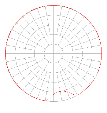 | ||||||||||||||||||
| Azimuth | Ratio | Azimuth | Ratio | Azimuth | Ratio | Azimuth | Ratio | ||||||||||||
| 0 | 1.000 | 10 | 1.000 | 20 | 1.000 | 30 | 1.000 | ||||||||||||
| 40 | 1.000 | 50 | 1.000 | 60 | 1.000 | 70 | 1.000 | ||||||||||||
| 80 | 1.000 | 90 | 1.000 | 100 | 1.000 | 110 | 1.000 | ||||||||||||
| 120 | 1.000 | 130 | 1.000 | 140 | 1.000 | 150 | 1.000 | ||||||||||||
| 160 | 0.850 | 170 | 0.800 | 180 | 0.850 | 190 | 1.000 | ||||||||||||
| 200 | 1.000 | 210 | 1.000 | 220 | 1.000 | 230 | 1.000 | ||||||||||||
| 240 | 1.000 | 250 | 1.000 | 260 | 1.000 | 270 | 1.000 | ||||||||||||
| 280 | 1.000 | 290 | 1.000 | 300 | 1.000 | 310 | 1.000 | ||||||||||||
| 320 | 1.000 | 330 | 1.000 | 340 | 1.000 | 350 | 1.000 | ||||||||||||
Structure Registration Number 1043822 Structure Type: 2TA2 Registered To: Bott Broadcasting Company/Tennessee, Inc. Structure Address: Twr 2 - 0.16 Km E Of Pleasant Hill Rd & 1.37 Km S Of Holmes Rd Southaven, MS County Name: DeSoto County ASR Issued: 03/02/2021 Date Built: 06/01/1991 Site Elevation: 109.7 m (360 ft.) Structure Height: 117.9 m (387 ft.) Height Overall: 118.9 m (390 ft.) Overall Height AMSL: 228.6 m (750 ft.) Paint & Light FAA Chapters: 1, 3, 4, 13, 21 34-59-33.0 N 89-54-00.0 W (NAD 83) 34-59-32.7 N 89-53-59.7 W (Converted to NAD 27) |
10550 Barkley Suite 100 Overland Park, KS 66212 Phone: 913-642-7770 | Date: 09/23/2013 Application Certifier COMMUNITY BROADCASTING, INC. 10550 Barkley Suite 108 Overland Park, KS 66212 Applicant JEREMY D. RUCK, PE Jeremy Ruck & Associates, Inc. P.o. Box 415 Canton, IL 61520 CONSULTING ENGINEER HARRY C. MARTIN Fletcher, Heald & Hildreth, Plc 1300 North 17th Street 11th Floor Arlington, VA 22209 | |||||||||||||||||