
FCCInfo.com
A Service of Cavell, Mertz & Associates, Inc.
(855) FCC-INFO
|
|
|
|
|
||||||||||||||||
|
|
K250BG Channel: 250D 97.9 MHz Hemet, California Service: FX - A translator or application for a translator. Facility ID: 142712 Fac. Service: FX Programming Delivery Method: Unspecified Status: License Application Accepted: 01/20/2015 Application Granted: 02/09/2015 File Number: BLFT-20150120AIP License Expires: 00/00/0000 Prefix Type: This is a license for a translator Application Type: License To Cover FCC Website Links: LMS Facility Details This Application CDBS Application Other K250BG Applications Other K250BG Applications in CDBS Including Superseded Applications Mailing Address Correspondence for K250BG Correspondence related to application BLFT-20150120AIP Service Contour - Open Street Map or USGS Map (60 dBu) Service Contour - KML / Google Earth (60 dBu) Class: D, A Noncommercial educational operating with no more than 10W Site Location: 33-49-49.1 N 116-57-14.1 W (NAD 83) Site Location: 33-49-49.0 N 116-57-11.0 W (Converted to NAD 27) Effective Radiated Power: 0 kW Horiz. ; 0.01 kW Vert. Transmitter Output Power: 0.002 kW Antenna Center HAAT: 470.1 m Horiz.; 0 m Vert. Antenna Center AMSL: 0 m Horiz.; 1170 m Vert. Antenna Center HAG: 0 m Horiz.; 30 m Vert. Site Elevation: 1140 m. (3740 ft.) Height Overall*: 39 m (128 ft.) (* As Filed In This Application, may differ from ASR Data, Below.) Directional Antenna Antenna Make/Model: None Antenna ID: 112913 Polarization:
| ||||||||||||||||||
| Antenna Data for Antenna Id: 112913 K250BG FX File: BLFT-20150120AIP None - Service: FX Pattern and Field Values Include a 180° Clockwise Rotation | 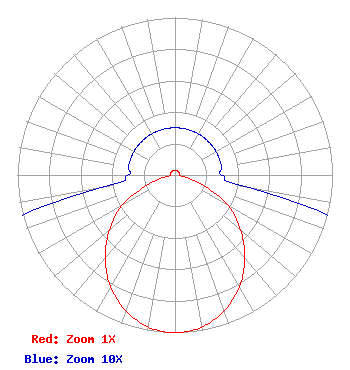 | ||||||||||||||||||
| Azimuth | Ratio | Azimuth | Ratio | Azimuth | Ratio | Azimuth | Ratio | ||||||||||||
| 0 | 0.030 | 10 | 0.030 | 20 | 0.030 | 30 | 0.030 | ||||||||||||
| 40 | 0.030 | 50 | 0.030 | 60 | 0.030 | 70 | 0.030 | ||||||||||||
| 80 | 0.030 | 90 | 0.030 | 100 | 0.050 | 110 | 0.190 | ||||||||||||
| 120 | 0.390 | 130 | 0.544 | 140 | 0.690 | 150 | 0.817 | ||||||||||||
| 160 | 0.916 | 170 | 0.980 | 180 | 1.000 | 190 | 0.980 | ||||||||||||
| 200 | 0.916 | 210 | 0.817 | 220 | 0.690 | 230 | 0.544 | ||||||||||||
| 240 | 0.390 | 250 | 0.190 | 260 | 0.050 | 270 | 0.030 | ||||||||||||
| 280 | 0.030 | 290 | 0.030 | 300 | 0.030 | 310 | 0.030 | ||||||||||||
| 320 | 0.030 | 330 | 0.030 | 340 | 0.030 | 350 | 0.030 | ||||||||||||
Structure Registration Number 1202397 Structure Type: LTOWER Registered To: American Towers LLC Structure Address: 40700 Soboba Road (8672) Banning, CA County Name: Riverside County ASR Issued: 02/04/2015 Date Built: 12/17/1998 Site Elevation: 1139.9 m (3740 ft.) Structure Height: 36.6 m (120 ft.) Height Overall: 39 m (128 ft.) Overall Height AMSL: 1178.9 m (3868 ft.) FAA Determination: 01/09/2015 FAA Study #: 2014-AWP-9445-OE Paint & Light FAA Chapters: NONE PRIOR STUDY 2013-AWP-7665-OE 33-49-49.2 N 116-57-14.1 W (NAD 83) 33-49-49.1 N 116-57-11.0 W (Converted to NAD 27) |
3232 W Macarthur Blvd Santa Ana, CA 92704 Phone: 714-825-9663 | Date: 01/20/2015 Application Certifier PENFOLD COMMUNICATIONS, INC. 35200 Cathedral Canyon Dr. Suite G53 Cathedral City, CA 92234 Applicant ROBERT MOORE 1908 Sweetbriar Dr Goshen, IN 46528 CONSULTING ENGINEER JOHN C. TRENT, ESQ. Putbrese Hunsaker & Trent, P.c. 200 South Church Street Woodstock, VA 22664 | |||||||||||||||||