
FCCInfo.com
A Service of Cavell, Mertz & Associates, Inc.
(855) FCC-INFO
|
|
K289AE from 06/09/1994 |
|
|
||||||||||||||||
|
|
K289AE Channel: 289D 105.7 MHz Owatonna, Minnesota Service: FX - A translator or application for a translator. Facility ID: 42948 Fac. Service: FX Programming Delivery Method: Unspecified Status: License Application Accepted: 08/04/1999 Application Granted: 11/15/1999 File Number: BLFT-19990804TE License Expires: 00/00/0000 Prefix Type: This is a license for a translator Application Type: License To Cover FCC Website Links: LMS Facility Details This Application CDBS Application Other K289AE Applications Other K289AE Applications in CDBS Including Superseded Applications Mailing Address Correspondence for K289AE Correspondence related to application BLFT-19990804TE Service Contour - Open Street Map or USGS Map (60 dBu) Service Contour - KML / Google Earth (60 dBu) Class: D, A Noncommercial educational operating with no more than 10W Site Location: 44-05-18.9 N 93-08-25.7 W (NAD 83) Site Location: 44-05-19.0 N 93-08-25.0 W (Converted to NAD 27) Effective Radiated Power: 0.17 kW Transmitter Output Power: 0.077 kW Antenna Center HAAT: 103 m Horiz.; 0 m Vert. Antenna Center AMSL: 475 m (1558 ft.) Antenna Center HAG: 87 m (285 ft.) Calculated Site Elevation: 388 m. (1273 ft.) Height Overall*: 112 m (367 ft.) (* As Filed In This Application, may differ from ASR Data, Below.) Directional Antenna Antenna Make/Model: None Antenna ID: 16142 Polarization:
| ||||||||||||||||||
| Antenna Data for Antenna Id: 16142 K289AE FX File: BLFT-19990804TE None - Service: FX Pattern and Field Values Include a 260° Clockwise Rotation | 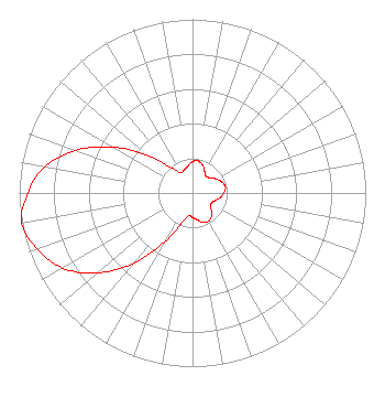 | ||||||||||||||||||
| Azimuth | Ratio | Azimuth | Ratio | Azimuth | Ratio | Azimuth | Ratio | ||||||||||||
| 0 | 0.181 | 10 | 0.187 | 20 | 0.171 | 30 | 0.140 | ||||||||||||
| 40 | 0.123 | 50 | 0.135 | 60 | 0.160 | 70 | 0.182 | ||||||||||||
| 80 | 0.193 | 90 | 0.182 | 100 | 0.160 | 110 | 0.135 | ||||||||||||
| 120 | 0.123 | 130 | 0.140 | 140 | 0.171 | 150 | 0.187 | ||||||||||||
| 160 | 0.181 | 170 | 0.157 | 180 | 0.142 | 190 | 0.134 | ||||||||||||
| 200 | 0.190 | 210 | 0.329 | 220 | 0.528 | 230 | 0.718 | ||||||||||||
| 240 | 0.866 | 250 | 0.952 | 260 | 1.000 | 270 | 0.952 | ||||||||||||
| 280 | 0.866 | 290 | 0.718 | 300 | 0.528 | 310 | 0.329 | ||||||||||||
| 320 | 0.190 | 330 | 0.134 | 340 | 0.142 | 350 | 0.157 | ||||||||||||
Structure Registration Number 1026561 [ASR Heights Differ from K289AE Application] Structure Type: TOWER Structure Address: 4780 County Road 19, 3.5 Mi E Owatonna, MN County Name: Steele County ASR Issued: 04/15/2019 Date Built: 06/15/2004 Site Elevation: 388.6 m (1275 ft.) Structure Height: 106.7 m (350 ft.) Height Overall: 111.6 m (366 ft.) Overall Height AMSL: 500.2 m (1641 ft.) FAA Determination: 05/14/2004 FAA Study #: 2004-AGL-2737-OE FAA Circular #: 70/7460-1K Paint & Light FAA Chapters: 4, 8, 12 PRIOR STUDY 1980-AGL-1030-OE 44-05-19.0 N 93-08-26.0 W (NAD 83) 44-05-19.1 N 93-08-25.3 W (Converted to NAD 27) |
480 Cedar St Saint Paul, MN 55101-2217 Phone: 651-290-1259 | Date: 08/04/1999 Application Certifier MINNESOTA PUBLIC RADIO Minnesota Public Radio, Inc. 45 East Seventh Street St. Paul, MN 55101 Applicant | |||||||||||||||||