
FCCInfo.com
A Service of Cavell, Mertz & Associates, Inc.
(855) FCC-INFO
|
|
|
|  |
|
|||||||||||||||
|
|
KARF Channel: 218C1 91.5 MHz Independence, Kansas Service: FM - A full-service FM station or application. Facility ID: 78930 Fac. Service: FM Status: License Application Accepted: 08/01/2011 Application Granted: 08/04/2011 File Number: BLED-20110801APE License Expires: 00/00/0000 Prefix Type: This is a license for a noncommercial educational FM station Application Type: License To Cover FCC Website Links: LMS Facility Details This Application CDBS Application Other KARF Applications Other KARF Applications in CDBS Including Superseded Applications Mailing Address Correspondence for KARF Correspondence related to application BLED-20110801APE Service Contour - Open Street Map or USGS Map (60 dBu) Service Contour - KML / Google Earth (60 dBu) Public Inspection Files Facility Type: NON-COMMERCIAL EDUC. FM Class: C1, A Zone II station; with 50kW-100kW ERP and a class contour distance 52km-72km Site Location: 37-03-55.3 N 95-45-01.9 W (NAD 83) Site Location: 37-03-55.0 N 95-45-01.0 W (Converted to NAD 27) Effective Radiated Power: 0 kW Horiz. ; 100 kW Vert. Transmitter Output Power: 17.7 kW Antenna Center HAAT: 0 m Horiz.; 100 m Vert. Antenna Center AMSL: 0 m Horiz.; 348 m Vert. Antenna Center HAG: 0 m Horiz.; 106 m Vert. Site Elevation: 242 m. (794 ft.) Height Overall*: 116 m (381 ft.) (* As Filed In This Application, may differ from ASR Data, Below.) Directional Antenna Antenna Make/Model: Electronics Research Inc. P300-4BE-DA Antenna ID: 90041 Polarization:
| ||||||||||||||||||
| Antenna Data for Antenna Id: 90041 KARF FM File: BLED-20110801APE Electronics Research Inc. - P300-4BE-DA Service: FM | 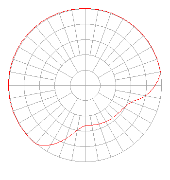 | ||||||||||||||||||
| Azimuth | Ratio | Azimuth | Ratio | Azimuth | Ratio | Azimuth | Ratio | ||||||||||||
| 0 | 1.000 | 10 | 1.000 | 20 | 1.000 | 30 | 1.000 | ||||||||||||
| 40 | 1.000 | 50 | 1.000 | 60 | 1.000 | 70 | 1.000 | ||||||||||||
| 80 | 1.000 | 90 | 0.920 | 100 | 0.800 | 110 | 0.650 | ||||||||||||
| 120 | 0.590 | 130 | 0.570 | 140 | 0.560 | 150 | 0.550 | ||||||||||||
| 160 | 0.540 | 170 | 0.530 | 180 | 0.530 | 190 | 0.600 | ||||||||||||
| 200 | 0.750 | 210 | 0.900 | 220 | 1.000 | 230 | 1.000 | ||||||||||||
| 240 | 1.000 | 250 | 1.000 | 260 | 1.000 | 270 | 1.000 | ||||||||||||
| 280 | 1.000 | 290 | 1.000 | 300 | 1.000 | 310 | 1.000 | ||||||||||||
| 320 | 1.000 | 330 | 1.000 | 340 | 1.000 | 350 | 1.000 | ||||||||||||
Structure Registration Number 1237628 Structure Type: TOWER Registered To: Community Broadcasting, Inc. Structure Address: Intersection Of Cr220 And Cr3500, Independence, Ks Independence, KS County Name: Montgomery County ASR Issued: 02/26/2008 Date Built: 05/27/2007 Site Elevation: 242 m (794 ft.) Structure Height: 114.8 m (377 ft.) Height Overall: 115.8 m (380 ft.) Overall Height AMSL: 357.8 m (1174 ft.) FAA Determination: 03/08/2007 FAA Study #: 2007-ACE-448-OE FAA Circular #: 70/7460-1K Paint & Light FAA Chapters: 3, 4, 5, 12 PRIOR STUDY 2002-ACE-2388-OE 37-03-55.1 N 95-45-01.9 W (NAD 83) 37-03-54.8 N 95-45-01.0 W (Converted to NAD 27) |
10550 Barkley Overland Park, KS 66212 Phone: 913-642-7770 Not-for-Profit | Date: 08/01/2011 Application Certifier COMMUNITY BROADCASTING, INC. 10550 Barkley, Suite 108 Overland Park, KS 66212 Applicant JEREMY D. RUCK, PE D.l. Markley & Associates, Inc. 2104 West Moss Avenue Peoria, IL 61604 CONSULTING ENGINEER HARRY C. MARTIN Fletcher, Heald & Hildreth, Plc | |||||||||||||||||