
FCCInfo.com
A Service of Cavell, Mertz & Associates, Inc.
(855) FCC-INFO
|
|
KLMK from 03/10/1998 |
|
|
||||||||||||||||
|
|
KLMK Channel: 214C2 90.7 MHz Marvell, Arkansas Service: FM - A full-service FM station or application. Facility ID: 84852 Fac. Service: FM Status: License (Licensed And Reduced Power) Application Accepted: 03/05/2010 Application Granted: 03/15/2010 File Number: BLED-20100305AAT License Expires: 00/00/0000 Prefix Type: This is a license for a noncommercial educational FM station Application Type: License To Cover FCC Website Links: LMS Facility Details This Application CDBS Application Other KLMK Applications Other KLMK Applications in CDBS Including Superseded Applications Mailing Address Correspondence for KLMK Correspondence related to application BLED-20100305AAT Service Contour - Open Street Map or USGS Map (60 dBu) Service Contour - KML / Google Earth (60 dBu) Public Inspection Files Facility Type: NON-COMMERCIAL EDUC. FM Class: C2, A Zone II station; with 25kW-50kW ERP and a class contour distance 39km-52km Site Location: 34-37-20.4 N 90-58-44.4 W (NAD 83) Site Location: 34-37-20.0 N 90-58-44.0 W (Converted to NAD 27) Effective Radiated Power: 50 kW Transmitter Output Power: 5.019 kW Antenna Center HAAT: 148 m (486 ft.) Antenna Center AMSL: 201 m (659 ft.) Antenna Center HAG: 146 m (479 ft.) Calculated Site Elevation: 55 m. (180 ft.) Height Overall*: 152 m (499 ft.) (* As Filed In This Application, may differ from ASR Data, Below.) Directional Antenna Antenna Make/Model: Propagation System Inc PSIFM-12-DA Antenna ID: 94072 Polarization:
| ||||||||||||||||||
| Antenna Data for Antenna Id: 94072 KLMK FM File: BLED-20100305AAT Propagation System Inc - PSIFM-12-DA Service: FM | 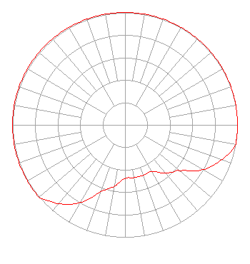 | ||||||||||||||||||
| Azimuth | Ratio | Azimuth | Ratio | Azimuth | Ratio | Azimuth | Ratio | ||||||||||||
| 0 | 1.000 | 10 | 1.000 | 20 | 1.000 | 30 | 1.000 | ||||||||||||
| 40 | 1.000 | 50 | 1.000 | 60 | 1.000 | 70 | 1.000 | ||||||||||||
| 80 | 1.000 | 90 | 1.000 | 100 | 1.000 | 110 | 0.912 | ||||||||||||
| 120 | 0.799 | 130 | 0.635 | 135 | 0.595 | 140 | 0.556 | ||||||||||||
| 150 | 0.477 | 160 | 0.477 | 170 | 0.477 | 180 | 0.477 | ||||||||||||
| 190 | 0.556 | 200 | 0.635 | 210 | 0.799 | 220 | 0.912 | ||||||||||||
| 225 | 0.956 | 230 | 1.000 | 240 | 1.000 | 250 | 1.000 | ||||||||||||
| 260 | 1.000 | 270 | 1.000 | 280 | 1.000 | 290 | 1.000 | ||||||||||||
| 300 | 1.000 | 310 | 1.000 | 320 | 1.000 | 330 | 1.000 | ||||||||||||
| 340 | 1.000 | 350 | 1.000 | ||||||||||||||||
Structure Registration Number 1047874 Structure Type: Registered To: EDUCATIONAL MEDIA FOUNDATION Structure Address: 2.1 Miles North On Pc 145 Marvell, AR County Name: Phillips County ASR Issued: 07/22/2009 Date Built: 05/15/1998 Site Elevation: 55 m (180 ft.) Structure Height: 152 m (499 ft.) Height Overall: 152 m (499 ft.) Overall Height AMSL: 207 m (679 ft.) FAA Determination: 07/10/2009 FAA Study #: 2009-asw-3283-oe FAA Circular #: 70/7460-1K Paint & Light FAA Chapters: 3, 4, 5, 12 PRIOR STUDY 2007-ASW-8039-OE 34-37-20.4 N 90-58-44.4 W (NAD 83) 34-37-20.0 N 90-58-44.0 W (Converted to NAD 27) |
5700 West Oaks Boulevard Rocklin, CA 95765 Phone: 916-251-1600 Not-for-Profit | Date: 03/05/2010 Application Certifier EDUCATIONAL MEDIA FOUNDATION 5700 West Oaks Blvd Rocklin, CA 95765 Applicant SAM WALLINGTON 5700 West Oaks Blvd Rocklin, CA 95765 VP OF ENGINEERING KAREN A. ROSS, ESQ Davis Wright Tremaine Llp | |||||||||||||||||