
FCCInfo.com
A Service of Cavell, Mertz & Associates, Inc.
(855) FCC-INFO
|
|
KVUD from 06/23/2003 KVUD from 09/01/1998 |
|
|
||||||||||||||||
|
|
KVUD Channel: 208C3 89.5 MHz Bay City, Texas Service: FM - A full-service FM station or application. Facility ID: 91535 Fac. Service: FM Analog & Digital Status: License Application Accepted: 02/14/2018 Application Granted: 02/15/2018 File Number: BLED-20180214AAE License Expires: 00/00/0000 Prefix Type: This is a license for a noncommercial educational FM station Application Type: License To Cover FCC Website Links: LMS Facility Details This Application CDBS Application Other KVUD Applications Other KVUD Applications in CDBS Including Superseded Applications Mailing Address Correspondence for KVUD Correspondence related to application BLED-20180214AAE Service Contour - Open Street Map or USGS Map (60 dBu) Service Contour - KML / Google Earth (60 dBu) Public Inspection Files Facility Type: NON-COMMERCIAL EDUC. FM Class: C3, A Zone II station; with 6kW-25kW ERP and a class contour distance 28km-39km Site Location: 28-48-00.9 N 96-07-32.9 W (NAD 83) Site Location: 28-47-59.9 N 96-07-32.0 W (Converted to NAD 27) Effective Radiated Power: 13 kW Transmitter Output Power: 5.41 kW Antenna Center HAAT: 138.2 m (453 ft.) Antenna Center AMSL: 146 m (479 ft.) Antenna Center HAG: 139.3 m (457 ft.) Site Elevation: 6.7 m. (22 ft.) Height Overall*: 463 m (1519 ft.) (* As Filed In This Application, may differ from ASR Data, Below.) Directional Antenna Antenna Make/Model: Electronics Research Inc. LP-6E-DA-HW, 6 sections, 0.5 wavelength spaced Antenna ID: 129253 Polarization: | ||||||||||||||||||
| Antenna Data for Antenna Id: 129253 KVUD FM File: BLED-20180214AAE Electronics Research Inc. - LP-6E-DA-HW, 6 sections, 0.5 wavelength spaced Service: FM | 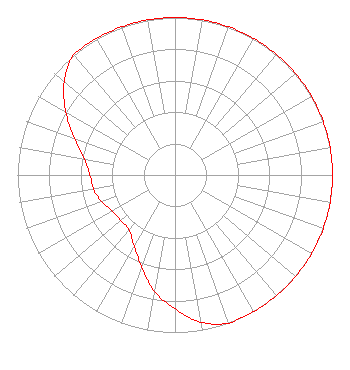 | ||||||||||||||||||
| Azimuth | Ratio | Azimuth | Ratio | Azimuth | Ratio | Azimuth | Ratio | ||||||||||||
| 0 | 1.000 | 10 | 1.000 | 20 | 1.000 | 30 | 1.000 | ||||||||||||
| 40 | 1.000 | 50 | 1.000 | 60 | 1.000 | 70 | 1.000 | ||||||||||||
| 80 | 1.000 | 90 | 1.000 | 100 | 1.000 | 110 | 1.000 | ||||||||||||
| 120 | 1.000 | 130 | 1.000 | 140 | 1.000 | 150 | 1.000 | ||||||||||||
| 160 | 1.000 | 170 | 0.950 | 180 | 0.850 | 190 | 0.750 | ||||||||||||
| 200 | 0.620 | 210 | 0.520 | 220 | 0.455 | 230 | 0.450 | ||||||||||||
| 240 | 0.460 | 250 | 0.495 | 260 | 0.525 | 270 | 0.540 | ||||||||||||
| 280 | 0.585 | 290 | 0.680 | 300 | 0.800 | 310 | 0.920 | ||||||||||||
| 320 | 1.000 | 330 | 1.000 | 340 | 1.000 | 350 | 1.000 | ||||||||||||
Structure Registration Number 1243719 Structure Type: GTOWER Registered To: American Towers LLC Structure Address: Rt 1095 1.8 Km N Of Simpsonville Palacios, TX County Name: Matagorda County ASR Issued: 01/05/2021 Date Built: 03/17/2007 Site Elevation: 6.7 m (22 ft.) Structure Height: 462.1 m (1516 ft.) Height Overall: 463 m (1519 ft.) Overall Height AMSL: 469.7 m (1541 ft.) FAA Determination: 06/12/2013 FAA Study #: 2013-ASW-2940-OE FAA Circular #: 70/7460-1K Paint & Light FAA Chapters: 4, 7, 12 PRIOR STUDY 2003-ASW-6567-OE 28-48-01.0 N 96-07-32.9 W (NAD 83) 28-48-00.0 N 96-07-32.0 W (Converted to NAD 27) |
1722 Treble Drive Humble, TX 77338 Phone: 214-353-9293 Not-for-Profit | Date: 02/14/2018 Application Certifier KSBJ EDUCATIONAL FOUNDATION, INC. 1722 Treble Drive Humble, TX 77338 Applicant JEREMY D. RUCK, PE Jeremy Ruck & Associates, Inc. P.o. Box 415 Canton, IL 61520 CONSULTING ENGINEER DAVINA SASHKIN, ESQ. Fletcher, Heald & Hildreth, Plc | |||||||||||||||||