
FCCInfo.com
A Service of Cavell, Mertz & Associates, Inc.
(855) FCC-INFO
|
|
W224CD from 06/25/2007 W224CD from 07/13/2004 |
|
|
||||||||||||||||
|
|
W224CD Channel: 224D 92.7 MHz Parma, Ohio Service: FX - A translator or application for a translator. Facility ID: 142417 Fac. Service: FX Programming Delivery Method: Unspecified Status: License Application Accepted: 09/21/2015 Application Granted: 10/05/2015 File Number: BLFT-20150921AAI License Expires: 00/00/0000 Prefix Type: This is a license for a translator Application Type: License To Cover FCC Website Links: LMS Facility Details This Application CDBS Application Other W224CD Applications Other W224CD Applications in CDBS Including Superseded Applications Mailing Address Correspondence for W224CD Correspondence related to application BLFT-20150921AAI Service Contour - Open Street Map or USGS Map (60 dBu) Service Contour - KML / Google Earth (60 dBu) Class: D, A Noncommercial educational operating with no more than 10W Site Location: 41-22-58.2 N 81-42-06.5 W (NAD 83) Site Location: 41-22-58.0 N 81-42-07.0 W (Converted to NAD 27) Effective Radiated Power: 0 kW Horiz. ; 0.099 kW Vert. Transmitter Output Power: 0.165 kW Antenna Center HAAT: 278.9 m Horiz.; 0 m Vert. Antenna Center AMSL: 0 m Horiz.; 543 m Vert. Antenna Center HAG: 0 m Horiz.; 232 m Vert. Site Elevation: 311 m. (1020 ft.) Height Overall*: 314 m (1030 ft.) (* As Filed In This Application, may differ from ASR Data, Below.) Directional Antenna Antenna Make/Model: None Antenna ID: 61047 Polarization:
| ||||||||||||||||||
| Antenna Data for Antenna Id: 61047 W224CD FX File: BLFT-20150921AAI None - Service: FX Pattern and Field Values Include a 350° Clockwise Rotation | 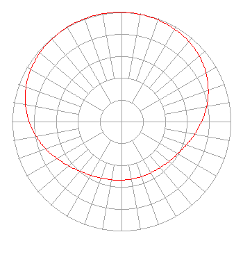 | ||||||||||||||||||
| Azimuth | Ratio | Azimuth | Ratio | Azimuth | Ratio | Azimuth | Ratio | ||||||||||||
| 0 | 0.999 | 10 | 0.995 | 20 | 0.987 | 30 | 0.975 | ||||||||||||
| 40 | 0.956 | 50 | 0.929 | 60 | 0.892 | 70 | 0.845 | ||||||||||||
| 80 | 0.792 | 90 | 0.735 | 100 | 0.679 | 110 | 0.630 | ||||||||||||
| 120 | 0.592 | 130 | 0.566 | 140 | 0.549 | 150 | 0.540 | ||||||||||||
| 160 | 0.535 | 170 | 0.534 | 180 | 0.535 | 190 | 0.540 | ||||||||||||
| 200 | 0.549 | 210 | 0.566 | 220 | 0.592 | 230 | 0.630 | ||||||||||||
| 240 | 0.679 | 250 | 0.735 | 260 | 0.792 | 270 | 0.845 | ||||||||||||
| 280 | 0.892 | 290 | 0.929 | 300 | 0.956 | 310 | 0.975 | ||||||||||||
| 320 | 0.987 | 330 | 0.995 | 340 | 0.999 | 350 | 1.000 | ||||||||||||
Structure Registration Number 1012992 Structure Type: TOWER Registered To: Univision Television Group, Inc. Structure Address: 2861 W Ridgewood Dr Cleveland, OH County Name: Cuyahoga County ASR Issued: 10/18/2007 Date Built: 09/03/1980 Site Elevation: 310.6 m (1019 ft.) Structure Height: 299.2 m (982 ft.) Height Overall: 313.9 m (1030 ft.) Overall Height AMSL: 624.5 m (2049 ft.) FAA Determination: 03/02/1997 FAA Study #: 97-AGL-0600-OE FAA Circular #: 70/7460-1J Paint & Light FAA Chapters: 3, 4, 5, 13 41-22-58.0 N 81-42-06.0 W (NAD 83) 41-22-57.8 N 81-42-06.5 W (Converted to NAD 27) |
5700 West Oaks Blvd Rocklin, CA 95765 Phone: 916-251-1600 | Date: 09/21/2015 Application Certifier EDUCATIONAL MEDIA FOUNDATION 5700 West Oaks Blvd Rocklin, CA 95765 Applicant STEPHEN WILDE 5700 West Oaks Blvd Rocklin, CA 95765 RF DESIGN ENGINEER MARY N. O'CONNOR Educational Media Foundation 2300 N. Street, N.w. Washington, DC 20037-1128 | |||||||||||||||||