
FCCInfo.com
A Service of Cavell, Mertz & Associates, Inc.
(855) FCC-INFO
|
|
KXFG from 05/13/1992 |
|
|
||||||||||||||||
|
|
KXFG Channel: 225A 92.9 MHz Menifee, California Service: FM - A full-service FM station or application. Facility ID: 63912 Fac. Service: FM Analog & Digital Status: License Application Accepted: 03/01/2013 Application Granted: 03/07/2013 File Number: BMLH-20130301ABD License Expires: 00/00/0000 Prefix Type: This is a modification of a license for a commecial FM station Application Type: Minor Modification FCC Website Links: LMS Facility Details This Application CDBS Application Other KXFG Applications Other KXFG Applications in CDBS Including Superseded Applications Mailing Address Correspondence for KXFG Correspondence related to application BMLH-20130301ABD Service Contour - Open Street Map or USGS Map (60 dBu) Service Contour - KML / Google Earth (60 dBu) Public Inspection Files Facility Type: FM STATION Class: A, A Zone I; I-A; or II station; with 0.1kW-6kW ERP and a class contour distance <=28km Site Location: 33-35-34.4 N 117-08-53.9 W (NAD 83) Site Location: 33-35-34.3 N 117-08-50.8 W (Converted to NAD 27) Effective Radiated Power: 6 kW Transmitter Output Power: 6.7 kW Antenna Center HAAT: 100 m (328 ft.) Antenna Center AMSL: 562 m (1844 ft.) Antenna Center HAG: 35 m (115 ft.) Site Elevation: 527 m. (1729 ft.) Height Overall*: 40.2 m (132 ft.) (* As Filed In This Application, may differ from ASR Data, Below.) Directional Antenna Antenna Make/Model: Electronics Research Inc. LP-2E-DA-HW, 2 SECTIONS, 0.5 WAVELENGTH SPACING Antenna ID: 102322 Polarization: | ||||||||||||||||||
| Antenna Data for Antenna Id: 102322 KXFG FM File: BMLH-20130301ABD Electronics Research Inc. - LP-2E-DA-HW, 2 SECTIONS, 0.5 WAVELENGTH SPACING Service: FM | 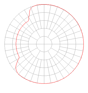 | ||||||||||||||||||
| Azimuth | Ratio | Azimuth | Ratio | Azimuth | Ratio | Azimuth | Ratio | ||||||||||||
| 0 | 1.000 | 10 | 1.000 | 20 | 1.000 | 30 | 1.000 | ||||||||||||
| 40 | 1.000 | 50 | 1.000 | 60 | 1.000 | 70 | 1.000 | ||||||||||||
| 80 | 1.000 | 90 | 1.000 | 100 | 1.000 | 110 | 1.000 | ||||||||||||
| 120 | 1.000 | 130 | 1.000 | 140 | 1.000 | 150 | 1.000 | ||||||||||||
| 160 | 1.000 | 170 | 1.000 | 180 | 1.000 | 190 | 1.000 | ||||||||||||
| 200 | 1.000 | 210 | 1.000 | 220 | 1.000 | 230 | 0.930 | ||||||||||||
| 240 | 0.745 | 243 | 0.707 | 250 | 0.707 | 260 | 0.707 | ||||||||||||
| 270 | 0.707 | 280 | 0.707 | 290 | 0.707 | 300 | 0.707 | ||||||||||||
| 310 | 0.707 | 320 | 0.707 | 326 | 0.707 | 330 | 0.775 | ||||||||||||
| 340 | 0.960 | 350 | 1.000 | ||||||||||||||||
Structure Registration Number 1016098 Structure Type: GTOWER Registered To: American Towers LLC Structure Address: 29405 Crawford Canyon Road (hog Backs #4473) Murrieta, CA County Name: Riverside County ASR Issued: 08/11/2022 Date Built: 08/01/2003 Site Elevation: 527.3 m (1730 ft.) Structure Height: 39.9 m (131 ft.) Height Overall: 40.2 m (132 ft.) Overall Height AMSL: 567.5 m (1862 ft.) FAA Determination: 08/10/2022 FAA Study #: 2022-AWP-4170-OE FAA Circular #: 70/7460-1K Paint & Light FAA Chapters: 4, 8, 12 OM&L to remain the same as prior study = A MED-DUAL SYSTEM 33-35-34.4 N 117-08-53.9 W (NAD 83) 33-35-34.3 N 117-08-50.8 W (Converted to NAD 27) |
2400 Market Street 4th Floor Philadelphia, PA 19103 Phone: 610-660-5610 Limited Liability Company | Date: 03/01/2013 Application Certifier CBS RADIO STATIONS INC. Ste 920 1800 K St Nw Washington, DC 20006 Applicant RAYMOND BENEDICT Cbs Operations Inc. 1800 K Street Nw Suite 920 Washington, DC 20006 EMPLOYEE OF PARENT CORPORATION RAYMOND BENEDICT Cbs | |||||||||||||||||