
FCCInfo.com
A Service of Cavell, Mertz & Associates, Inc.
(855) FCC-INFO
|
|
|
|
|
||||||||||||||||
|
|
W235AA Channel: 235D 94.9 MHz Wilkes-barre, Pennsylvania Service: FX - A translator or application for a translator. Facility ID: 65185 Fac. Service: FX Programming Delivery Method: Unspecified Status: License Application Accepted: 06/30/2006 Application Granted: 08/31/2006 File Number: BLFT-20060630ACU License Expires: 00/00/0000 Prefix Type: This is a license for a translator Application Type: License To Cover FCC Website Links: LMS Facility Details This Application CDBS Application Other W235AA Applications Other W235AA Applications in CDBS Including Superseded Applications Mailing Address Correspondence for W235AA Correspondence related to application BLFT-20060630ACU Service Contour - Open Street Map or USGS Map (60 dBu) Service Contour - KML / Google Earth (60 dBu) Class: D, A Noncommercial educational operating with no more than 10W Site Location: 41-11-11.3 N 75-51-31.7 W (NAD 83) Site Location: 41-11-11.0 N 75-51-33.0 W (Converted to NAD 27) Effective Radiated Power: 0.01 kW Transmitter Output Power: 0.02 kW Antenna Center HAAT: 286.8 m Horiz.; 0 m Vert. Antenna Center AMSL: 683 m (2241 ft.) Antenna Center HAG: 73 m (240 ft.) Site Elevation: 610 m. (2001 ft.) Height Overall*: 87 m (285 ft.) (* As Filed In This Application, may differ from ASR Data, Below.) Directional Antenna Antenna Make/Model: None Antenna ID: 71782 Polarization:
| ||||||||||||||||||
| Antenna Data for Antenna Id: 71782 W235AA FX File: BLFT-20060630ACU None - Service: FX Pattern and Field Values Include a 355° Clockwise Rotation | 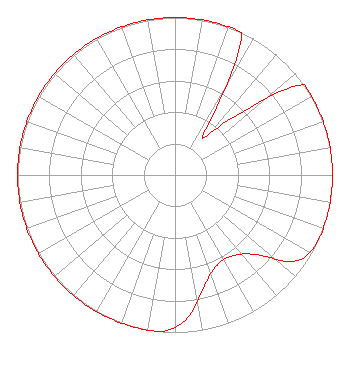 | ||||||||||||||||||
| Azimuth | Ratio | Azimuth | Ratio | Azimuth | Ratio | Azimuth | Ratio | ||||||||||||
| 5 | 1.000 | 15 | 1.000 | 25 | 1.000 | 35 | 0.320 | ||||||||||||
| 45 | 0.510 | 55 | 1.000 | 65 | 1.000 | 75 | 1.000 | ||||||||||||
| 85 | 1.000 | 95 | 1.000 | 105 | 1.000 | 115 | 1.000 | ||||||||||||
| 125 | 0.947 | 135 | 0.713 | 145 | 0.630 | 155 | 0.631 | ||||||||||||
| 165 | 0.725 | 175 | 0.910 | 185 | 1.000 | 195 | 1.000 | ||||||||||||
| 205 | 1.000 | 215 | 1.000 | 225 | 1.000 | 235 | 1.000 | ||||||||||||
| 245 | 1.000 | 255 | 1.000 | 265 | 1.000 | 275 | 1.000 | ||||||||||||
| 285 | 1.000 | 295 | 1.000 | 305 | 1.000 | 315 | 1.000 | ||||||||||||
| 325 | 1.000 | 335 | 1.000 | 345 | 1.000 | 355 | 1.000 | ||||||||||||
Structure Registration Number 1201213 Structure Type: TOWER Registered To: The Scranton Times, L.P. Structure Address: Penobscot Mountain, 1000 Sterling Street Mountain Top, PA County Name: Luzerne County ASR Issued: 03/24/2011 Date Built: 12/22/2000 Site Elevation: 609.6 m (2000 ft.) Structure Height: 85.3 m (280 ft.) Height Overall: 86.9 m (285 ft.) Overall Height AMSL: 696.5 m (2285 ft.) FAA Determination: 07/19/1999 FAA Study #: 98-AEA-3690-OE FAA Circular #: 70/7460-1J Paint & Light FAA Chapters: 4, 8, 13 Removed expiration date from determination. Scenario 1./jjs/case#635066 41-11-11.3 N 75-51-31.7 W (NAD 83) 41-11-11.0 N 75-51-33.0 W (Converted to NAD 27) |
1509 Cecil B. Moore Avenue Wrti/third Floor Philadelphia, PA 19121-3410 Phone: 215-204-8405 | Date: 06/30/2006 Application Certifier TEMPLE UNIVERSITY OF THE COMMONWEALTH SYSTEM OF HIGHER ED 1509 Cecil B. Moore Avenue Wrti/third Floor Philadelphia, PA 19121-3410 Applicant JEFF DEPOLO Broadcast Sciences 1465 Horseshoe Trail Malvern, PA 19355 CONSULTANT PETER TANNENWALD Irwin, Campbell & Tannenwald, P.c. 1730 Rhode Island Ave., Nw Suite 200 Washington, DC 20036-3120 | |||||||||||||||||