
FCCInfo.com
A Service of Cavell, Mertz & Associates, Inc.
(855) FCC-INFO
|
|
KCKR from 10/23/1996 |
|  |
|
|||||||||||||||
|
|
KCKR Channel: 220C3 91.9 MHz Church Point, Louisiana Service: FM - A full-service FM station or application. Facility ID: 83852 Fac. Service: FM Status: License 73.215 Station Application Accepted: 07/14/2008 Application Granted: 10/10/2008 File Number: BMLED-20080714ACA License Expires: 00/00/0000 Prefix Type: This is a modification of license for a noncommercial educational FM station Application Type: Minor Modification FCC Website Links: LMS Facility Details This Application CDBS Application Other KCKR Applications Other KCKR Applications in CDBS Including Superseded Applications Mailing Address Correspondence for KCKR Correspondence related to application BMLED-20080714ACA Service Contour - Open Street Map or USGS Map (60 dBu) Service Contour - KML / Google Earth (60 dBu) Public Inspection Files Facility Type: NON-COMMERCIAL EDUC. FM Class: C3, A Zone II station; with 6kW-25kW ERP and a class contour distance 28km-39km Site Location: 30-19-47.7 N 92-05-06.4 W (NAD 83) Site Location: 30-19-47.0 N 92-05-06.0 W (Converted to NAD 27) Effective Radiated Power: 12.5 kW Horiz. ; 12.4 kW Vert. Transmitter Output Power: 6.401 kW Antenna Center HAAT: 141.9 m (466 ft.) Antenna Center AMSL: 150.5 m (494 ft.) Antenna Center HAG: 138.4 m (454 ft.) Calculated Site Elevation: 12.1 m. (40 ft.) Height Overall*: 152.4 m (500 ft.) (* As Filed In This Application, may differ from ASR Data, Below.) Directional Antenna Antenna Make/Model: Shivley 6810-3-DA, THREE SECTIONS, ONE SPACING Antenna ID: 78481 Polarization:
| ||||||||||||||||||
| Antenna Data for Antenna Id: 78481 KCKR FM File: BMLED-20080714ACA Shivley - 6810-3-DA, THREE SECTIONS, ONE SPACING Service: FM | 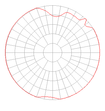 | ||||||||||||||||||
| Azimuth | Ratio | Azimuth | Ratio | Azimuth | Ratio | Azimuth | Ratio | ||||||||||||
| 0 | 0.780 | 10 | 0.780 | 20 | 0.900 | 30 | 0.900 | ||||||||||||
| 40 | 0.900 | 45 | 1.000 | 50 | 0.900 | 60 | 1.000 | ||||||||||||
| 70 | 1.000 | 80 | 1.000 | 90 | 1.000 | 100 | 1.000 | ||||||||||||
| 110 | 1.000 | 120 | 1.000 | 130 | 1.000 | 135 | 1.000 | ||||||||||||
| 140 | 1.000 | 150 | 1.000 | 160 | 1.000 | 170 | 1.000 | ||||||||||||
| 180 | 0.950 | 190 | 0.950 | 200 | 1.000 | 210 | 1.000 | ||||||||||||
| 220 | 1.000 | 225 | 1.000 | 230 | 1.000 | 240 | 1.000 | ||||||||||||
| 250 | 1.000 | 260 | 1.000 | 270 | 1.000 | 280 | 1.000 | ||||||||||||
| 290 | 1.000 | 300 | 1.000 | 310 | 1.000 | 315 | 1.000 | ||||||||||||
| 320 | 1.000 | 330 | 1.000 | 340 | 1.000 | 350 | 0.900 | ||||||||||||
Structure Registration Number 1020855 Structure Type: TOWER Registered To: Telcom Properties Structure Address: 102 Cockpit Rd Or 2.5 Mi Wnw Carencro, LA County Name: Lafayette Parish ASR Issued: 06/05/2019 Date Built: 05/28/1983 Site Elevation: 12.1 m (40 ft.) Structure Height: 152.4 m (500 ft.) Height Overall: 152.4 m (500 ft.) Overall Height AMSL: 164.5 m (540 ft.) FAA Determination: 07/28/1982 FAA Study #: 82-ASW-1967-OE FAA Circular #: 70/7460-1F Paint & Light FAA Chapters: 3, 4, 5, 9 RED LIGHTS/PAINT 30-19-48.0 N 92-05-06.0 W (NAD 83) 30-19-47.3 N 92-05-05.6 W (Converted to NAD 27) |
8919 World Ministry Avenue Baton Rouge, LA 70826 Phone: 225-768-3102 | Date: 07/14/2008 Application Certifier FAMILY WORSHIP CENTER CHURCH, INC. P.o. Box 262550 Baton Rouge, LA 70810 Applicant JOHN C. TRENT Putbrese Hunsker & Trent, P.c. 200 South Church Street Woodstock, VA 22664 COUNSEL JOHN C. TRENT, ESQUIRE Putbrese Hunsaker & Trent, P.c. | |||||||||||||||||