
FCCInfo.com
A Service of Cavell, Mertz & Associates, Inc.
(855) FCC-INFO
|
|
|
|  |
|
|||||||||||||||
|
|
WNFC Channel: 219C3 91.7 MHz Paducah, Kentucky Service: FM - A full-service FM station or application. Facility ID: 175623 Fac. Service: FM Status: License Application Accepted: 10/28/2010 Application Granted: 12/16/2010 File Number: BLED-20101028AAH License Expires: 00/00/0000 Prefix Type: This is a license for a noncommercial educational FM station Application Type: Amendment FCC Website Links: LMS Facility Details This Application CDBS Application Other WNFC Applications Other WNFC Applications in CDBS Including Superseded Applications Mailing Address Correspondence for WNFC Correspondence related to application BLED-20101028AAH Service Contour - Open Street Map or USGS Map (60 dBu) Service Contour - KML / Google Earth (60 dBu) Public Inspection Files Facility Type: NON-COMMERCIAL EDUC. FM Class: C3, A Zone II station; with 6kW-25kW ERP and a class contour distance 28km-39km Site Location: 37-03-41.6 N 88-50-25.9 W (NAD 83) Site Location: 37-03-41.4 N 88-50-25.7 W (Converted to NAD 27) Effective Radiated Power: 15 kW Transmitter Output Power: 3.689 kW Antenna Center HAAT: 90.4 m (297 ft.) Antenna Center AMSL: 207.3 m (680 ft.) Antenna Center HAG: 70.1 m (230 ft.) Calculated Site Elevation: 137.2 m. (450 ft.) Height Overall*: 74.1 m (243 ft.) (* As Filed In This Application, may differ from ASR Data, Below.) Directional Antenna Antenna Make/Model: Shivley 6810-3R-DA, three sections Antenna ID: 98566 Polarization:
| ||||||||||||||||||
| Antenna Data for Antenna Id: 98566 WNFC FM File: BLED-20101028AAH Shivley - 6810-3R-DA, three sections Service: FM | 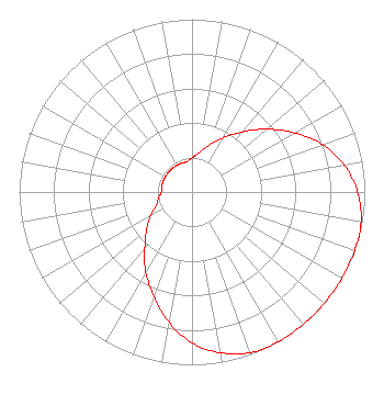 | ||||||||||||||||||
| Azimuth | Ratio | Azimuth | Ratio | Azimuth | Ratio | Azimuth | Ratio | ||||||||||||
| 0 | 0.197 | 10 | 0.230 | 20 | 0.288 | 30 | 0.362 | ||||||||||||
| 40 | 0.455 | 50 | 0.566 | 60 | 0.685 | 70 | 0.804 | ||||||||||||
| 80 | 0.896 | 90 | 0.958 | 100 | 0.994 | 110 | 1.000 | ||||||||||||
| 120 | 1.000 | 130 | 1.000 | 140 | 1.000 | 150 | 1.000 | ||||||||||||
| 160 | 0.990 | 170 | 0.945 | 180 | 0.873 | 190 | 0.766 | ||||||||||||
| 200 | 0.644 | 210 | 0.535 | 220 | 0.425 | 230 | 0.343 | ||||||||||||
| 240 | 0.277 | 250 | 0.220 | 260 | 0.197 | 270 | 0.178 | ||||||||||||
| 280 | 0.178 | 290 | 0.178 | 300 | 0.178 | 310 | 0.178 | ||||||||||||
| 320 | 0.178 | 330 | 0.178 | 340 | 0.178 | 350 | 0.178 | ||||||||||||
Structure Registration Number 1268748 Structure Type: TOWER Registered To: SOMERSET EDUCATIONAL BROADCASTING FOUNDATION Structure Address: 0.36 Mi Se Of Intersection Of Lester Harris Rd & Rachel Dr Kevil, KY County Name: McCracken County ASR Issued: 03/27/2015 Date Built: 06/29/2010 Site Elevation: 137.2 m (450 ft.) Structure Height: 73.2 m (240 ft.) Height Overall: 74.1 m (243 ft.) Overall Height AMSL: 211.3 m (693 ft.) FAA Determination: 05/12/2009 FAA Study #: 2009-ASO-317-OE FAA Circular #: 70/7460-1K Paint & Light FAA Chapters: 3, 4, 5, 12 Removed expiration and final dates from determination. Scenario 2./jjs/case#635066 37-03-41.6 N 88-50-25.9 W (NAD 83) 37-03-41.4 N 88-50-25.7 W (Converted to NAD 27) |
P.o. Box 1423 Somerset, KY 42502 Phone: 606-679-6300 | Date: 10/28/2010 Application Certifier FM 90.1, INC. P.o. Box 91 Upton, KY 42784 Applicant JOHN NEELY Suite 704 6900 Wisconsin Ave. Bethesda, MD 20815 COUNSEL JOHN NEELY, ESQ. Miller And Neely, P.c. | |||||||||||||||||