
FCCInfo.com
A Service of Cavell, Mertz & Associates, Inc.
(855) FCC-INFO
|
|
KTUA from 01/06/2003 KTUA from 04/12/1996 |
|  |
|
|||||||||||||||
|
|
KTUA Channel: 201C1 88.1 MHz Coweta, Oklahoma Service: FM - A full-service FM station or application. Facility ID: 81516 Fac. Service: FM Status: License Application Accepted: 04/12/2017 Application Granted: 05/02/2017 File Number: BLED-20170412AAD License Expires: 00/00/0000 Prefix Type: This is a license for a noncommercial educational FM station Application Type: License To Cover FCC Website Links: LMS Facility Details This Application CDBS Application Other KTUA Applications Other KTUA Applications in CDBS Including Superseded Applications Mailing Address Correspondence for KTUA Correspondence related to application BLED-20170412AAD Service Contour - Open Street Map or USGS Map (60 dBu) Service Contour - KML / Google Earth (60 dBu) Public Inspection Files Facility Type: NON-COMMERCIAL EDUC. FM Class: C1, A Zone II station; with 50kW-100kW ERP and a class contour distance 52km-72km Site Location: 36-07-55.3 N 96-14-24.0 W (NAD 83) Site Location: 36-07-55.0 N 96-14-23.0 W (Converted to NAD 27) Effective Radiated Power: 100 kW Transmitter Output Power: 12.9 kW Antenna Center HAAT: 136 m (446 ft.) Antenna Center AMSL: 384 m (1260 ft.) Antenna Center HAG: 103.6 m (340 ft.) Site Elevation: 280.4 m. (920 ft.) Height Overall*: 121.9 m (400 ft.) (* As Filed In This Application, may differ from ASR Data, Below.) Directional Antenna Antenna Make/Model: DIELECTRIC DCRM7CD, seven sections Antenna ID: 124974 Polarization: | ||||||||||||||||||
| Antenna Data for Antenna Id: 124974 KTUA FM File: BLED-20170412AAD DIELECTRIC - DCRM7CD, seven sections Service: FM | 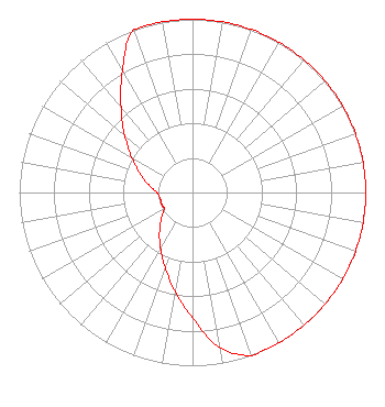 | ||||||||||||||||||
| Azimuth | Ratio | Azimuth | Ratio | Azimuth | Ratio | Azimuth | Ratio | ||||||||||||
| 0 | 1.000 | 10 | 1.000 | 20 | 1.000 | 30 | 1.000 | ||||||||||||
| 40 | 1.000 | 50 | 1.000 | 60 | 1.000 | 70 | 1.000 | ||||||||||||
| 80 | 1.000 | 90 | 1.000 | 100 | 1.000 | 110 | 1.000 | ||||||||||||
| 120 | 1.000 | 130 | 1.000 | 140 | 1.000 | 150 | 1.000 | ||||||||||||
| 160 | 1.000 | 170 | 0.909 | 180 | 0.726 | 190 | 0.580 | ||||||||||||
| 200 | 0.463 | 210 | 0.371 | 220 | 0.296 | 230 | 0.236 | ||||||||||||
| 240 | 0.190 | 250 | 0.190 | 260 | 0.190 | 270 | 0.206 | ||||||||||||
| 280 | 0.257 | 290 | 0.323 | 300 | 0.406 | 310 | 0.511 | ||||||||||||
| 320 | 0.642 | 330 | 0.808 | 340 | 1.000 | 350 | 1.000 | ||||||||||||
Structure Registration Number 1218989 Structure Type: LTOWER Registered To: Educational Media Foundation Structure Address: 22400 W. Highway 51 Sand Springs, OK County Name: Tulsa County ASR Issued: 12/08/2021 Date Built: 04/07/2017 Site Elevation: 280.1 m (919 ft.) Structure Height: 96.6 m (317 ft.) Height Overall: 121.9 m (400 ft.) Overall Height AMSL: 402 m (1319 ft.) FAA Determination: 01/21/2016 FAA Study #: 2015-ASW-9775-OE FAA Circular #: 70/7460-1L Paint & Light FAA Chapters: 4, 8, 12 Removed expiration date from determination. Scenario 1./jjs/case#635066 36-07-55.0 N 96-14-24.0 W (NAD 83) 36-07-54.7 N 96-14-23.0 W (Converted to NAD 27) |
5700 West Oaks Blvd. Rocklin, CA 95765 Phone: 916-251-1600 Private Not-for-Profit Educational Institution | Date: 04/12/2017 Application Certifier CREATIVE EDUCATIONAL MEDIA CORPORATION, INC. P.o. Box 1924 Tulsa, OK 74101 Applicant CLARENCE M BEVERAGE Communications Technologies, Inc. P.o. Box 1130 Marlton, NJ 08053 BROADCAST ENGINEERING CONSULTANT CARY S. TEPPER, ESQ. Tepper Law Firm, Llc | |||||||||||||||||