
FCCInfo.com
A Service of Cavell, Mertz & Associates, Inc.
(855) FCC-INFO
|
|
WHGN from 09/23/1992 |
|  |
|
|||||||||||||||
|
|
WHGN Channel: 220C2 91.9 MHz Crystal River, Florida Service: FM - A full-service FM station or application. Facility ID: 11026 Fac. Service: FM Status: License Application Accepted: 02/07/2002 Application Granted: 04/02/2003 File Number: BLED-20020207AAS License Expires: 00/00/0000 Prefix Type: This is a license for a noncommercial educational FM station Application Type: License To Cover FCC Website Links: LMS Facility Details This Application CDBS Application Other WHGN Applications Other WHGN Applications in CDBS Including Superseded Applications Mailing Address Correspondence for WHGN Correspondence related to application BLED-20020207AAS Service Contour - Open Street Map or USGS Map (60 dBu) Service Contour - KML / Google Earth (60 dBu) Public Inspection Files Facility Type: NON-COMMERCIAL EDUC. FM Class: C2, A Zone II station; with 25kW-50kW ERP and a class contour distance 39km-52km Site Location: 28-50-29.9 N 82-30-20.4 W (NAD 83) Site Location: 28-50-29.0 N 82-30-21.0 W (Converted to NAD 27) Effective Radiated Power: 41 kW Horiz. ; 39.3 kW Vert. Transmitter Output Power: 16.97 kW Antenna Center HAAT: 165 m (541 ft.) Antenna Center AMSL: 165 m (541 ft.) Antenna Center HAG: 140 m (459 ft.) Site Elevation: 25 m. (82 ft.) Height Overall*: 147 m (482 ft.) (* As Filed In This Application, may differ from ASR Data, Below.) Directional Antenna Antenna Make/Model: Electronics Research Inc. MP-4E-DA-HW Antenna ID: 33601 Polarization:
| ||||||||||||||||||
| Antenna Data for Antenna Id: 33601 WHGN FM File: BLED-20020207AAS Electronics Research Inc. - MP-4E-DA-HW Service: FM | 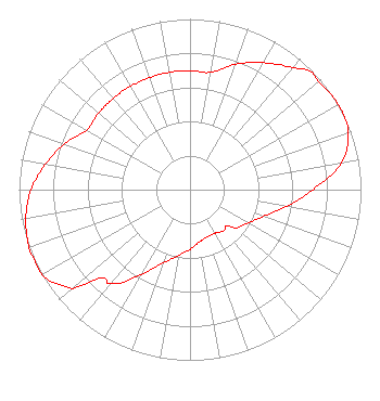 | ||||||||||||||||||
| Azimuth | Ratio | Azimuth | Ratio | Azimuth | Ratio | Azimuth | Ratio | ||||||||||||
| 0 | 0.698 | 10 | 0.698 | 20 | 0.783 | 30 | 0.858 | ||||||||||||
| 40 | 0.930 | 45 | 0.985 | 50 | 0.985 | 60 | 1.000 | ||||||||||||
| 70 | 0.985 | 80 | 0.899 | 90 | 0.718 | 100 | 0.573 | ||||||||||||
| 110 | 0.458 | 120 | 0.392 | 130 | 0.350 | 135 | 0.299 | ||||||||||||
| 140 | 0.311 | 150 | 0.294 | 160 | 0.294 | 170 | 0.311 | ||||||||||||
| 180 | 0.350 | 190 | 0.392 | 200 | 0.458 | 210 | 0.573 | ||||||||||||
| 220 | 0.718 | 225 | 0.732 | 230 | 0.899 | 240 | 1.000 | ||||||||||||
| 250 | 1.000 | 260 | 0.975 | 270 | 0.930 | 280 | 0.858 | ||||||||||||
| 290 | 0.783 | 300 | 0.698 | 310 | 0.698 | 315 | 0.698 | ||||||||||||
| 320 | 0.698 | 330 | 0.698 | 340 | 0.698 | 350 | 0.698 | ||||||||||||
Structure Registration Number 1217420 Structure Type: GTOWER Registered To: Moody Bible Institiute Structure Address: .50 Miles Southwest Of Hwy 44 & Route 490 Lecanto, FL County Name: Citrus County ASR Issued: 03/09/2024 Date Built: 02/16/2023 Site Elevation: 24.7 m (81 ft.) Structure Height: 146.3 m (480 ft.) Height Overall: 147.2 m (483 ft.) Overall Height AMSL: 171.9 m (564 ft.) FAA Determination: 01/31/2024 FAA Study #: 2023-ASO-10997-OE FAA Circular #: 70/7460-1M Paint & Light FAA Chapters: 4, 8, 15 PRIOR STUDY 2002-ASO-874-OE 28-50-30.2 N 82-30-20.4 W (NAD 83) 28-50-29.3 N 82-30-21.0 W (Converted to NAD 27) |
820 N Lasalle St Chicago, IL 60610-3214 Phone: 312-329-4438 Private Not-for-Profit Educational Institution | Date: 02/07/2002 Application Certifier SEVEN RIVERS BROADCAST MINISTRY, INC. 1566 N. Meadowcrest Boulevard Crystal River, FL 34429 Applicant JEFFERSON G. BROCK P.o. Box 24466 St. Simons Island, GA 31522-7466 TECHNICAL CONSULTANT | |||||||||||||||||
| |||||||||||||||||||