
FCCInfo.com
A Service of Cavell, Mertz & Associates, Inc.
(855) FCC-INFO
|
|
W223CU from 05/01/2013 |
|
|
||||||||||||||||
|
|
W223CU Channel: 223D 92.5 MHz Richmond, Kentucky Service: FX - A translator or application for a translator. Facility ID: 155988 Fac. Service: FX Programming Delivery Method: Unspecified Status: License Application Accepted: 01/19/2017 Application Granted: 01/30/2017 File Number: BLFT-20170119ABJ License Expires: 00/00/0000 Prefix Type: This is a license for a translator Application Type: License To Cover FCC Website Links: LMS Facility Details This Application CDBS Application Other W223CU Applications Other W223CU Applications in CDBS Including Superseded Applications Mailing Address Correspondence for W223CU Correspondence related to application BLFT-20170119ABJ Service Contour - Open Street Map or USGS Map (60 dBu) Service Contour - KML / Google Earth (60 dBu) Class: D, A Noncommercial educational operating with no more than 10W Site Location: 37-39-36.3 N 84-08-59.7 W (NAD 83) Site Location: 37-39-36.0 N 84-08-60.0 W (Converted to NAD 27) Effective Radiated Power: 0.225 kW Transmitter Output Power: 0.549 kW Antenna Center HAAT: 0 m Antenna Center AMSL: 417 m (1368 ft.) Antenna Center HAG: 127 m (417 ft.) Site Elevation: 290 m. (951 ft.) Height Overall*: 152 m (499 ft.) (* As Filed In This Application, may differ from ASR Data, Below.) Directional Antenna Antenna Make/Model: None Antenna ID: 123332 Polarization:
| ||||||||||||||||||
| Antenna Data for Antenna Id: 123332 W223CU FX File: BLFT-20170119ABJ None - Service: FX | 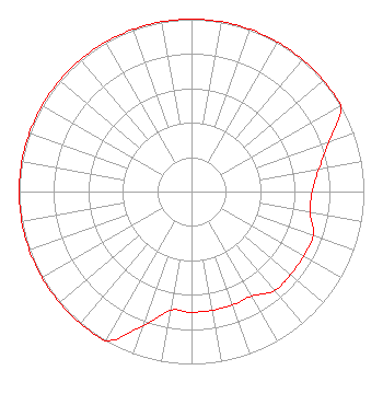 | ||||||||||||||||||
| Azimuth | Ratio | Azimuth | Ratio | Azimuth | Ratio | Azimuth | Ratio | ||||||||||||
| 0 | 1.000 | 10 | 1.000 | 20 | 1.000 | 30 | 1.000 | ||||||||||||
| 40 | 1.000 | 50 | 1.000 | 60 | 1.000 | 70 | 0.850 | ||||||||||||
| 80 | 0.750 | 90 | 0.700 | 100 | 0.700 | 110 | 0.750 | ||||||||||||
| 120 | 0.750 | 130 | 0.750 | 140 | 0.750 | 150 | 0.700 | ||||||||||||
| 160 | 0.700 | 170 | 0.700 | 180 | 0.700 | 190 | 0.700 | ||||||||||||
| 200 | 0.830 | 210 | 1.000 | 220 | 1.000 | 230 | 1.000 | ||||||||||||
| 240 | 1.000 | 250 | 1.000 | 260 | 1.000 | 270 | 1.000 | ||||||||||||
| 280 | 1.000 | 290 | 1.000 | 300 | 1.000 | 310 | 1.000 | ||||||||||||
| 320 | 1.000 | 330 | 1.000 | 340 | 1.000 | 350 | 1.000 | ||||||||||||
Structure Registration Number 1041544 Structure Type: GTOWER Registered To: KENTUCKY RIVER BROADCASTING INC. Structure Address: 311 Walter Lake Rd Waco, KY County Name: Madison County ASR Issued: 05/12/2016 Date Built: 09/03/1998 Site Elevation: 290.2 m (952 ft.) Structure Height: 151.2 m (496 ft.) Height Overall: 152.1 m (499 ft.) Overall Height AMSL: 442.3 m (1451 ft.) FAA Determination: 05/10/2016 FAA Study #: 2016-ASO-1604-OE FAA Circular #: 70/7460-1L Paint & Light FAA Chapters: 4, 6, 12 PRIOR STUDY 1997-ASO-6250-OE 37-39-35.9 N 84-08-59.7 W (NAD 83) 37-39-35.6 N 84-08-60.0 W (Converted to NAD 27) |
P.o. Box 281 Irvine, KY 40336 Phone: 000-000-0000 | Date: 01/19/2017 Application Certifier KENTUCKY RIVER BROADCASTING CO., INC. P.o. Box 281 Irvine, KY 40336 Applicant JUSTIN ASHER Asher Broadcast Consulting, Llc 579 Babcock Road Bronson, MI 49028-9347 TECHNICAL CONSULTANT JOHN NEELY, ESQ. Miller And Neely, P.c. Suite 203 3750 University Blvd., West Kensington, MD 20895 | |||||||||||||||||