
FCCInfo.com
A Service of Cavell, Mertz & Associates, Inc.
(855) FCC-INFO
|
|
K268CI from 12/18/2012 K268CI from 03/12/2009 K268CI from 02/24/1998 K268CI from 01/21/1994 |
|
|
||||||||||||||||
|
|
K268CI Channel: 268D 101.5 MHz Butte, Montana Service: FX - A translator or application for a translator. Facility ID: 43560 Fac. Service: FX Programming Delivery Method: Unspecified Status: License Application Accepted: 02/16/2016 Application Granted: 02/29/2016 File Number: BLFT-20160216ACH License Expires: 00/00/0000 Prefix Type: This is a license for a translator Application Type: License To Cover FCC Website Links: LMS Facility Details This Application CDBS Application Other K268CI Applications Other K268CI Applications in CDBS Including Superseded Applications Mailing Address Correspondence for K268CI Correspondence related to application BLFT-20160216ACH Service Contour - Open Street Map or USGS Map (60 dBu) Service Contour - KML / Google Earth (60 dBu) Class: D, A Noncommercial educational operating with no more than 10W Site Location: 46-00-22.7 N 112-26-31.1 W (NAD 83) Site Location: 46-00-23.0 N 112-26-28.0 W (Converted to NAD 27) Effective Radiated Power: 0.21 kW Transmitter Output Power: 0.54 kW Antenna Center HAAT: 0 m Antenna Center AMSL: 2526 m (8287 ft.) Antenna Center HAG: 30 m (98 ft.) Site Elevation: 2496 m. (8189 ft.) Height Overall*: 62 m (203 ft.) (* As Filed In This Application, may differ from ASR Data, Below.) Directional Antenna Antenna Make/Model: None Antenna ID: 118494 Polarization:
| ||||||||||||||||||
| Antenna Data for Antenna Id: 118494 K268CI FX File: BLFT-20160216ACH None - Service: FX Pattern and Field Values Include a 280° Clockwise Rotation | 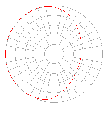 | ||||||||||||||||||
| Azimuth | Ratio | Azimuth | Ratio | Azimuth | Ratio | Azimuth | Ratio | ||||||||||||
| 0 | 0.963 | 10 | 0.923 | 20 | 0.862 | 30 | 0.797 | ||||||||||||
| 40 | 0.731 | 50 | 0.676 | 60 | 0.628 | 70 | 0.594 | ||||||||||||
| 80 | 0.571 | 90 | 0.558 | 100 | 0.553 | 110 | 0.558 | ||||||||||||
| 120 | 0.571 | 130 | 0.594 | 140 | 0.628 | 150 | 0.682 | ||||||||||||
| 160 | 0.738 | 170 | 0.815 | 180 | 0.897 | 190 | 0.953 | ||||||||||||
| 200 | 0.973 | 210 | 0.983 | 220 | 1.000 | 230 | 1.000 | ||||||||||||
| 240 | 1.000 | 250 | 1.000 | 260 | 1.000 | 270 | 1.000 | ||||||||||||
| 280 | 1.000 | 290 | 1.000 | 300 | 1.000 | 310 | 1.000 | ||||||||||||
| 320 | 1.000 | 330 | 1.000 | 340 | 1.000 | 350 | 0.991 | ||||||||||||
Structure Registration Number 1031582 Structure Type: TOWER Registered To: BUTTE BROADCASTING Structure Address: Sw 1/4 Of Section 14, Township 3 N. Range 7 W. Butte, MT County Name: Jefferson County ASR Issued: 10/16/1997 Date Built: 06/01/1984 Site Elevation: 2496.3 m (8190 ft.) Structure Height: 61 m (200 ft.) Height Overall: 61.9 m (203 ft.) Overall Height AMSL: 2558.2 m (8393 ft.) FAA Determination: 05/21/1984 FAA Study #: 84-ANM-576-OE Paint & Light FAA Chapters: 1, 3, 11, 21 RED LIGHTS/PAINT 46-00-23.0 N 112-26-31.0 W (NAD 83) 46-00-23.3 N 112-26-27.9 W (Converted to NAD 27) |
660 Dewey Blvd Po Box 3389 Butte, MT 59701 Phone: 406-494-7777 Corporation | Date: 02/16/2016 Application Certifier BUTTE BROADCASTING INCORPORATED 660 Dewey Blvd Butte, MT 59701 Applicant KEVIN TERRY 100 W Lyndale Ave Ste B Helena, MT 59601 TECHNICAL CONSULTANT DAWN SCIARRINO, ESQ. Sciarrino & Shubert, Pllc 5425 Tree Line Drive Centreville, VA 20120 | |||||||||||||||||
| |||||||||||||||||||