
FCCInfo.com
A Service of Cavell, Mertz & Associates, Inc.
(855) FCC-INFO
|
|
K229BO from 03/03/1997 |
|
|
||||||||||||||||
|
|
K229BO Channel: 229D 93.7 MHz Rancho Bernardo, Etc, California Service: FX - A translator or application for a translator. Facility ID: 86285 Fac. Service: FX Programming Delivery Method: Unspecified Status: License Application Accepted: 10/18/2010 Application Granted: 11/02/2010 File Number: BLFT-20101018AAB License Expires: 00/00/0000 Prefix Type: This is a license for a translator Application Type: License To Cover FCC Website Links: LMS Facility Details This Application CDBS Application Other K229BO Applications Other K229BO Applications in CDBS Including Superseded Applications Mailing Address Correspondence for K229BO Correspondence related to application BLFT-20101018AAB Service Contour - Open Street Map or USGS Map (60 dBu) Service Contour - KML / Google Earth (60 dBu) Class: D, A Noncommercial educational operating with no more than 10W Site Location: 33-00-32.2 N 116-58-19.1 W (NAD 83) Site Location: 33-00-32.0 N 116-58-16.0 W (Converted to NAD 27) Effective Radiated Power: 0 kW Horiz. ; 0.01 kW Vert. Transmitter Output Power: 0.007 kW Antenna Center HAAT: 0 m Horiz.; 564.9 m Vert. Antenna Center AMSL: 0 m Horiz.; 906 m Vert. Antenna Center HAG: 0 m Horiz.; 26 m Vert. Site Elevation: 880 m. (2887 ft.) Height Overall*: 28 m (92 ft.) (* As Filed In This Application, may differ from ASR Data, Below.) Directional Antenna Antenna Make/Model: None Antenna ID: 16150 Polarization:
| ||||||||||||||||||
| Antenna Data for Antenna Id: 16150 K229BO FX File: BLFT-20101018AAB None - Service: FX Pattern and Field Values Include a 260° Clockwise Rotation | 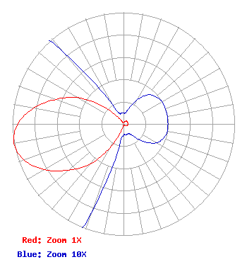 | ||||||||||||||||||
| Azimuth | Ratio | Azimuth | Ratio | Azimuth | Ratio | Azimuth | Ratio | ||||||||||||
| 0 | 0.010 | 10 | 0.010 | 20 | 0.015 | 30 | 0.025 | ||||||||||||
| 40 | 0.034 | 50 | 0.038 | 60 | 0.040 | 70 | 0.040 | ||||||||||||
| 80 | 0.040 | 90 | 0.040 | 100 | 0.040 | 110 | 0.038 | ||||||||||||
| 120 | 0.034 | 130 | 0.025 | 140 | 0.015 | 150 | 0.010 | ||||||||||||
| 160 | 0.010 | 170 | 0.010 | 180 | 0.010 | 190 | 0.020 | ||||||||||||
| 200 | 0.085 | 210 | 0.250 | 220 | 0.470 | 230 | 0.645 | ||||||||||||
| 240 | 0.820 | 250 | 0.950 | 260 | 1.000 | 270 | 0.950 | ||||||||||||
| 280 | 0.820 | 290 | 0.645 | 300 | 0.470 | 310 | 0.250 | ||||||||||||
| 320 | 0.085 | 330 | 0.020 | 340 | 0.010 | 350 | 0.010 | ||||||||||||
Structure Registration Number 1026468 Structure Type: TOWER Registered To: Palomar Communications, Inc. Structure Address: Woodson Mountain Near Poway, CA County Name: San Diego County ASR Issued: 11/30/2022 Date Built: 01/01/1980 Site Elevation: 880 m (2887 ft.) Structure Height: 28 m (92 ft.) Height Overall: 28 m (92 ft.) Overall Height AMSL: 908 m (2979 ft.) FAA Determination: 08/14/1997 FAA Study #: 97-AWP-1915-OE Paint & Light FAA Chapters: NONE Removed expiration date from determination. Scenario 1./jjs/case#635066 33-00-32.0 N 116-58-19.0 W (NAD 83) 33-00-31.8 N 116-58-15.9 W (Converted to NAD 27) |
3729 Cahuenga Blvd. West Los Angeles, CA 91604 Phone: 510-849-2590 | Date: 10/18/2010 Application Certifier PACIFICA FOUNDATION, INC. 1925 Martin Luther King Jr. Way Berkeley, CA 94704 Applicant DONALD E. MUSSELL JR NCE-CBT P.o. Box 983 Kilauea, HI 96754 CONSULTIING ENGINEER JOHN CRIGLER, ESQ. Garvey Schubert Barer 100 Potomac Street Nw 5th Floor Washington, DC 20007 | |||||||||||||||||