
FCCInfo.com
A Service of Cavell, Mertz & Associates, Inc.
(855) FCC-INFO
|
|
K259AT from 10/26/2006 K259AT from 01/23/2004 |
|
|
||||||||||||||||
|
|
K259AT Channel: 259D 99.7 MHz Boone, Iowa Service: FX - A translator or application for a translator. Facility ID: 152408 Fac. Service: FX Programming Delivery Method: Unspecified Status: License Application Accepted: 06/15/2015 Application Granted: 07/13/2015 File Number: BLFT-20150615AAO License Expires: 00/00/0000 Prefix Type: This is a license for a translator Application Type: License To Cover FCC Website Links: LMS Facility Details This Application CDBS Application Other K259AT Applications Other K259AT Applications in CDBS Including Superseded Applications Mailing Address Correspondence for K259AT Correspondence related to application BLFT-20150615AAO Service Contour - Open Street Map or USGS Map (60 dBu) Service Contour - KML / Google Earth (60 dBu) Class: D, A Noncommercial educational operating with no more than 10W Site Location: 41-50-02.9 N 94-02-12.8 W (NAD 83) Site Location: 41-50-03.0 N 94-02-12.0 W (Converted to NAD 27) Effective Radiated Power: 0.25 kW Transmitter Output Power: 0.14 kW Antenna Center HAAT: 0 m Antenna Center AMSL: 385 m (1263 ft.) Antenna Center HAG: 100 m (328 ft.) Site Elevation: 285 m. (935 ft.) Height Overall*: 108 m (354 ft.) (* As Filed In This Application, may differ from ASR Data, Below.) Directional Antenna Antenna Make/Model: None Antenna ID: 118171 Polarization:
| ||||||||||||||||||
| Antenna Data for Antenna Id: 118171 K259AT FX File: BLFT-20150615AAO None - Service: FX Pattern and Field Values Include a 340° Clockwise Rotation | 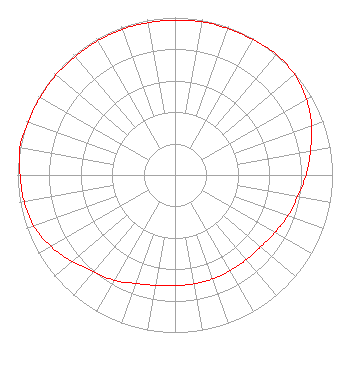 | ||||||||||||||||||
| Azimuth | Ratio | Azimuth | Ratio | Azimuth | Ratio | Azimuth | Ratio | ||||||||||||
| 0 | 0.983 | 10 | 0.988 | 20 | 0.988 | 30 | 0.992 | ||||||||||||
| 40 | 1.000 | 50 | 0.991 | 60 | 0.963 | 70 | 0.923 | ||||||||||||
| 80 | 0.873 | 90 | 0.832 | 100 | 0.792 | 110 | 0.762 | ||||||||||||
| 120 | 0.732 | 130 | 0.710 | 140 | 0.702 | 150 | 0.702 | ||||||||||||
| 160 | 0.702 | 170 | 0.702 | 180 | 0.702 | 190 | 0.712 | ||||||||||||
| 200 | 0.732 | 210 | 0.772 | 220 | 0.802 | 230 | 0.853 | ||||||||||||
| 240 | 0.909 | 250 | 0.953 | 260 | 0.973 | 270 | 0.983 | ||||||||||||
| 280 | 1.000 | 290 | 0.992 | 300 | 0.988 | 310 | 0.988 | ||||||||||||
| 320 | 0.983 | 330 | 0.983 | 340 | 0.983 | 350 | 0.983 | ||||||||||||
Structure Registration Number 1059648 Structure Type: TOWER Registered To: M & M Broadcasting, Inc. Structure Address: 2260 141st Dr Perry, IA County Name: Dallas County ASR Issued: 07/08/2014 Date Built: 07/15/1995 Site Elevation: 285 m (935 ft.) Structure Height: 108 m (354 ft.) Height Overall: 108 m (354 ft.) Overall Height AMSL: 393 m (1289 ft.) FAA Determination: 05/05/1992 FAA Study #: 70-CE-9-OE Paint & Light FAA Chapters: 1, 3, 12, 21 RED LIGHTS/PAINT 41-50-03.0 N 94-02-13.0 W (NAD 83) 41-50-03.1 N 94-02-12.2 W (Converted to NAD 27) |
Po Box 31 1610 N Lincoln Street Knoxville, IA 50138 Phone: 641-842-3161 Corporation | Date: 06/15/2015 Application Certifier M & M BROADCASTING, INC. P.o. Box 31 1610 N. Lincoln Knoxville, IA 50138 Applicant B. BENJAMIN EVANS, P.E. P.o. Box 225 Mequon, WI 53092 CONSULTING ENGINEER DAVID OXENFORD, ESQ. Wilkinson Barker Knauer, Llp 2300 N Street, N.w. Suite 700 Washington, DC 20037-1128 | |||||||||||||||||