
FCCInfo.com
A Service of Cavell, Mertz & Associates, Inc.
(855) FCC-INFO
|
|
|
|  |
|
|||||||||||||||
|
|
WBNH Channel: 203B 88.5 MHz Pekin, Illinois Service: FM - A full-service FM station or application. Facility ID: 9893 Fac. Service: FM Status: License Application Accepted: 09/06/2006 Application Granted: 09/25/2006 File Number: BLED-20060906AAM License Expires: 00/00/0000 Prefix Type: This is a license for a noncommercial educational FM station Application Type: Amendment FCC Website Links: LMS Facility Details This Application CDBS Application Other WBNH Applications Other WBNH Applications in CDBS Including Superseded Applications Mailing Address Correspondence for WBNH Correspondence related to application BLED-20060906AAM Service Contour - Open Street Map or USGS Map (60 dBu) Service Contour - KML / Google Earth (60 dBu) Public Inspection Files Facility Type: NON-COMMERCIAL EDUC. FM Class: B, A Zone I or I-A station; with 25kW-50kW ERP and a class contour distance 39km-52km Site Location: 40-38-53.1 N 89-33-26.3 W (NAD 83) Site Location: 40-38-53.0 N 89-33-25.9 W (Converted to NAD 27) Effective Radiated Power: 48 kW Transmitter Output Power: 7.61 kW Antenna Center HAAT: 154 m (505 ft.) Antenna Center AMSL: 339 m (1112 ft.) Antenna Center HAG: 141 m (463 ft.) Site Elevation: 198 m. (650 ft.) Height Overall*: 152 m (499 ft.) (* As Filed In This Application, may differ from ASR Data, Below.) Directional Antenna Antenna Make/Model: Electronics Research Inc. 1094-6CP-DA, six sections one wavelength spaced Antenna ID: 68961 Polarization:
| ||||||||||||||||||
| Antenna Data for Antenna Id: 68961 WBNH FM File: BLED-20060906AAM Electronics Research Inc. - 1094-6CP-DA, six sections one wavelength spaced Service: FM | 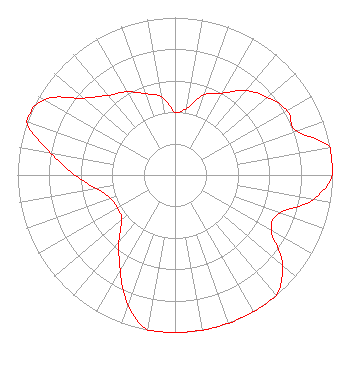 | ||||||||||||||||||
| Azimuth | Ratio | Azimuth | Ratio | Azimuth | Ratio | Azimuth | Ratio | ||||||||||||
| 0 | 0.400 | 10 | 0.430 | 20 | 0.541 | 30 | 0.600 | ||||||||||||
| 40 | 0.700 | 50 | 0.770 | 60 | 0.820 | 70 | 0.820 | ||||||||||||
| 80 | 1.000 | 90 | 1.000 | 100 | 0.890 | 110 | 0.707 | ||||||||||||
| 120 | 0.707 | 130 | 0.890 | 140 | 1.000 | 150 | 1.000 | ||||||||||||
| 160 | 1.000 | 170 | 1.000 | 180 | 1.000 | 190 | 1.000 | ||||||||||||
| 200 | 0.878 | 210 | 0.697 | 220 | 0.554 | 230 | 0.440 | ||||||||||||
| 240 | 0.420 | 250 | 0.435 | 260 | 0.505 | 270 | 0.636 | ||||||||||||
| 280 | 0.800 | 290 | 1.000 | 300 | 0.957 | 310 | 0.760 | ||||||||||||
| 320 | 0.660 | 330 | 0.610 | 340 | 0.550 | 350 | 0.504 | ||||||||||||
Structure Registration Number 1247127 Structure Type: GTOWER Registered To: Illinois Central Radio Fellowship Inc. Structure Address: Wooded Area Near End Of Highpoint (a South Frontage Road To I-74) Near East Peoria, IL County Name: Tazewell County ASR Issued: 04/10/2014 Date Built: 03/22/2006 Site Elevation: 198 m (650 ft.) Structure Height: 150 m (492 ft.) Height Overall: 152 m (499 ft.) Overall Height AMSL: 350 m (1148 ft.) FAA Determination: 04/08/2013 FAA Study #: 2013-AGL-1294-OE FAA Circular #: 70/7460-1K Paint & Light FAA Chapters: 4, 6, 12 PRIOR STUDY 2004-AGL-7661-OE CHAPTERS 4,6,12 (1K) ADD SPECIAL CONDITION FOR LIGHTING DEVIATION 40-38-53.0 N 89-33-26.0 W (NAD 83) 40-38-52.9 N 89-33-25.6 W (Converted to NAD 27) |
1919 Mayflower Drive Pekin, IL 61554 Phone: 309-636-8850 Not-for-Profit | Date: 09/06/2006 Application Certifier CENTRAL ILLINOIS RADIO FELLOWSHIP, INC. P.o. Box 1132 Pekin, IL 61555-1132 Applicant ROBERT MOORE 1908 Sweetbriar Dr Goshen, IN 46528 CONSULTING ENGINEER JEFFREY D. SOUTHMAYD Southmayd & Miller | |||||||||||||||||
| |||||||||||||||||||